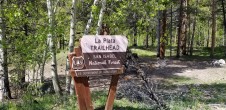
6/24/2015 Posted On: 6/27/2015 By: BillMiddlebrook Info: Open and the dirt road between the trailhead and the start of the trail is dry | ||||
12/27/2014 Posted On: 12/27/2014 By: vdavidoff Info: Road plowed and clear (less some patches of packed snow) to the trailhead. Trailhead parking area is not plowed, however. | ||||
8/16/2014 Posted On: 8/17/2014 By: Lute82 Info: room for several tents right at trail head, saw at least 5 decent amout of parking. | ||||
7/23/2014 Posted On: 7/23/2014 By: I fall a lot Info: Agreed with msmiller, spoke to both bridge contractor and Park Ranger, both said it should be open as of today 7-23-14. | ||||
7/23/2014 Posted On: 7/23/2014 By: BillMiddlebrook Info: OPEN | ||||
7/22/2014 Posted On: 7/22/2014 By: msmillertx Info: I talked with the Park Ranger this morning who informed me the bridge should be finished this afternoon! She assured me there would be no problem hiking across the creek this weekend. | ||||
7/13/2014 Posted On: 7/15/2014 By: boudreaux Info: The TH is still closed due to the bridge work, and the creek is still running high! A couple of places to park off the road are just to the west of the TH and on the southside, but the creek is the crux of the whole thing! | ||||
6/6/2014 Posted On: 7/8/2014 By: BillMiddlebrook Info: IMPORTANT NOTICE FROM THE U.S. FOREST SERVICE: The Forest Service is in the process of replacing the bridge on FR 391 (South Fork Lake Cr. Road) over the North Fork of Lake Creek. All access to the Northwest Ridge and Ellingwood Ridge routes up La Plata will be closed until after the bridge replacement project is completed. We anticipate completion by July 19, 2014. Work began on this bridge on June 2, and although the area is well signed, the contractor is having issues with people parking in his way, and walking over the bridge that they are in the process of dismantling. Leadville Ranger District San Isabel National Forest 719 486-7409 If you still want to hike La Plata Peak from this trailhead, you'll need to park away from the work area (possibly along Highway 82 where you can safely get off the pavement) and find a way to cross the creek, just south of the highway, to regain the dirt road. The water level in Lake Creek will likely be quite high while the bridge is closed so BE CAREFUL if you decide to cross. | 1 |
|||
5/26/2014 Posted On: 5/27/2014 By: ctlee Info: Took a drive over Independence Pass to check out some trailhead conditions. There‘s a sign at the LaPlata trailhead that says the bridge will be impassable to auto and pedestrian traffic from 5/27-7/12. Never having done it before, I don‘t know if the bridge crossing is necessary or if there‘s another way through there-figured a heads up was good before anyone took the long drive up there! | 3 |
|||
11/30/2013 Posted On: 12/1/2013 By: cjfessler Info: Could not reach trailhead with 2011 Subaru Outback. We made it about 4 mikes out before getting stuck in the snow. Probably could have made it a bit further with a V-6. We were definitely the first car on the road for a while. Made for a good snowshoe day! Would recommend skiing in as we had to break trail all the way to the trailhead. | ||||
9/4/2013 Posted On: 9/21/2013 By: bking14ers Info: We drove a KIA Sorento all the way to the 4WD parking area, past the West Winfield TH. It is rough going in places but passable by any higher clearence vehicle to that point. The Chaffee County 390 road is a washboard all the way back. That was a long anoying drive back in, but OK for any car at least untill the WWTH. | ||||
8/3/2013 Posted On: 8/3/2013 By: winmag4582001 Info: Started up the road at 5am. No moon was out and it was darker than the inside of a goat! I walked right past the trailhead. Luckily there were 4 guys coming back down the road that had done the same thing. *Note: If you are leaving in the dark, the trailhead is roughly 450 steps past the end of the bridge, about 20 steps past the green gate. Also, when you get to the creek, do NOT follow parallel to the creek, the bridge is straight in front of you. If you look next to the tree that the trail runs into, you will see three rock steps. This may sound obvious, but if its your first time there and you are in the dark, it will help. The trail is easy to follow when you get past the bridge. | ||||
2/21/2013 Posted On: 2/22/2013 By: vdavidoff Info: Yesterday on the way to the trail head, 82 was unplowed after about .5mi from 285. I was on 82 from 5am to 6am driving through fresh snow and didn‘t see a single soul, let alone a snow plow. Signage on the road indicates that there is no plowing 7pm to 5am, so the absolutely earliest 82 would be plowed would be sometime after 5am. When I left the trail head at 3pm, the road was basically totally clear, having been plowed and melted by the sun. The point of this report is to indicate the hours during which the road is definitely not plowed. | ||||
3/17/2012 Posted On: 3/19/2012 By: semitrueskerm Info: Easy access as always to the NorthWest La Plata Trailhead. An incredible amount of snow has melted in the last four weeks. Watch out for the ice-sheet on the road/trail between the parking lot and the bridge a tenth of mile down yonder. A spill here is the equivalent of falling on a ski mountain catwalk... ouch! | ||||
1/2/2012 Posted On: 1/3/2012 By: RJansen77 Info: Paved and plowed all the way, easy for any car. |


