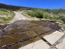
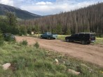
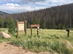
6/10/2020 Posted On: 6/12/2020 By: KarenG Info: Drove in late in the day and the trees were cleared from the road. | ||||
6/7/2020 Posted On: 6/7/2020 By: Aphelion Info: Creek crossings are shallow and should be easy for any vehicle that can manage the dirt road. However, there are a number of wind-blown trees partially (and in one case fully) blocking the road, necessitating driving half-off the shoulder or completely over a fallen trunk. Anything with Subaru-level clearance will be fine, but lower-clearance cars should stay away until these get removed. | ||||
6/6/2020 Posted On: 6/9/2020 By: greenonion Info: This is now maybe old news but could help as a reminder/warning. On Saturday 6/6 I was 5-6 miles from the Stewart Creek TH with an eye on doing San Luis' NE ridge. The wind was howling on the way to the TH and there were A LOT of dead trees all around. I got to one downed tree across the road and was able to clear it just enough to drive a bit further to find another smaller one, then decided this was not a good idea to be in that area with that wind. As I retreated while heading out another one had fallen across the road and I had to clear that one. Was very glad none of those were bigger trees. Keep big wind in mind and what kind of trees are around when heading to THs and hiking in general. Also heard a few creaking among the many dead trees on parts of the Little Borwn's Creek route up on Sunday. None fell there that I saw, and no treasure either. | ||||
5/17/2020 Posted On: 5/19/2020 By: hogantheepic Info: Road clear of snow the entire way out. Only a teeny bit of snow but it can easily be driven around. The 2 creek crossing are not too deep yet, but will probably be getting deeper each day. | ||||
8/23/2019 Posted On: 8/24/2019 By: bosnian2014 Info: water crossings were not bad at all. made it to TH in a bmw sedan with 5.9 in clearance. | 2 |
|||
8/23/2019 Posted On: 8/24/2019 By: dwoodward13 Info: I drove from Lake City to the Cebolla TH via Los Pinos Pass. Although not Stewart Creek, it may be useful for those looking to go from here to Lake City or vice versa. Was pretty comfortable in a Camry to go over Los Pinos. Rocky in spots requiring slow going, but nothing requiring clearance or 4wd. | 1 |
|||
8/22/2019 Posted On: 8/22/2019 By: wildserval Info: Road is in good condition. Made creek crossings in a stock Chevy Tahoe without problems. Some logging in area closer to Trailhead, did not cause me an issue. Watch for dead treefall, pine beetles have killed many trees in area. | ||||
7/28/2019 Posted On: 7/30/2019 By: emcee smith Info: Went through the water crossings with a Subaru Outback with no problems. I'd suspect it is fine for any reasonable clearance car, just probably wouldn't stop halfway across. | ||||
7/6/2019 Posted On: 7/6/2019 By: Flyingfish Info: Creek crossings are passable for stock SUVs but probably still to high for anything smaller than a Subaru Forrester. | ||||
6/22/2019 Posted On: 6/22/2019 By: djacobson Info: Road is in great condition. Stream crossings were not bad at all. See attached photos. Maybe 2-2.5 feet deep at worst point. Several Subarus (think I saw a Forester and XV) made it up to the trail head. My Jeep had no issue. Road was completely clear and no snow. As mentioned in a previous post there were several downed trees but nothing that blocked passage. | 2 |
|||
11/10/2018 Posted On: 11/10/2018 By: WildWanderer Info: I agree with previous report: don't let the 15 miles of easy/dry 2WD driving before the first creek crossing fool you, those last 6-10 miles to Stewart Creek Trailhead and past to the Eddiesville Trailhead are icy! Despite my stellar driving skills, my 4WD Tundra was sliding sideways down some of those hills at 5am. Still icy but better conditions in the afternoon. | 2 |
|||
11/7/2018 Posted On: 11/7/2018 By: Squirrellysquirrel Info: Best to have 4x4 or AWD to get to Stewart Creek TH. Muddy spots throughout and snow pack at higher elevations makes for slick road conditions. | ||||
10/6/2018 Posted On: 10/7/2018 By: pbergmaier Info: As previous reports have stated, road is in excellent condition. A bit bumpy in a few spots, but not bad at all. The first creek crossing was trivial, hardly any water at all. The second creek crossing was deeper (maybe 8-10 inches deep) but still nothing to worry about, the water was moving very slowly. Google Maps took us right to the trailhead, but it overestimated the time it would take by at least half an hour. I was able to drive the 28 miles of dirt road in about 45-50 minutes. | ||||
6/24/2018 Posted On: 6/24/2018 By: AcornMan Info: Although it's a long drive on an unpaved road to the trailhead, the road is in excellent condition with only a handful of mildly rough spots. I easily made it in a Subaru Outback, often driving 30-40 mph. Any 2WD that isn't unusually low to the ground should make it just fine EXCEPT that the two stream crossings could be problematic if they're running high. Right now, both are very low and easy to cross. I did not see anyplace to camp at the trailhead. | 1 |
|||
6/23/2018 Posted On: 6/24/2018 By: jennincolorado Info: |


