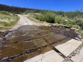
7/4/2014 Posted On: 7/5/2014 By: colorajo Info: The first stream was low enough to go through in a Buick LaCrosse, but the second (Nutras) was a little too high for my comfort. | ||||
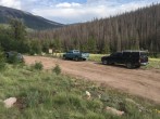
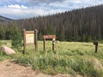
6/25/2014 Posted On: 6/26/2014 By: CraigMeier Info: Trailhead parking lot described in Stuart Creek trailhead is permanently closed as of 6/25/14. Parking is on side of road by trailhead or a quarter mile further down the road at the Horse Corral parking lot. They were doing a lot of road improvements and the road into the trailhead is accessible with a car now. They also installed a new trailhead sign next to the road so it is easy to find. They also installed a new outhouse bathroom by the parking lot a quarter mile past the trailhead. Nice improvements to the trailhead area! | ||||
6/24/2014 Posted On: 6/25/2014 By: The_Flex Info: 24 June should be the last day the Trailhead parking area is available. It is being closed down, with parking being made available along the road next to it. Also, a double restroom is being added at that location. | ||||
6/14/2014 Posted On: 6/16/2014 By: transplant_hiker Info: The road is in pretty decent shape. The stream crossings (2) are not very bad and most any SUV or truck should be able to make it without an issue. The streams are flowing much higher during the afternoon so be aware that the volume of water in the morning will be less than when you leave in the afternoon. I drove an F-150 without any issues and I would imagine most SUVS and the like would make it, no problem. | ||||
6/11/2014 Posted On: 6/15/2014 By: grayp Info: Road 15-GG or FR 794 was very rough on the way in. Large exposed rocks, huge ruts, and washed out areas. The first creek crossing was fairly deep and fast moving. The water was about 8-10 inches deep. The second creek crossing wasn't bad. The water was about 5 inches. We thought we were stupid for taking a Nissan Murano to the trailhead but we saw a later model Toyota Camry arrive to the trailhead as we were setting up camp for the night. The road had been worked on while we were hiking so the drive out wasn't very rough at all. There were still a few areas that had some fairly large ruts in the road but if you take them slow you could easily make it in a lower clearance vehicle. I attached pictures of the first creek crossing. I recommend driving through the upstream portion of the creek because the water is calmer and more shallow. | 2 |
|||
6/1/2014 Posted On: 6/2/2014 By: Mujahid Info: High clearance vehicles required to cross Nutras and Chavez creeks. Rest of road is not bad. | ||||
5/27/2014 Posted On: 5/28/2014 By: bunny256 Info: Road 14dd (794) is in terrible shape right now. Huge ruts and washed out areas, large exposed rocks, etc. 2 stream crossings are well over a foot deep from spring runoff. A rough ride even in an Xterra. It appears that a bit of road work is in progress, but until it is complete I would not recommend that any passenger car attempt this road. | ||||
10/19/2013 Posted On: 10/20/2013 By: Yikes Info: (for Cebolla TH) Roads in the area are dry for the first 10 miles or so, then snow packed off/on. The last 2 miles to Cebolla had 4" of snow but was passable due to the heavy hunter traffic. Sloppy, muddy mess later in the afternoon. | ||||
9/15/2013 Posted On: 9/16/2013 By: matt pierce Info: Still Open - spent the weekend at/near Stewart Creek - road was quite muddy but very passable. Standard route for San Luis pretty wet and muddy but no snow. I had the summit to myself Sat but graupel and rain on the hike out... | ||||
8/31/2013 Posted On: 9/1/2013 By: markhingston Info: The last 5 miles of road are getting chewed up and there is construction at Naturas Creek crossing, 2 miles north of the trailhead. Trailhead parking area has large rocks so regular clearance vehicles are parking on the road above the trailhead. | ||||
8/10/2013 Posted On: 8/20/2013 By: trishkaken Info: In the event you find this information useful, there are NO restroom facilities at this trail head. I could not find that information anywhere so I thought maybe others would be interested as well. There is a restroom about 5 miles prior to the trail head on the road to Stewart Creek but on the day we traveled the road (and the next day), they were dead bolted. | ||||
7/17/2013 Posted On: 7/17/2013 By: Bum Ellis Info: I drove in from Lake City via Slumgullion Pass/Deer Lakes/Los Pinos Pass (took me approximately 2 hours each way), and the roads were great until the last stretch that connects with the Stewart Creek TH. The last part wasn‘t bad, just not as smooth. Watch out for ruts caused by rain draining across the road, as they give you a surprising jolt if you aren‘t expecting them. Also, the trail has a bunch of tall grass, etc. along the edge that hangs over the trail itself. Might want to consider wearing pants if that bothers you. | ||||
6/15/2013 Posted On: 6/15/2013 By: My-Therapy Info: Road all the way to trail head is dry and in good condition. I think basically any car could make it, however if your driving a low clearance vehicle there are a few spots you‘ll want to go slow and be careful not to bottom out because of a few dips/potholes. | ||||
9/24/2012 Posted On: 9/28/2012 By: Knockneed Man Info: The road is bone dry and in good condition. Snowed lightly above 12k feet. | ||||
8/26/2012 Posted On: 8/27/2012 By: Scott P Info: The road is in good condition for all cars (when driven slowly). Since the road is in good condition, still watch your speed as there are a fill rills in the road that are hidden until you get close to them. |


