| Report Type | Full |
| Peak(s) |
Mount Russell - 14094 |
| Date Posted | 07/08/2014 |
| Date Climbed | 07/06/2014 |
| Author | jf32 |
| Additional Members | ngoodnight, JosephG |
| CA 14er - Mount Russell - East Ridge |
|---|
Mount Russell, 14,094ft, has been a peak I have been excited about for some time. My favorite type of climbing involves short approaches and class 3 to 4 ridges with dramatic exposure and solid rock. Mount Russell was said to offer this combo and as such had the potential to vault its way towards the top of my favorite 14er list. It did not disappoint.  Route: East Ridge. I have seen mileage estimates from 9-14 miles round trip for this route. Our GPS track indicated we traveled about 12 miles and just over 6,000 vertical. The Permit: The plan took shape early this winter. After getting familiar with Whitney Portal Permit Rules we discovered that an overnight trip up the North Fork of Lone Pine Creek, which is the main access point for the Mountaineer's Route on Mount Whitney as well as Mount Russell and a host of technical climbs on both peaks, would bypass the Whitney lottery - a day hike would require a Lottery permit. Even though the overall mileage and elevation gain is reasonable for a long day trip we opted for the pack in to avoid the lottery. In early February, 6 months before our hoped for 4th of July weekend trip, we secured our permits and Mount Russell was officially on the calendar. The team consisted of Nolan (ngoodnight), Joe (Josephg), Clark (a California native who hasn't had the pleasure to properly enjoy the Colorado mountains and as such has no 14ers.com username - poor guy) and myself (jf32). Trip logistics (no climbing info in this section): The trip started at San Francisco International airport on Thursday July 3rd. Nolan and Clark picked up Joe who was flying in from Colorado and I met them there as it was the most convenient point for me to reach them after my work day ended. We piled into Nolan's Jeep and started the long drive to Yosemite. No drive to Yosemite would be complete without a stop at Firenze in Oakdale to fuel up on some pizzas. We arrived at an undisclosed location near Tioga Pass and hastily set up camp for our first night of acclimation, sleeping at around 10,000ft. After moving from Colorado to sea level I have had a difficult time with altitude sickness whenever heading up high. As a result I have been extra mindful to plan trips with as much acclimatization time as possible. We woke up on the 4th surrounded by the high peaks of Yosemite. We stopped in at the Mobile Station, possibly the world's greatest gas station, to pick up some giant breakfast burritos and bagels before continuing on to the towns of the Eastern Sierra that dot Route 395. We were all a bit down when we found out that the Pizza Factory, a staple on our Sierra trips in the past, was closed on the 4th. Fortunately the Upper Crust in Bishop stepped in to fill our almost insatiable desire for pizza. After picking up our food and watching some of the World Cup we headed to Mount White's Trailhead. Along the drive in we passed through the Ancient Bristlecone Pine Forest which has the oldest living trees in the world. Some of the trees are 4,000-5,000 years old. Mount White at 14,252ft is another of California's ranked 14ers. Once at the Mount White Trailhead Nolan and Clark ran up to tag the summit (it took them just over 5 and a half hours) while Joe and I leisurely set up camp while enjoying some seasonal selections from Mammoth Brewing Company. Joe and I had previously climbed White otherwise we would have joined the hike up. In addition to Nolan and Clark getting another mountain on this trip the trailhead is at about 12,000ft. This was our campsite for the night and would hopefully provide me enough acclimatization to handle Russell. It also provided one of the best views of the Milky Way I have ever seen. The Pack into High Camp: Waking up on July 5th we broke camp at the Mount White Trailhead and went to the Lone Pine Ranger Station to pick up our permits. This is the only ranger station where you can pick up permits leaving from the Whitney Portal. We got our permits and had a delicious breakfast at Alabama Hills Cafe and then went to a shady spot at Diaz Lake to avoid the heat while we sorted and packed our gear. At around 11, after finding an open Pizza Factory for one last pie to pack in, we hit the trail. The approach trail is 4.5 miles and 3,000ft vertical to Upper Boyscout Lake, the base of the Mount Russell climb. The trail can be broken into 3 sections. Section 1 - about 1 mile on the Whitney trail before the marked turn off at Upper Lone Pine Creek (the 2nd stream crossing). This section is mild and quite pleasant, particularly on the descent. From the turn off there is a well-marked and steep trail that has 2 stream crossings as it approaches the base of Section 2, the Ebersbacher Ledges. The ledges provide the work around to the huge granite slabs that make up this basin. Make sure to get a decent idea of where these ledges start prior to your hike - there are a few good pictures on available trip reports out there. The ledges require a few interesting moves that were mostly fine while dry on the way up but required quite a bit of extra care while wet on the way down. A quick note on route finding - on the descent there is a use trail that continues down the north side of the valley at the base of the ledges. Don't follow it - be mindful to cross the north fork of Lone Pine Creek where you did on the ascent - unless you enjoy willows. Once you complete the ledges section you are just below/at Lower Boyscout Lake, which is a truly beautiful lake surrounded by waterfalls and pine trees. This would be a lovely place to camp. Our destination though was Upper Boyscout lake, an equally beautiful but very different lake. Its beauty was in its towering granite walls and otherworldly terrain. The hike up to Upper Boyscout from Lower, Section 3, is about 1,000ft up a well-marked trail that passes around a number of waterfalls and over a few granite slabs. We made our way up to Upper Boyscout and set up camp by 3 PM. This was my 3rd night sleeping above 10,000ft and thankfully it was enough to help me properly acclimate. The Climb: With good cell phone service we could see that weather conditions were going to be less than ideal with rain storms expected after 11. We opted for a 4 AM wake up thinking it would take us 5 hours to get to the summit and back to camp. This would give us an hour cushion before any weather hit the mountain. Our timing was correct (it took 5 hours and 10 minutes from camp to camp) but as you'll see in the pics the weather moved in earlier than predicted. From camp we followed a use trail to the roughly 1,200ft sand/scree slope that is the standard route. We stayed on the extreme left of this slope choosing our own lines while looking for the most solid footing. We actually strayed too far left topping out at a notch with a rock tower preventing access to the plateau. Instead of down climbing and hiking around this last remaining obstacle to the high plateau we opted to simply climb it. It was solid class 3 and provided a warm up for the ridge ahead. Once atop the scree slope there is a long and gentle plateau that gradually rises to the Russell/Carillon saddle. Again we followed a use trail to the saddle enjoying the the views of Mount Whitney to the South. Once at the saddle we started climbing up the east ridge to the east summit. The rock was solid and the going was smooth with many options to choose from and occasional trail segments scattered about. The route we selected was just north of the ridge or the ridge proper. When on the ridge proper the exposure and views were simply stunning (if that's your kind of thing). We slowly made our way up to the East Summit and then traversed the short distance over to the true West Summit. The crux of the climb is a mantle move that is easily bypassed on the north side of the ridge on the traverse between the 2 summits (3/4 of us bypassed it). All told this was a spectacular ridge run with amazing rock that allowed several options over or around all obstacles (if you choose not to climb them that is). Weather: Just a quick note here. There were rain (note not thunder) storms in Owens Valley most of the morning and we knew we were likely to get wet early on. Our hope was to be back at the saddle prior to any weather directly threatening us. We were an hour or so off with clouds/fog moving in around 7:45 AM. In addition to creating some great photo ops this also made us evaluate and re-evaluate our decision to move upward. Ultimately we were prepared to turn around but felt that we were comfortable moving forward even if that meant dealing with wet rock on the ridge and traverse. We did get some snow and rain showers but it was only on our descent from the East Summit to the saddle, with most of the 'hard' stuff behind us. The rain showers also were an issue lower on the hike out as we descended the Ebersbacher Ledges. Back to SF: Aside from a waitress brutally and hilariously critiquing her own restaurant the only other thing worth noting on the way home is that 4th of July traffic stinks especially if you have to travel 350+ miles. Thanks for reading - enjoy the pics!  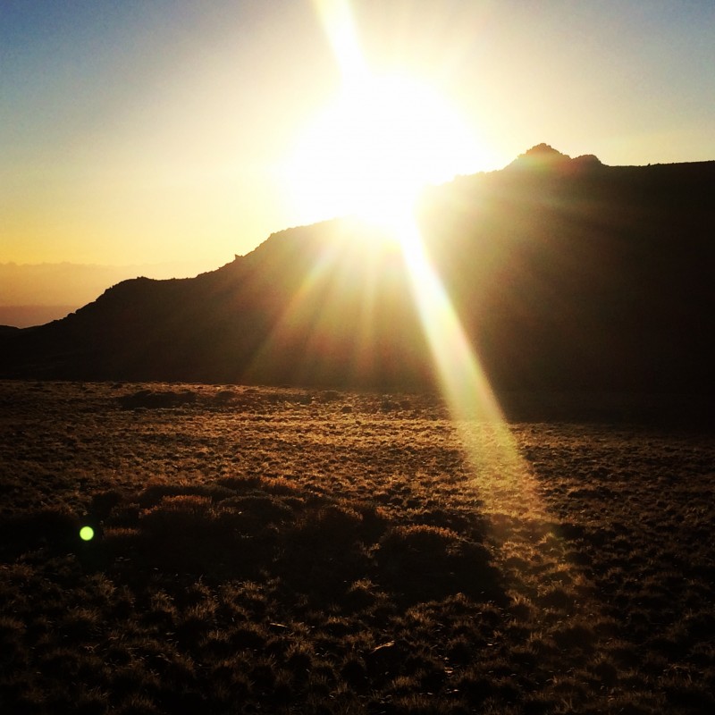 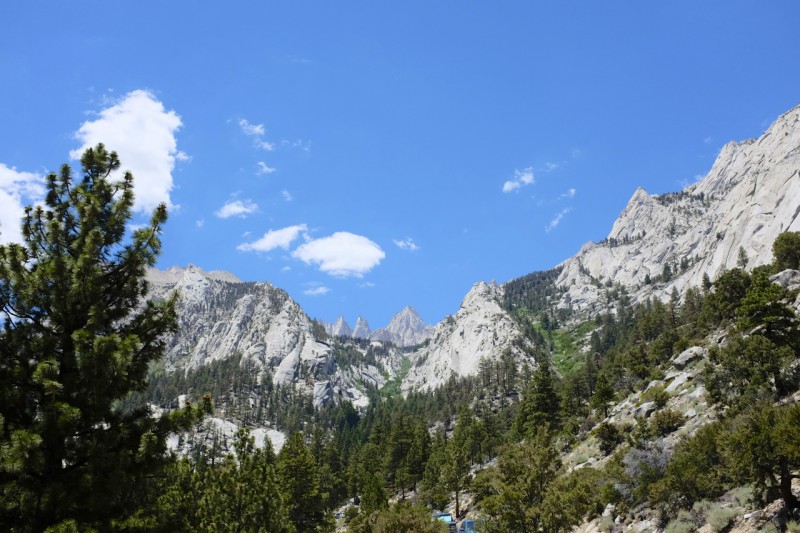  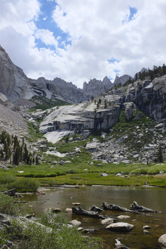       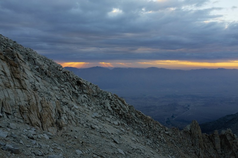  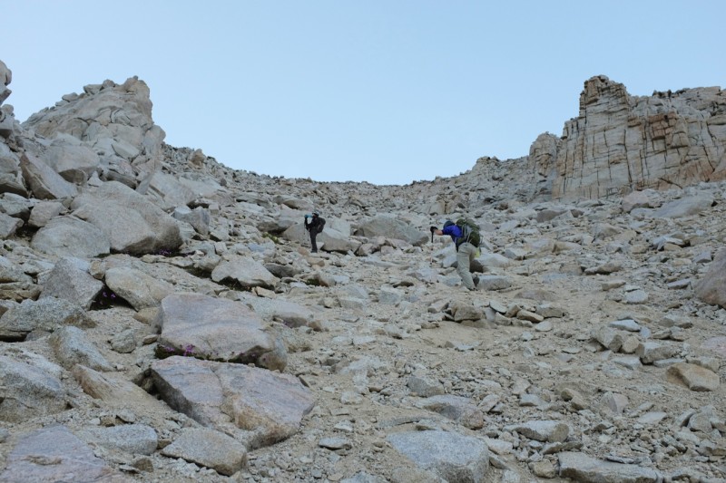  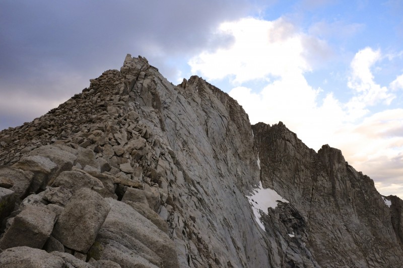 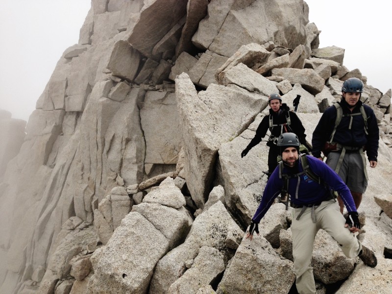  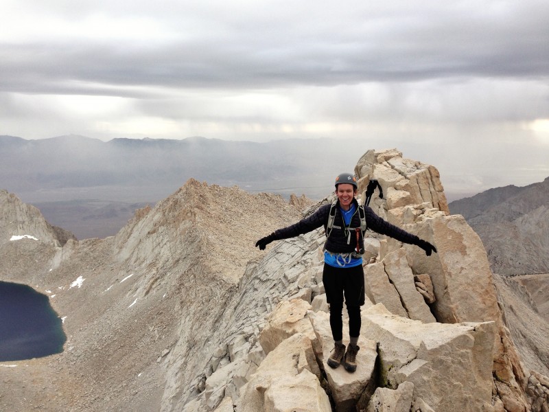 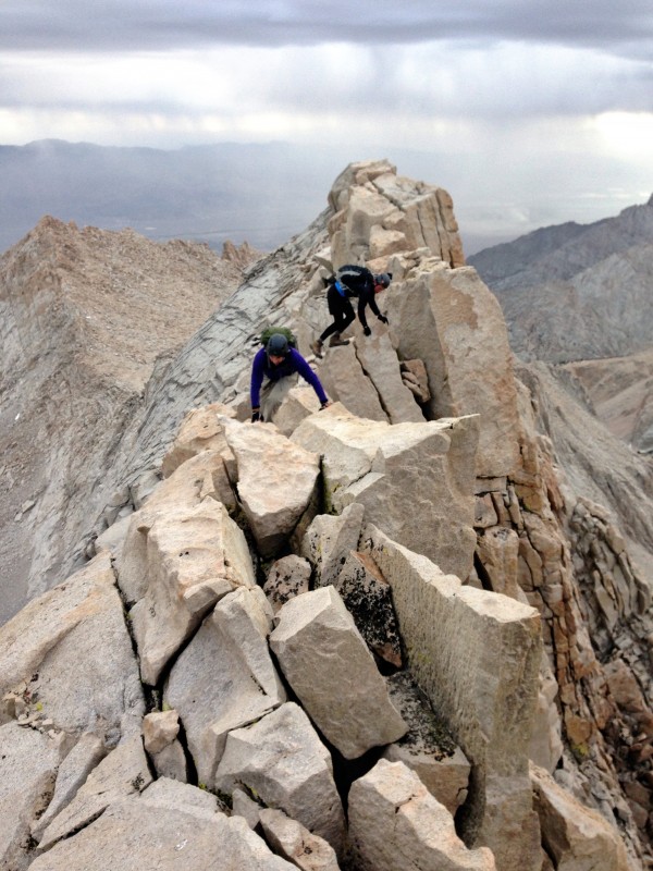    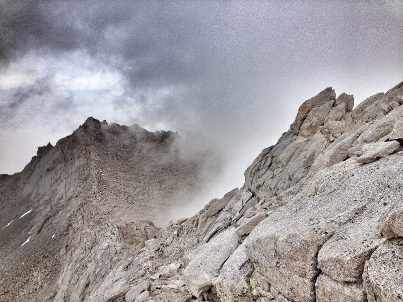 Thumbnails for uploaded photos (click to open slideshow):  Are we having fun yet? Photo Credit Nolan")
 Camp near Upper Boyscout Lake")
 Admiring Whitney. Photo credit Clark")
 Ascending the scree slope - Photo credit Clark")
 Checking out the East Ridge from the saddle - Photo credit Clark")
 Lower Boyscout Lake - Photo credit Clark")
 The only summit shot we managed! - Photo credit Clark")
 The scree slope. We climbed left of the tower on the left and chose to scramble over it to reach the plateau. Photo credit")
 Mount Whitney as seen on the drive in. Photo credit Clark")
 Sunrise high on Russel - Photo credit Clark")
 Working our way up the ledges")
 A few of the waterfalls that empty into Lower Boyscout Lake")
 4AM wakeup!")
 What a ridge")
 Approaching Upper Boyscout - Photo credit Joe")
 A look at the White Mountains across the valley. Photo credit Joe")
 Mount Russel - Photo credit Joe")
 See ya Russell!- Photo credit Joe")
 Mount Russell from camp at Upper Boyscout - Photo credit Joe")
 Hanging out below the East Summit - Photo credit Joe")
 Camp at Mount White")
 Sunset from camp at Mount White")
 Which way do I go? Photo credit Nolan")
 do not use")
 This is how you run a ridge - Photo credit Nolan")
 Descending the Plateau - Photo credit Nolan")
 Camp at Upper Boyscout")
|
| Comments or Questions | ||||||||||||||||||
|---|---|---|---|---|---|---|---|---|---|---|---|---|---|---|---|---|---|---|
|
Caution: The information contained in this report may not be accurate and should not be the only resource used in preparation for your climb. Failure to have the necessary experience, physical conditioning, supplies or equipment can result in injury or death. 14ers.com and the author(s) of this report provide no warranties, either express or implied, that the information provided is accurate or reliable. By using the information provided, you agree to indemnify and hold harmless 14ers.com and the report author(s) with respect to any claims and demands against them, including any attorney fees and expenses. Please read the 14ers.com Safety and Disclaimer pages for more information.
Please respect private property: 14ers.com supports the rights of private landowners to determine how and by whom their land will be used. In Colorado, it is your responsibility to determine if land is private and to obtain the appropriate permission before entering the property.