| Report Type | Full |
| Peak(s) |
Little Bear Peak - 14,041 feet |
| Date Posted | 08/01/2014 |
| Date Climbed | 07/13/2014 |
| Author | Wish I lived in CO |
| Additional Members | Ghigs |
| Little Bear SW Ridge |
|---|
LITTLE BEAR PEAKSUN. JULY 13, 2014 Route: SouthWest Ridge, TH Elev: 8,800 ft, Summit: 14,037 ft, RT Distance: 9.5 miles, Elevation Gain: Somewhere between 6,000 - 7,000 ft Climbers: Pete (Wish I Lived in CO), Tom (Ghigs)  THE CLIMB Because I only had a couple days available for this years trip, I had to turn down a great offer from "Roald" to climb Capitol (good luck this weekend Mark!). Fortunately, Tom (Ghigs) took my offer to join for Little Bear. The standard route offers a road (if you'd call it that) that one can hike up to a beautiful lake to camp at, and then a relatively short climb to Little Bear's summit. However the crux of that route involves technical climbing up a steep gully on smooth, often wet rock with small and few hand and footholds. This gully climb is further complicated by severe rockfall potential as rocks can funnel into the narrow section where the most difficult climbing is. The area is informally and appropriately named "the hourglass". Accomplished climber and author Gerry Roach describes the hourglass as "the most dangerous spot on any of the standard routes on Colorado's fourteeners." Being a recreational climber, this was not one route that I wanted anything to do with. Yet I wanted to climb Little Bear since, if possible, I hope to climb all 58 of Colorado's fourteeners. Enter the SouthWest ridge route. There is no trailhead or trail. No one to be seen on most of the route. Endless talus. At least 6,000 plus foot of gain. Many climbers take 12-16 hours to complete the route. Even in getting to the "trailhead", access is questionable as the roads are debatable as to whether they are public or private and whether they are legal to cross (my opinion was for legal, but just my opinion). Anyway, Tom and I met the previous evening at the "trailhead", which simply consists of the furthest extent of some 4WD roads that end at the edge of the national forest. We departed around 2:30 am, in order to stay ahead of typical July afternoon monsoon thunderstorms. While I had scouted out the first half-mile through the woods easy enough the afternoon before, we did more bush-wacking in the dark than I had planned on (always easier in the light). The GPS waypoint took us to the stream crossing at 9,100 ft. From there we shut off the phone-app GPS (to save batteries), and simply navigated by compass, by following in proximity to the creek, and by simply just going "up". This worked well enough. The bush-wacking I guess was "medium". As the slope steepened we did some easy scrambling in spots and gained the ridge. Along the ridge the brush thinned out and nearing treeline we stopped for our first break. It was here that I realized and confessed to Tom that I was only on my "C+" game that day. Just was not having my normal horsepower. I had hiked Culebra the day before, but didn't think anything of it at the time as in past years I had hiked many consecutive days without much incident. This was frustrating, but we pushed off and managed to maintain I guess an average enough pace (Tom was patient all day and never once complained). Finally we broke treeline and entered upon the talus ridge just before daybreak. I had hoped the full moon would offer some help in woods during the wee hours, but it was cloudy then. Fortunately around daybreak the clouds were lifting. Here is the moon mocking us:  After a false summit or two, the summit and crux come finally come into view. The Little Bear summit is at left, the slightly lower South Little Bear (aka Mama Bear) summit toward the center. 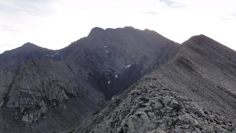  Trip reports by others had indicated a difficult knife edge to cross and a 6 foot head wall to negotiate, both shortly before the Mama Bear summit. As would be a theme on this trip, I took extremely few photos, which is very uncharacteristic of me. But focusing on the increasingly difficult terrain, route finding, and just being plain tired took the attention away from photo-opting. Thus I don't a very good pic of these obstacles, but they are about 1/4 of the way up the Mama bear summit shown below: 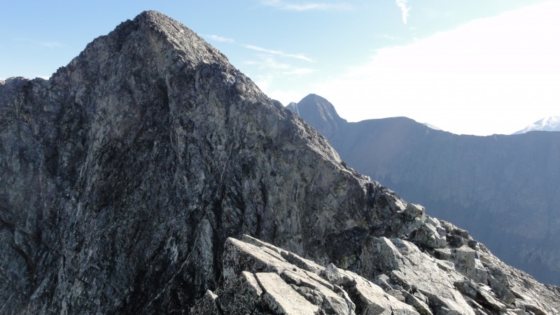 While I was relieved to not be on the standard route, in my pre-planning I had still had been plenty concerned with this alternate route. Over the years I've grown in my abilities and confidence, but just before leaving town creepy thoughts like "will this be my last beer", or "will this be the last time I kiss my wife" entered my head. After all Little Bear is supposed to be one of the 3 most difficult / dangerous 14ers. At the same time of course I was thrilled to attempt this route and couldn't wait for the day. Now that the preliminaries were over, the climbing instincts took over and it was simply a matter of going about business. Besides, as alluded to in other reports, there was an alternate way below these first difficulties. We found two ways. Tom went high, about 15 or so feet below the knife edge, I went about 50 or 60 feet below. Tom's way up high was on some sloping slabs, my way was over class 3 scrambling on somewhat loose rock. Here's two pics from my perspective down low. 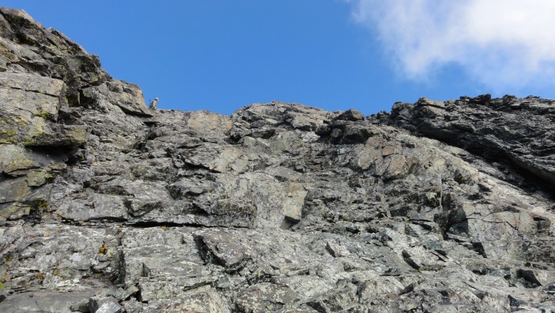 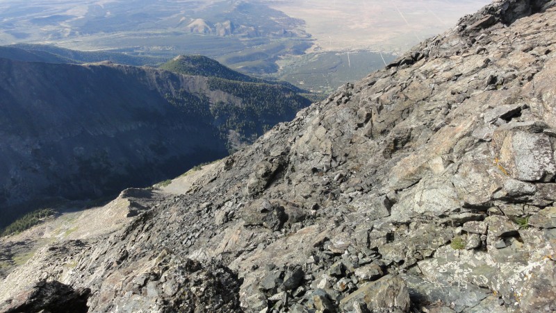 We then proceeded quickly to the Mama Bear summit. 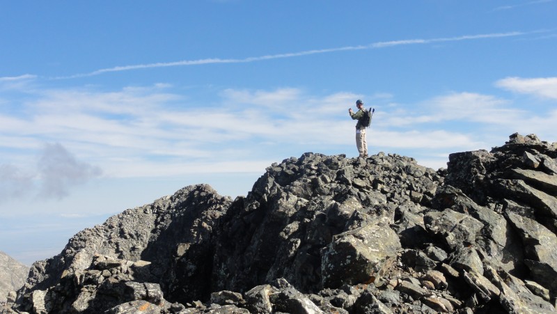   The next obstacle was a down climb off the Mama Bear summit to some ledges and to then regain the ridge. I wasn't too worried about this one prior. A simple class 3 scramble down and back up. While a slip would likely send you into a fatal tumble, it didn't "feel" quite as exposed as I had expected. Tom and I both opted for a slightly less steep down-climb adjacent to, and just before the one shown in the "FCSquid" report (see climbing notes below). 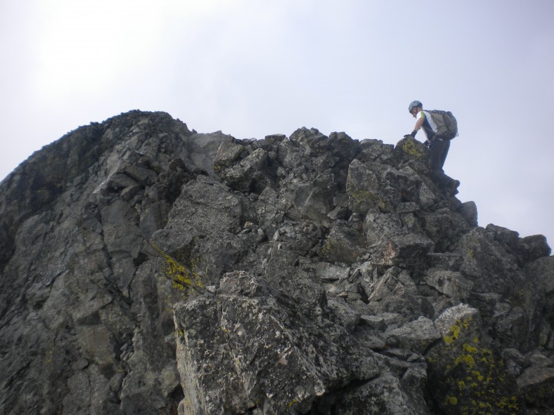 Upon regaining the ridge, it becomes quite narrow. I was leading. At first it was 4 or so feet wide, then about 2 feet wide. Absolute sheer drop off on the right of 1,000 ft or more; left side while not as bad, pretty extreme nonetheless. Directly in front it appeared that the ridge simply ended. Up to that point I know we had been on course. Did we now miss something? Was the route to keep going / down-climb on this somehow? At this point I told Tom who was right behind me, "I can't do this".  I wasn't sure myself if I meant I can't do the move, or the climb in general. We backed up a bit to a wider spot. The route was not immediately apparent. And by now I was feeling the exhaustion - already about 7 hours into the climb. We paused for a few minutes (for my sake), then took stock and looked for a way. A small ledge appeared about 30 feet down on the left side which led to a scree ramp that exited into the bowl. I hate ledges, I guess because of the exposure is so in your face, even though they are generally easy. Regardless, this ledge was not much more than a foot wide for a lot of it. About halfway across the 30 feet long ledge I paused and Tom asked something as to why I stopped. "I'm half sketched out here". "OK" Tom nonchalantly replied. I'm thinking that we went a different way than others describe as the bowl we were in was still not the hourglass bowl. Plus we didn't descend anything that resembled the class 4 down-climb pictured by others. We wound up down-climbing maybe 100 feet or more into the bowl and found a place to cross the rib that separates the hourglass bowl from the one we were in. Finally with the summit there above, it was a simple class 3 scramble to the top. We made it !   Little Bear was a summit that I really would have liked to linger on for a while. But, clouds were already moving in so we had only a short 15 min. on the summit. Though it looked like rain would develop, it never did. On the return here is a shot of Tom on the ridge:  We had one more bit of excitement for the day. At the knife edge, Tom and I both opted for the slabs 15 feet below the knife edge that he had done in the morning. The slabs had some holds and were not terribly difficult, but a slip would send you for quite a long slide. In making my way across I was testing various foot placements and pressed on a rock that I thought was part of the mountain. Not. This suitcase sized rock came free, slid over the edge and then more rocks started, and more, and more. I had been ever so careful above the hourglass not to send anything down onto climbers that were descending. That went without incident. Now, back in no-mans land I had started a full blown avalanche that went on for maybe 20-30 seconds. Three points of contact paid off on that one. With the last technical moves behind us, the rest of the hike to the car was l-oooooooooooooooooooong! I had never been so tired after a day's climb. 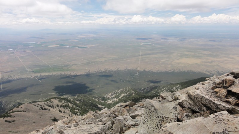 Still on the ridge below treeline, we had some fun in the woods for a brief time where Tom's magnetic compass needle pointed one way, mine pointed the exact opposite. It was Tom's compass we had used in the morning correctly, but now it completely reversed! Scary. Between a lookout point from the trees, the map, gps, etc. we made our way down. Over 15 hours! I didn't think it was possible for a 9.5 mile hike to take that long. But then again 5 years ago I didn't think I would ever climb Little Bear! Tom, thanks for joining; much more enjoyable day with you along! CLIMBING NOTES: 1) As anyone researching this route will discover, the single best source for directions and route descriptions is the well acclaimed 2010 trip report by FCSquid. Tom and I both found it very useful, along with tips from a few other trip reports also. Regarding the roads to the trail head - it is a bit smoother if when you get to the funky intersection of 18th and the diagonal Grant, take Poplar Ave. north (instead of the rougher Grant) all the way to 24th, then 24th east to the "trailhead" at the intersection of 24th and Finton. 2) As everyone attests, by all means bring a GPS. It will be most useful to find your vehicle after a long day, but also to navigate to make the crossing over Tobin Creek in the dark on your ascent. I agree that about 9,100 ft (NE from TH) is a good place to cross. The surveyors tape left from at least four different parties can be useful at times, but don't trust it too much. 3) As you read above, there are some options for route finding on this climb. If you like the sporty moves, then by all means. We were able to keep it to what I thought was class 3 all the way though if you're so inclined that way. 4) Start EARLY. The speed record so far is only 12 hours, so don't get rained out up there. Thumbnails for uploaded photos (click to open slideshow):  Moon Over Ridge (looking back)")
 First Good Look at Summit")
 Looking Back Down Ridge")
 South Little Bear Looms Dead Ahead (aka")
 Traversing Low Below the Knife Edge, Tom Up High")
 Looking Back at Low Traverse")
 Tom on South Summit, Little Bear Beyond")
 South West Ridge")
 SW Ridge, Little Bear Lake, West Ridge, Lake Como")
 From South Summit: the Traverse to Little Bear")
 Tom on a Narrow Section of the Ridge")
 View Along the Long Descent")
 Looking Back to S Little Bear from the Summit")
 Ellingwood Point and Blanca Peak from the Summit (photo credit Tom)")
 Pete on the Ridge (photo credit Tom)")
 A Narrow Section of the Catwalk (photo credit Tom)")
|
| Comments or Questions | |||||||||||||||
|---|---|---|---|---|---|---|---|---|---|---|---|---|---|---|---|
|
Caution: The information contained in this report may not be accurate and should not be the only resource used in preparation for your climb. Failure to have the necessary experience, physical conditioning, supplies or equipment can result in injury or death. 14ers.com and the author(s) of this report provide no warranties, either express or implied, that the information provided is accurate or reliable. By using the information provided, you agree to indemnify and hold harmless 14ers.com and the report author(s) with respect to any claims and demands against them, including any attorney fees and expenses. Please read the 14ers.com Safety and Disclaimer pages for more information.
Please respect private property: 14ers.com supports the rights of private landowners to determine how and by whom their land will be used. In Colorado, it is your responsibility to determine if land is private and to obtain the appropriate permission before entering the property.