Download Agreement, Release, and Acknowledgement of Risk:
You (the person requesting this file download) fully understand mountain climbing ("Activity") involves risks and dangers of serious bodily injury, including permanent disability, paralysis, and death ("Risks") and you fully accept and assume all such risks and all responsibility for losses, costs, and damages you incur as a result of your participation in this Activity.
You acknowledge that information in the file you have chosen to download may not be accurate and may contain errors. You agree to assume all risks when using this information and agree to release and discharge 14ers.com, 14ers Inc. and the author(s) of such information (collectively, the "Released Parties").
You hereby discharge the Released Parties from all damages, actions, claims and liabilities of any nature, specifically including, but not limited to, damages, actions, claims and liabilities arising from or related to the negligence of the Released Parties. You further agree to indemnify, hold harmless and defend 14ers.com, 14ers Inc. and each of the other Released Parties from and against any loss, damage, liability and expense, including costs and attorney fees, incurred by 14ers.com, 14ers Inc. or any of the other Released Parties as a result of you using information provided on the 14ers.com or 14ers Inc. websites.
You have read this agreement, fully understand its terms and intend it to be a complete and unconditional release of all liability to the greatest extent allowed by law and agree that if any portion of this agreement is held to be invalid the balance, notwithstanding, shall continue in full force and effect.
By clicking "OK" you agree to these terms. If you DO NOT agree, click "Cancel"...
"Mt. Evans?"
'The fourteener viewable from Denver?"
"No, the majestic middling thirteener by Leadville."
Poor Evans B. No Sawtooth ridge. No paved road to its summit (though a 4x4 road to nearby Mosquito Pass.) Evans B is like the plain friend to the pretty girl in the Homecoming Court, the sibling that flunks out of college. But one thing Evans A has that Evans B thankfully hasn't? Hordes of people!
It's been a frustrating winter with regard to mountaineering for me this year. No summits. So with the last weekend of winter presenting a bluebird forecast, but still some avalanche concerns, I heaved my less than svelte winter-beer-weight-body to the computer to see what kind of conservative last-minute 13er summit I could do.
Evans B. A paltry 8 miles and 2,800 feet from summitpost. A mediocre summit bid, and in tribute to mediocre 80s hair-band Great White, i sang to this little peak "My, my, my, twice orphaned, once shy, Evans." For I had twice orphaned this lesser Evans - first when I summited Sherman, Gemini, and Dyers in a half-day late-Spring romp, and second in an early-Spring tour de Tweto and pals.
Thus is born Evans B, winter warm-up.
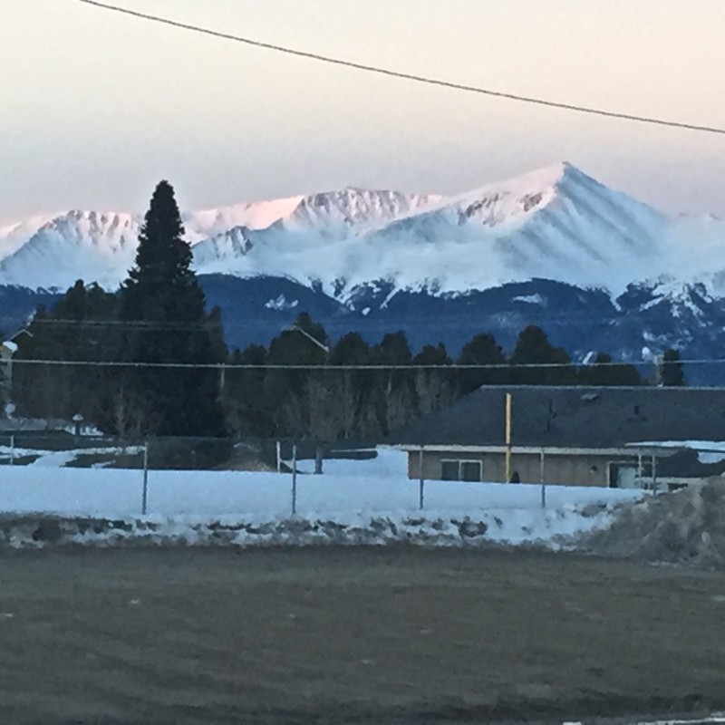
Ever wonder why anyone chooses to live in Leadville? I saw this view to the west shortly after sunrise, and I'll never wonder again:
I parked at the winter closure on Park County 3 (7th St from downtown Leadville) and hiked up the road. The road passes an old wooden mine structure on the left, and later makes a hard left at a modern day mining tower of some sort. This road gets tons of snowmobile traffic, which makes hiking it great. Shortly after the modern building, this is the view:
As the road swings widely to the south, I chose to follow a snowmobile track on a more direct eastern path. It worked well for most of the time, but then I began post-holing up to the thigh, and had to bear-crawl to a rock to strap on my snwoshoes. Shorlty after, I rejoined the road again.
Here's a view back at my crawl tracks and the panorama behind:
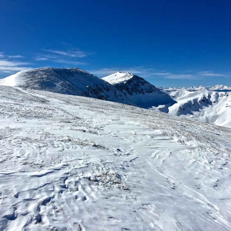
Only a few minutes after that, I had this view of Evans B ahead, with Dyer to the south.
I kept to the road as it veered northward toward Mosquito Pass and then I left the road to zig-zag southward upslope to gain the ridge leading to the radio station buildings on the lower ridge leading to Evans B. While accused of taking the path of most resistance in summer, I'm apt to find the way of least resistance in winter, so I formed my own switchbacks up this slope, keeping to where the snow was thinner and eventually finding a broad path toward Evans' north ridge.
I stopped at the building for the radio facilities to get a drink. Surveying the fairly snow-free slopes leading to Evans' summit, I decided to leave the pack and snowshoes here, and made the quick jaunt up to the summit.
Here's the view from the radio shack:
Here's the view of the final slog to the summit:
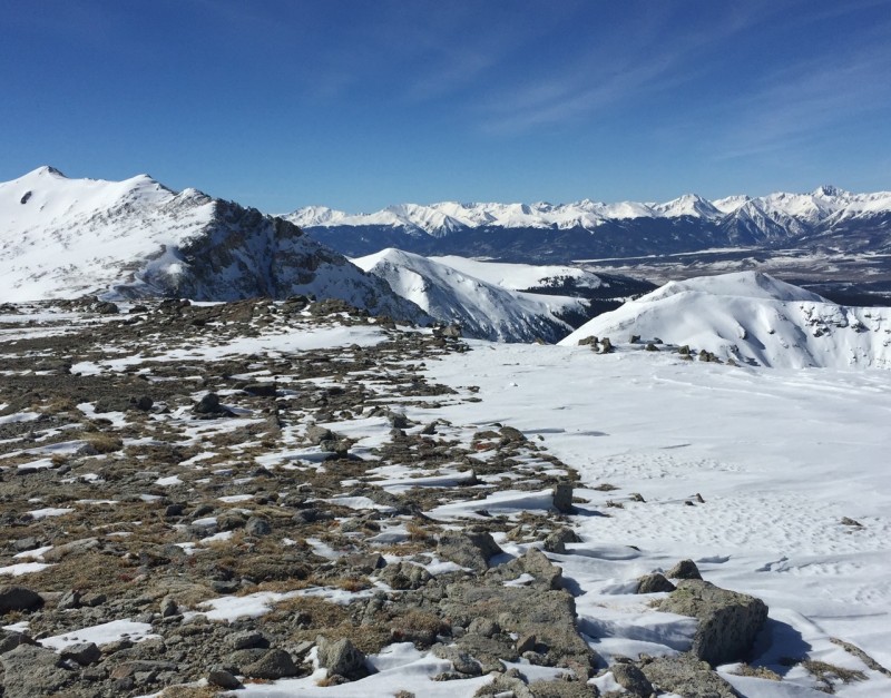
I kicked around the summit cairn, hoping to find a register. Alas, there is none, so y'all have to trust me that I stood on that hallowed ground. It was a pretty, tranquil day, and this was the view I enjoyed to the southwest:
It was a perfect, sunny, cloudless, windy day, but I lingered for only 15 minutes because I wanted to make sure to start getting down before the snow softened too much.
Here's a view north toward Mosquito, as I neared the northern edge of the broad summit area of Evans B:
It was quick, easy work to get back to the radio shack. From here, I made a tactical error that others should avoid. I contoured off the ridge proper to shortcut to the string of power lines leading up the slope from the basin. Doing so caused me to cross a slope that has potential to slide and cast you down into the basin below. The smart thing is to simply reverse the route along the flat, broad ridge. I saved little time with the detour and took on unnecessary risk.
I plunge-stepped down the slope until lower down closer, but not quite to the road, this became unfeasible and I was once more sinking past the knee. I then donned the snowshoes again, made the way to the road, and then followed it back to the car for a nice little 5 1/2 hour tour. Yes, I should have been faster. Too many IPAs, and not enough cardio in the cold, dark winter months.
But a great little winter warm-up hike, a beautiful day in the mountains, and some precious solitude.
Thumbnails for uploaded photos (click to open slideshow):
Location: Montana, United States, North America
Lat/Lon: 46.04992°N / 113.18968°W
Object Title: Mount Evans
County: Deer Lodge
the other other Evans, just saying :roll:
Evans B
it seems like so many years ago I hiked this one....
Caution: The information contained in this report may not be accurate and should not be the only resource used in preparation for your climb. Failure to have the necessary experience, physical conditioning, supplies or equipment can result in injury or death. 14ers.com and the author(s) of this report provide no warranties, either express or implied, that the information provided is accurate or reliable. By using the information provided, you agree to indemnify and hold harmless 14ers.com and the report author(s) with respect to any claims and demands against them, including any attorney fees and expenses. Please read the 14ers.com Safety and Disclaimer pages for more information.
Please respect private property: 14ers.com supports the rights of private landowners to determine how and by whom their land will be used. In Colorado, it is your responsibility to determine if land is private and to obtain the appropriate permission before entering the property.


")
")
")
")
")
")
")
")