Download Agreement, Release, and Acknowledgement of Risk:
You (the person requesting this file download) fully understand mountain climbing ("Activity") involves risks and dangers of serious bodily injury, including permanent disability, paralysis, and death ("Risks") and you fully accept and assume all such risks and all responsibility for losses, costs, and damages you incur as a result of your participation in this Activity.
You acknowledge that information in the file you have chosen to download may not be accurate and may contain errors. You agree to assume all risks when using this information and agree to release and discharge 14ers.com, 14ers Inc. and the author(s) of such information (collectively, the "Released Parties").
You hereby discharge the Released Parties from all damages, actions, claims and liabilities of any nature, specifically including, but not limited to, damages, actions, claims and liabilities arising from or related to the negligence of the Released Parties. You further agree to indemnify, hold harmless and defend 14ers.com, 14ers Inc. and each of the other Released Parties from and against any loss, damage, liability and expense, including costs and attorney fees, incurred by 14ers.com, 14ers Inc. or any of the other Released Parties as a result of you using information provided on the 14ers.com or 14ers Inc. websites.
You have read this agreement, fully understand its terms and intend it to be a complete and unconditional release of all liability to the greatest extent allowed by law and agree that if any portion of this agreement is held to be invalid the balance, notwithstanding, shall continue in full force and effect.
By clicking "OK" you agree to these terms. If you DO NOT agree, click "Cancel"...
First, I will provide detail about finding the start of the route up the NW Face of Little Bear which seems lacking in other reports.
Second, I will detail a descent off of Ellingwood point which makes a nice aesthetic finish to a traverse of the ridge connecting these three peaks without doing the entire SW Ridge of Ellingwood which, IMO, has a somewhat unpleasant scree field for the last 1/3 of the descent. This report will describe the S Gully which was straightforward and saves both time and effort from other descent routes.
A little background. I had attempted the NW Face of Little Bear two years ago and based on beta from this site and the Roach guide I ambled up to, and poked around to the right of, the Black Hand. There were several lines that seemed like they would go somewhere, but were pushing into 5th class and disappeared from view. After poking my head into several places where I would not want to down climb I abandoned the attempt, settling to climb Blanca and Ellingwood Point.
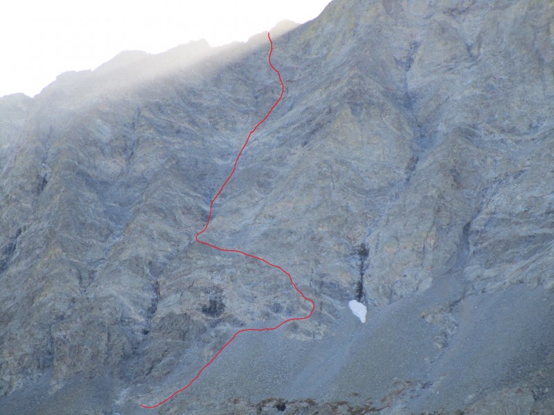
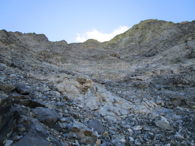
Fast forward to the weekend of 9/10/16. After visiting familiar places where I did not want to be, I ventured far to the right of the Black Hand, far enough to the right that I could see the snow in the following image. If the snow is melted out, the black watermark would also just be coming into view from the point where I began my ascent from the scree field. These show how far from the Black Hand you should go before moving up the wall.
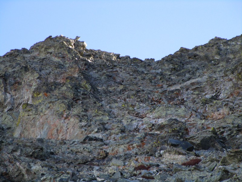
The crux to getting started presents as a mantle move but which can be negotiated more easily be moving out of the shallow dihedral to the right and climbing directly over the face. Once on fairly typical 3rd class terrain for as far as the eye can see it is time to move deliberately back to the left and settle into the main gully of the NW Face. The following photos depict the view looking back towards the start of the climb from where the main gully is accessed and then a view up the face from the same spot.
After scrambling up the low angle 3rd class section there appear to be a variety of possible exits. Generally, the access to the ridge further along toward Blanca looked less severe than lines closer to a direct line towards the summit of Little Bear. I opted for middle ground angling slightly left of straight up.
The following image is looking at options to the left.
And then the steeper headwall section to the right.
Next is a view looking down the face from the top of the class III section before committing to a line to get past the headwall
Getting close to topping out the final push to the summit of Little Bear is in full view. Here I crossed paths with someone descending from the summit about to start the traverse to Blanca.
A look down from the ridge from where I topped out.
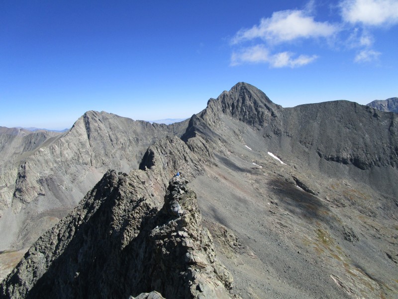
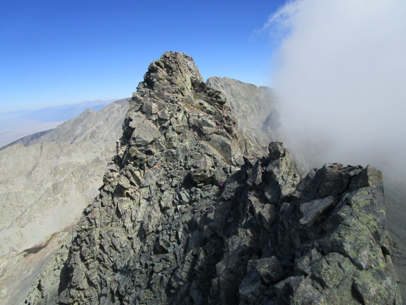
A nice view of the entire traverse to Blanca.
I think the crux of the entire LB/B traverse is this problem which is the first bump along the way once off the summit of LB and on the ridge proper. I got to climb it twice, going up to tag the summit of LB and then again on the return to complete the traverse. It was easier going up because coming down was sort of blind. But it seemed easier than the option of going around. The difficulty was similar to the crux move to get to the summit of Mt. Wilson if that move is done on the more exposed south side. The next photo is a look up at this problem.
Crux of the LB/B Traverse?
Finally, coming back from the summit of Little Bear, the next photo shows my pack where I topped out from the NW Face. It shows the last few moves to gain access to the ridge and the only difficulties on the entire face, other than the start.
Spy the purple pack in the center of this photo
OK, there are plenty of reports on the traverse itself, so I will not add to that. We turn our attention now to Ellingwood Point and a descent that I have not seen described elsewhere.
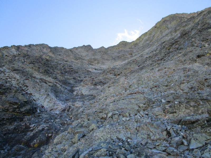
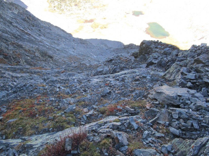
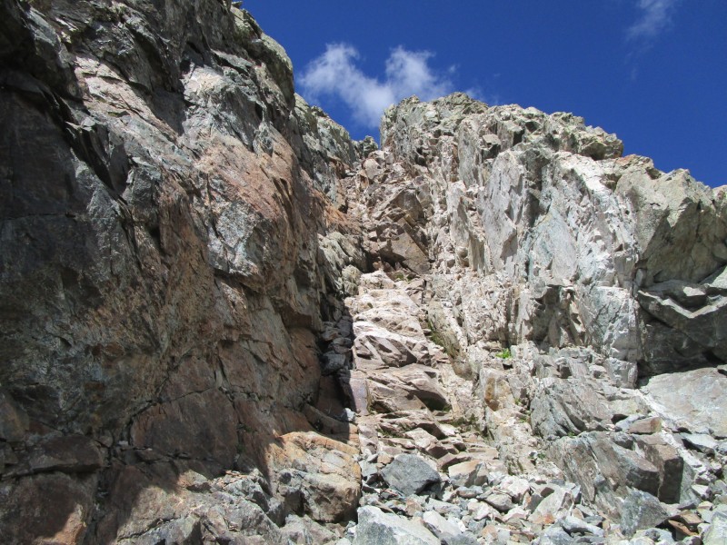
Starting down the SW Ridge a prominent red gully will present itself after just a few minutes dropping off to the south. It begins, probably in less than 500 yards from the summit. From the crest of the SW Ridge it cannot be discerned if this gully will cliff out or not, so dropping in after a long day was a tad risky. But a long story short, this gully was a fantastic descent. It was fast and the footing was excellent, by scree standards. There was one awkward move at the bottom, but it was not terribly exposed or complicated. For people who like ratings, I would say it was 20' of class IV, but only to avoid being called a sandbagger.
I will let the photos tell the rest of the story. Next time you are up there, check it out. I have been on the SW Ridge 3 times, twice down and once up, and I would have to say that this makes a nice alternative for a descent.
Caveat - NOT RECOMMENDED FOR LARGE PARTIES. HUGH POTENTIAL FOR KNOCKING ROCKS LOOSE. I would also suggest that this might not make a great ascent route as the loose rock that makes it fun to descend would make it lots of work to climb up.
Ellingwood Point from the Ellingwood/Blanca saddle
South Gully of Ellingwood Point
The final 20' at the bottom of the gully.
Scree to the trail below.
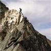
On the hike out I took another look at the Black Hand and the false start that lured me in twice. Someone out there might make this go, but there is an easier way!
This line is tempting, but don't go here.
Thumbnails for uploaded photos (click to open slideshow):
1. How was the rock quality on the NW Face? It looks quite loose in some pictures.
2. Have you done the Hourglass route? If so how does this compare in terms of difficulty as well as rock quality. (I.E. would you advise this route to those looking to avoid the hourglass).
I have done the hourglass a couple times. The NW Face is more difficult both in terms of technical skill required and route finding. The loose sections on the NW Face are all in the walk up class III sections. The steep moves at the bottom and top are on solid rock. Of course, that is a relative term. Holds can blow out, but generally seems pretty solid. Hourglass, in the technical section, is better rock but the same loose crap at the top which people worry about, rightfully so, when there are people above them. Also, difficulty in the Hourglass can usually be minimized by hanging on the ropes (no, I didn't touch them) that hang there or can be climbed just to the left on generally class III rock.
MadDadMike did that descent in winter off Ellingwood?? I took one look at it this last early March and thought I'd stick with the devil I knew and back up and over the saddle to Blanca. But sometimes the devil you don't know is a might fine dance. Nice work! The NW face of LB is the best way to get up that beast.
A friend and I climbed it the next day, up the nw face and down the hourglass. We went directly right of the black hand and just figured it out. Definitely steep so thanks for the picture that says 'no'. Gave me a good laugh and definitely got the adrenaline flowing.
Caution: The information contained in this report may not be accurate and should not be the only resource used in preparation for your climb. Failure to have the necessary experience, physical conditioning, supplies or equipment can result in injury or death. 14ers.com and the author(s) of this report provide no warranties, either express or implied, that the information provided is accurate or reliable. By using the information provided, you agree to indemnify and hold harmless 14ers.com and the report author(s) with respect to any claims and demands against them, including any attorney fees and expenses. Please read the 14ers.com Safety and Disclaimer pages for more information.
Please respect private property: 14ers.com supports the rights of private landowners to determine how and by whom their land will be used. In Colorado, it is your responsibility to determine if land is private and to obtain the appropriate permission before entering the property.


")
")
")
")
")
")
")
")
")
")
")
 Crux of the LB/B Traverse?")
 Spy the purple pack in the center of this photo")
 Ellingwood Point from the Ellingwood/Blanca saddle")
 South Gully of Ellingwood Point")
")
")
 The final 20' at the bottom of the gully.")
 Scree to the trail below.")
 This line is tempting, but don't go here.")