| Report Type | Full |
| Peak(s) |
Blanca Peak - 14,350 feet |
| Date Posted | 10/27/2016 |
| Date Climbed | 07/22/2016 |
| Author | hessma |
| The Spark that Ignited the Fire |
|---|
|
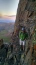
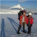
In 1998 I accepted an invite to come to Colorado for a hunting trip in the San Luis Valley. We didn't bag any elk that year, but I did spend a lot of time hiking around the south west skirt of a mountain I would come to love, Blanca. On the last day of the hunt, I hiked as high as I could comfortably go along a steep ridge just below Little Bear. It was one of the most memorable mountain experiences of my life. It wasn't until years later that I began to really contemplate summiting 14ers, and decided that Blanca had to be my first. I've struggled with weight and health issues for many years in my life. Part from a family history of weight issues, part from focusing on school and career while neglecting health. After several failed attempts at weight loss, I bit the bullet and had gastric bypass surgery. That was a little over 2 years ago. I spent most of the past 2 years working on health, fitness, and nutrition. This year I decided it was time to try Blanca. My best friend and I (he is also a gastric bypass patient) began making plans early in the year. We bought gear for backpacking, spent time in the backcountry trying things out, and hiked. On his last week here in Colorado we went for Blanca. I had been on Como Lake Road several times in the past and knew the dangers of the road. The plan was to take the Jeep just past Jaws .5, park in the large open turnout to the right, and then to hike to Como Lake for camp. The Jeep did fine, and there were plenty of spots to park on a Thursday. It had been years since I last visited Como Lake Road and some things have changed. There are now several parking/camp spots heading up the road and before Jaws 1. If you can make it to the large lot we parked in, chances are you can make it all the way to Jaws 1 to park. The large parking area is by far the safest bet though in terms of availability if you are planning on driving up the road. Before long we were up the road and settling in at Como Lake. The weather forecast called for afternoon showers, so we got on the trail at a decent morning hour and headed up towards the upper lakes. We planned to do the standard Northwest Ridge route to Blanca, and if all went well, we would attempt Ellingwood. The hiking proved to be difficult for my partner who had come from sea level in Houston. Just above Crater Lake he decided he did not want to go any further and we had a discussion about my continuing ascent. I had done quite a bit of research on this website regarding the route and the "do's/don'ts". I knew that leaving my partner was a risk. There were two people above us heading up the saddle to Blanca and we recognized them as a duo we had met the day prior near camp. We knew they were also doing Blanca on the standard route so we discussed a plan to communicate with the other hikers if we crossed paths, and set some basic time frames for escalation if things went wrong. Once the plan was decided, I set out to reach the summit. Like a man on fire I made my way to the ledges. It wasn't long before I had made my first known mistake of the day. Soon after crossing a semi-permanent snow field, I made a left too early. It may have been the Ellingwood route, I'm not sure, but soon I lost the cairns. Looking back, I should have followed the trail all the way to the right, near the rock wall below Blanca, before making the steeper ascent. Once I knew I was off trail, I broke out my trusty 14ers website pics and route description. I realized I needed to head up towards the saddle to pick the trail back up. This was a bit steeper than I had bargained for, but at no time did I feel it was too difficult as the rocks were solid and the holds were strong. I eventually came to a ledge wall with a small waterfall. Once I was above this water wall, I went as far right as I could while continuing to climb up. More scrambling off trail until finally, CAIRNS!!! I actually yelled it out loud which felt strange since I was alone. Once I was back on trail my confidence was high. I soon made the saddle and took a break. It was a breathtaking. The view in every direction topped anything I had seen before. While waiting, I encountered another hiker who was going solo. After a quick high 5 (hiker hello?) we began to chat about his climb. He was doing well, but a bit shaken because he went too far to the left of the ridge and found himself doing some sketchy climbing. We discussed his ascent and he advised me to stay far to the right as I get closer to the summit. I asked him to check in with my friend if he encountered him below and to let him know I was still climbing. I came across the hikers from camp soon after my chat with the first hiker. More high 5's/fist bumps. More route advice and a request to check in with my friend. Then, I was alone. Just me and the remaining summit route. I tried to stay right but near the bulge just below the peak I lost the cairns and any sign of the trail again. I wasn't comfortable going far right because I could not see a path forward and it seemed to drop too low to the right of the summit. I began to make my way back closer to the ridge, staying as far right as I could, but eventually riding the ridge. The final stretch was difficult, but taking my time, talking myself through the sketchy parts, and keeping my focus made it not only do-able, but extremely enjoyable. Soon I was on top. I spent some time exploring, remembering why I was there, and looking at Little Bear, Lindsey, and Ellingwood for future reference. I snapped a couple of crappy photos with a really bad flip phone, and these were the only photos of the trip. This trip was special, and on the really special trips, I tend to take fewer pictures. Not sure why. There was no registry, but there was a small American flag with names on it. I signed the flag, took one last look around, and headed down towards the descent. Heading down I took a slightly different route. I remembered the 1st hiker telling me to look for hard pack where others had gone and I saw a faint trail just down and to the left of the summit shelter. That trail seemed to take me to the left of the bulge below summit. It was steep, and I had to slide some until I came to the bottom of the bulge. I gingerly made my way around the base of the bulge and eventually found the cairns which took me right back to the point I turned left, bailing on the trail and heading for the ridge during my ascent. Not sure which would have been harder, climbing the steep/loose hard pack, around the bulge, or riding the ridge. The rest of the descent was a slog, but the trail seemed much easier to follow. I could see the cairns much easier and this is where I realized the "mistake" I made early in the hike by short cutting the trail during the climb. I reunited with my pal back at Crater Lake. We made it back to camp and soon after we had a massive hail, rain, and lightning storm. It flooded our campsite with 4-6 inches of hail and a ton of water. Our gear was solid and stayed dry, so we moved our tent to higher ground. and settled in for another awesome night of camping. As an fyi, if it is going to rain, I don't advise using the campsite to the right of the 1st shelter shack after entering the Como Lake campgrounds. The campsite is close to both the outlet stream and lake and sits next to the long rock wall. It's a funnel point for water going to the creek. Since this first climb I have summited 4 other 14ers this year. I plan on doing many more and hope to see you all on the trail.  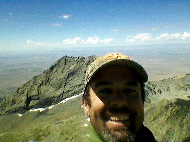   Thumbnails for uploaded photos (click to open slideshow): ")
")
")
")
|
| Comments or Questions | |||||||||
|---|---|---|---|---|---|---|---|---|---|
|
Caution: The information contained in this report may not be accurate and should not be the only resource used in preparation for your climb. Failure to have the necessary experience, physical conditioning, supplies or equipment can result in injury or death. 14ers.com and the author(s) of this report provide no warranties, either express or implied, that the information provided is accurate or reliable. By using the information provided, you agree to indemnify and hold harmless 14ers.com and the report author(s) with respect to any claims and demands against them, including any attorney fees and expenses. Please read the 14ers.com Safety and Disclaimer pages for more information.
Please respect private property: 14ers.com supports the rights of private landowners to determine how and by whom their land will be used. In Colorado, it is your responsibility to determine if land is private and to obtain the appropriate permission before entering the property.