Download Agreement, Release, and Acknowledgement of Risk:
You (the person requesting this file download) fully understand mountain climbing ("Activity") involves risks and dangers of serious bodily injury, including permanent disability, paralysis, and death ("Risks") and you fully accept and assume all such risks and all responsibility for losses, costs, and damages you incur as a result of your participation in this Activity.
You acknowledge that information in the file you have chosen to download may not be accurate and may contain errors. You agree to assume all risks when using this information and agree to release and discharge 14ers.com, 14ers Inc. and the author(s) of such information (collectively, the "Released Parties").
You hereby discharge the Released Parties from all damages, actions, claims and liabilities of any nature, specifically including, but not limited to, damages, actions, claims and liabilities arising from or related to the negligence of the Released Parties. You further agree to indemnify, hold harmless and defend 14ers.com, 14ers Inc. and each of the other Released Parties from and against any loss, damage, liability and expense, including costs and attorney fees, incurred by 14ers.com, 14ers Inc. or any of the other Released Parties as a result of you using information provided on the 14ers.com or 14ers Inc. websites.
You have read this agreement, fully understand its terms and intend it to be a complete and unconditional release of all liability to the greatest extent allowed by law and agree that if any portion of this agreement is held to be invalid the balance, notwithstanding, shall continue in full force and effect.
By clicking "OK" you agree to these terms. If you DO NOT agree, click "Cancel"...
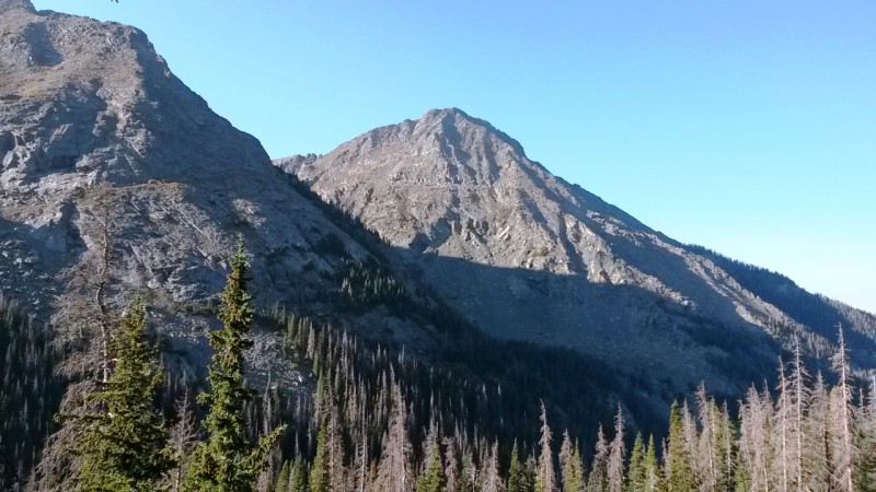
Took the Cottonwood Creek approach to Crestone Peak and had an awesome time. Not sure if I can add any beta but maybe some comments and opinions. One thing for sure is the Cottonwood Creek approach is gorgeous, especially once you take the left hand drainage towards the Cottonwood Lake basin. Add in a gorgeous early September day (with no afternoon t-storms) and my bro Tommy and my first class 3 success was amazing!
We left the trailhead at 4:30AM to get a head start. The first 3 miles up the Cottonwood Creek trail are straightforward. Over the next mile, as you hit the 'Boilerplate Slabs' section (phrased coined by Roach and mentioned in other TRs for this route), it is still quite easy to follow the cairns. And almost all of the deadfall (mentioned in older TRs) is cleared out for easy passage.
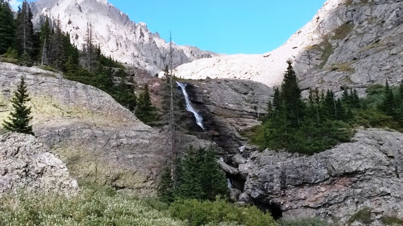
Cool waterfall on the way up Cottonwood Creek TrailThe entrance to the Boiler Plate slabs.. creepy root!!The Boiler Plate slabs... if dry --> no problemvery interesting rock those Boiler Plate slabs are
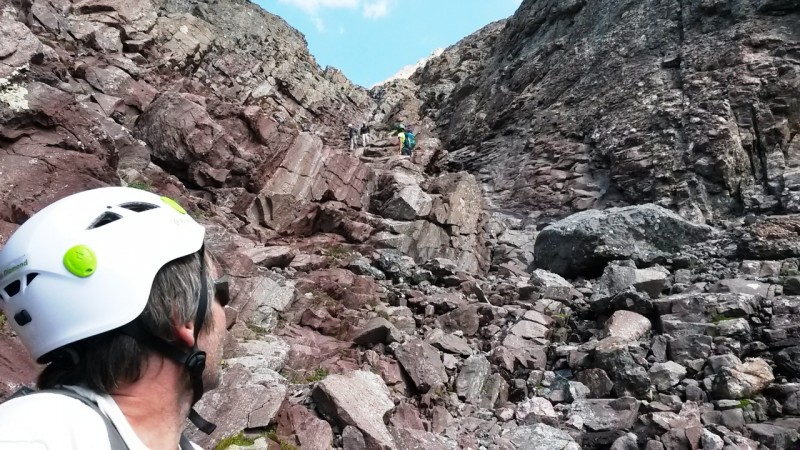
We met some really cool campers at about the 4 mile mark as we finished passing the 'Boilerplate Slabs' section. This was about the section where you take the left drainage towards the Crestones (vs staying right towards Milwaukee Peak). The campers mentioned that once you turn up into this next drainage, that it is basically a section of 3 waterfalls up to the Cottonwood Lake area / basin. We decided to call this the 'Waterfalls Section'. The terrain becomes very steep as you begin this section. You will see on the gpx track that there is a bit of a circle as the trail turns left. This is because this is the only way to get up the steepness.
Basically the 'Waterfalls Section' is 3 cliff bands that you have to navigate up and around. The trail is sparse and there are different options. In the end though, stay left of the creek and keep going higher in the drainage! You can navigate the slabs closer to the waterfalls or rock hop through steep wooded area to the left of the slabs.
No matter which way you go through the 'Waterfalls Section' it is all fun rock scambling. Previous reports / threads discuss whether to go way high on the talus fields to the left to avoid the willows between cliff bands (and even some of the bands themselves). We felt that would have cost us a lot more energy with the trek up the Red Gully still in front of us. So, we stuck as close to the left of the creek as possible... there was a little bit of willow-bush-red-sea-parting goin' on, but wasn't really bad.... there's kind of a small trail underneath a lot of those willows.
Looking up the first of the 3 waterfalls in the 'Waterfall Section'Views to the South as you make your way towards the basinThe second and coolest looking waterfall in the "Waterfall Section". This photo taken on the way down (mid-afternoTommy navigating some of the steep slabs to get up the "Waterfalls Section"Looking down from the 2nd waterfall in the "Waterfalls Section"As you near the finish of the cliff bands / "Waterfalls Section".. finally and WOW!!! You are staring at the might
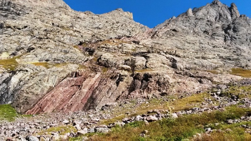
After about 5 miles you connect with standard trail to Crestone Peak. Off topic, but we did happen to see a large man sleeping on the side of the trail (no tent or anything.. just passed out in the grass). Certainly a nice place for a nap, but a bizarre scene in terms of the context? Anyway, it is just stunning to see the Peak and the Needle for the first time!! And this tidbit... if you are are taking this route and only heading straight to the Peak, you will actually never see Cottonwood Lake. It is just one quick detour if you want to run over and see it... but this is the case.
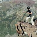
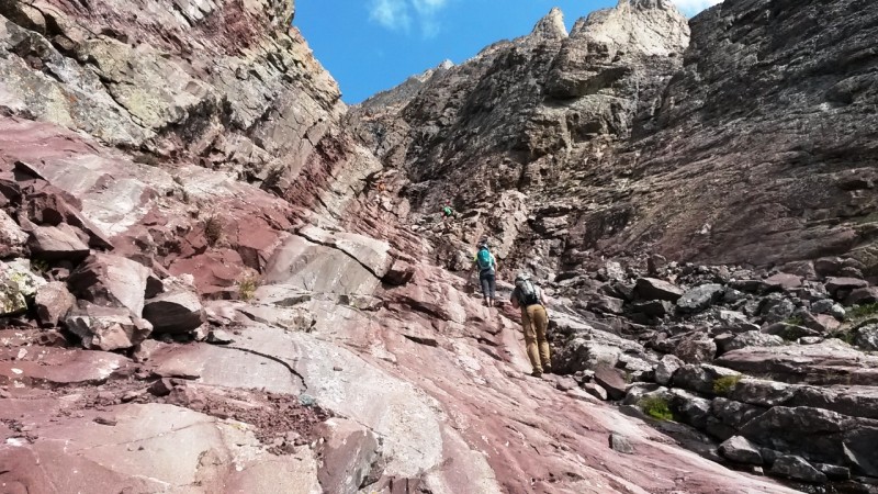
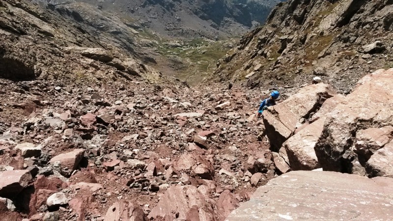
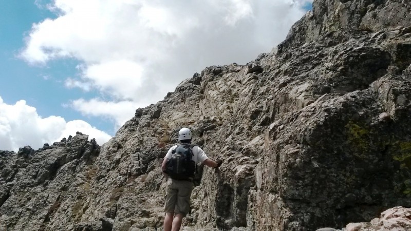
The Red Gully and the summit block are just insane. We took our time and steadily made it up the gully. The rock in the gully is mostly solid but there are some loose spots to watch out for. Ran into a a really nice couple from Maryland (like me) who had moved out to Colorado just to be able to climb mountains!! (Me --> jealous, and told them so). The summit block was great stable rock, and while airy, not bad at all. Near the summit, we met these two young guys who were like mountain goats. They had taken Ellingwood Arite up the Needle, then made up their own variation of traverse from Neede to Peak but staying more on the ridge. These kids were basically crazy and we told 'em to please be careful!
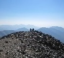
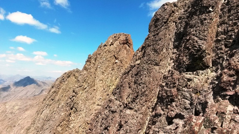
First up close of the Red Gully!!Getting closer to the Red GullyStarting up the Red Gully. We met these cool folks (pic'd here) from Maryland (oh, that's where I'm from!)...The Red GullyTommy looking up the Red GullyThe Red GullyLooking down part way up the Red GullyThat's me in the Gully!Gettin' steep!Looking down from the top of the Red Gullyfrom the saddle, looking towards the summit block... the true summit is beyond this apparent summit... but not farCool view to the SouthLooking North to Kit Carson and Challenger Point from the saddleNortheast CrestoneTommy looking over the route up the summit blockAlmost there! A couple of cool cats were already hangin' on top!Pulling my way over the final rock!! Awesome pano from the top!East Crestone from the toppure ruggedness.... awesome!We did it!!Love this view to the valley to the West... looks like space to earth or somethingThe bad boy NeedleHooray! We're on top of Crestone Peak!more cool panosNortheast Crestone, East Crestone and Crestone Needlenot sure but might be Humbolt in the background?The Needle and beyond!
Given it was our first successful class 3 14er, I'm sure you can imagine after 6+ miles one-way and close to 6000K elev gain, we were feelin' pretty stoked to be sitting on that summit!!
If you are looking to take a less traveled 14er route and can deal with a little extra length and ascent, this route is really fantastic. It was an epic adventure for Tommy and me and a day we both agreed we would remember for the rest of our lives.
***So here are some thoughts relating to beginning into class 3s in general. I would say I DO think this is a fairly decent choice for someone looking to do their first class 3. Now I caveat that with the fact that you do need to be in decent shape as that trek up the gully itself is long! (It took us 2 hours to go up and 2 hours to come down just the gully itself!) ... but, the thing that is nice is that there really isn't huge exposure. There are spots where if you fell, you could get banged up real bad and could even die, so obviously you have to be careful. But even the summit block itself, if you stay to the ridge a bit and go for a slightly harder climbing move, you completely bypass the 1000 ft drop-off type of exposure I would imagine you normally see on class 3 routes. Even something like Kelso Ridge (which spooked me into turning around) has (I think) more exposure than this route. Something to think about if you want to try a class 3.***
The way down was long and painful as most way downs are... Those last 3 miles really hurt once you are on a somewhat boring trail after having seen the insanity we saw earlier... UUUggggghhh. Total stats 13.25 miles RT, 15 hours (yes, we're slow old geezers .... but we were also taking the time to enjoy the sites!), 5800+ elev gain
My GPS Tracks on Google Maps (made from a .GPX file upload):
Thanks for the trip report, this route to Crestone Peak has been on my long list for a while as a backpacking trip. After seeing your pictures and report it went to the top of the list, I'll have to try it soon!
...is the peak in the background of your one pic. Humboldt is hiding behind East Crestone. Nice job & a great TR (your 1st?)!
Trotter - Andrea & I had discussed coming up the Cottonwood approach, camping, & going for Crestolita & the other 13ers in that area in a year or 2... I'll let you know!
*Edit... I see your other reports now. Nice job, nonetheless!
Caution: The information contained in this report may not be accurate and should not be the only resource used in preparation for your climb. Failure to have the necessary experience, physical conditioning, supplies or equipment can result in injury or death. 14ers.com and the author(s) of this report provide no warranties, either express or implied, that the information provided is accurate or reliable. By using the information provided, you agree to indemnify and hold harmless 14ers.com and the report author(s) with respect to any claims and demands against them, including any attorney fees and expenses. Please read the 14ers.com Safety and Disclaimer pages for more information.
Please respect private property: 14ers.com supports the rights of private landowners to determine how and by whom their land will be used. In Colorado, it is your responsibility to determine if land is private and to obtain the appropriate permission before entering the property.


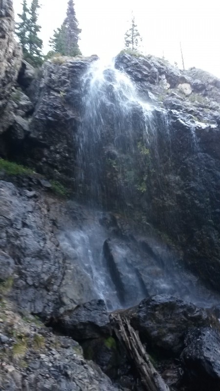


 Cool waterfall on the way up Cottonwood Creek Trail")
 The entrance to the Boiler Plate slabs.. creepy root!!")
 The Boiler Plate slabs... if dry --> no problem")
 very interesting rock those Boiler Plate slabs are")
 Looking up the first of the 3 waterfalls in the 'Waterfall Section'")
 Views to the South as you make your way towards the basin")
 The second and coolest looking waterfall in the")
 Tommy navigating some of the steep slabs to get up the")
 Looking down from the 2nd waterfall in the")
 As you near the finish of the cliff bands /")
 First up close of the Red Gully!!")
 Getting closer to the Red Gully")
 Starting up the Red Gully. We met these cool folks (pic'd here) from Maryland (oh, that's where I'm from!)...")
 The Red Gully")
 Tommy looking up the Red Gully")
 The Red Gully")
 Looking down part way up the Red Gully")
 That's me in the Gully!")
 Gettin' steep!")
 Looking down from the top of the Red Gully")
 from the saddle, looking towards the summit block... the true summit is beyond this apparent summit... but not far")
 Cool view to the South")
 Looking North to Kit Carson and Challenger Point from the saddle")
 Northeast Crestone")
 Tommy looking over the route up the summit block")
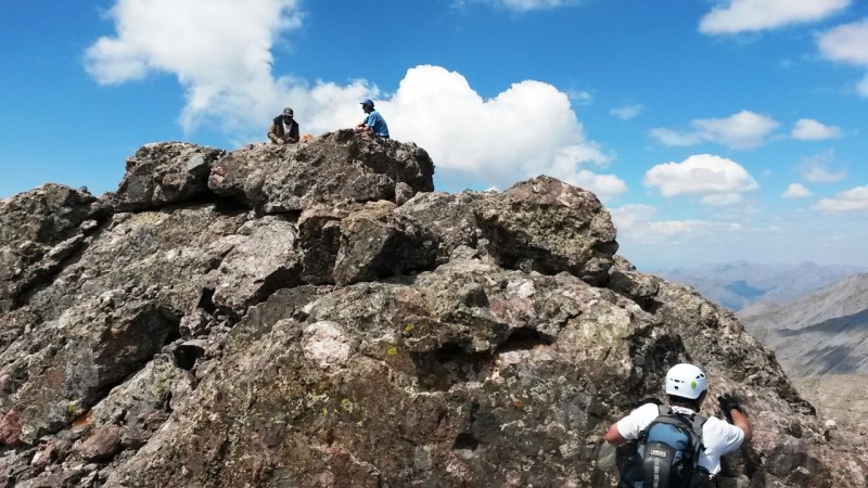
 Almost there! A couple of cool cats were already hangin' on top!")
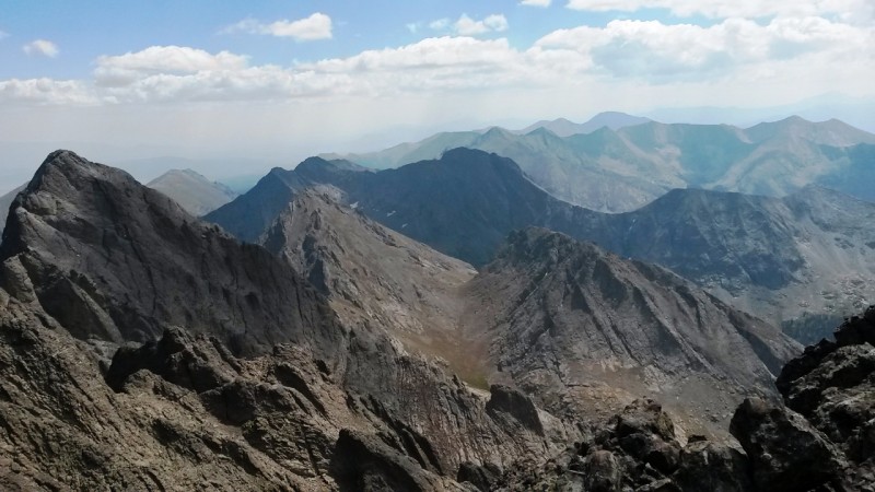
 Pulling my way over the final rock!! Awesome pano from the top!")
 East Crestone from the top")
 pure ruggedness.... awesome!")
 We did it!!")
 Love this view to the valley to the West... looks like space to earth or something")
 The bad boy Needle")
 Hooray! We're on top of Crestone Peak!")
 more cool panos")
 Northeast Crestone, East Crestone and Crestone Needle")
 not sure but might be Humbolt in the background?")
 The Needle and beyond!")