| Report Type | Full |
| Peak(s) |
Aconcagua - 22841 |
| Date Posted | 02/01/2018 |
| Date Climbed | 01/12/2018 |
| Author | emcee smith |
| Aconcagua Normal Route |
|---|
|
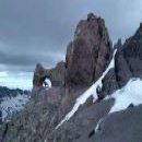
Aconcagua Normal Route Report is broken down as follows: - Stats - Day by day of what we did and some of how I felt - General health of the group - Gear thoughts - Guide thoughts Original and Actual Schedule (no weather delays) with approximate miles and elevation gain December 29: Mendoza to Penitentes Trail Day 1-December 30: Penitentes to Confluencia (5 miles; 1,600ft gain) Trail Day 2-December 31: Day hike to Plaza Francia; return to Confluencia (9.7 miles; 2,500ft gain) Trail Day 3-January 1: Confluencia to Plaza de Mulas (12.8 miles; 3,500ft gain) Trail Day 4-January 2: Rest day at Plaza de Mulas Trail Day 5-January 3: Day hike to Mt. Bonete; return to Plaza de Mulas (6.9 miles 2,300ft gain) Trail Day 6-January 4: Carry to Canada; return to Plaza de Mulas (3.3 miles; 2,250ft gain) Trail Day 7-January 5: Rest Day at Plaza de Mulas Trail Day 8-January 6: Move to Canada (1.9 miles; 2150ft gain) Trail Day 9-January 7: Move to Nido de Condores (1.7 miles; 1,650ft gain) Trail Day 10-January 8: Rest day at Nido Trail Day 11-January 9: Move to Colera (1.5 miles 1,470ft gain) Trail Day 12-January 10: Summit and return to Colera (6.3 miles; 3,250ft gain) Trail Day 13-January 11: Descend from Colera to Plaza de Mulas (3.2 miles; 5,250ft descent) Trail Day 14-January 12: Descend from Plaza de Mulas to Penitentes (16 miles; 5,000ft descent) A trip to Aconcagua along the normal route with Alpine Ascents International. Note that we had porters moving our group gear and all of us utilized porters to an extent up and down the mountain for 10kg of personal gear. All my notes and thoughts are with a 20-35lb pack weight each day. I found this picture of the upper route from Inka Expeditions. It shows the rough route and the approximate locations of each camp. 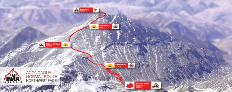 Around May 2017 I decided that this would be the year to attempt Aconcagua. My wife and I had recently moved back to Colorado, I would be able to do quite a bit of hiking/training during the summer, and my overall work schedule seemed to be accommodating to that type of a trip. I knew I would be going with AAI as I had utilized them for Kili; the schedule over the Christmas holiday allowed me to minimize vacation time and disruption at work. Throughout the spring and summer, I focused on (1) carrying weight on my hikes, and (2) trying to incorporate my new mountain boots (La Sportiva G2SM) as much as possible. By mid summer I was comfortably carrying 30-35lb on my hikes and wearing my boots when it wasn't too warm. Felt good on the training, concerned about my feet and the boots. At some point around August, I read something that said effectively, "if you are training for a mountain and all you are doing is hiking, you need to modify". At this point I subscribed to the Uphill Athlete training program which incorporated a lot of slow running, weight training, and early on, surprisingly little hiking. By early December, I was hiking back to back days on the weekend, in my boots, with weight. Overall I appreciated the training program and it certainly was better than just hiking a bunch. As trained up as I would get, my wife and I travelled to Mendoza Argentina on the 22nd of December, arriving on the 23rd. Denver - Houston - Santiago (Chile) - Mendoza. Flying United/LATAM I was able to check bags all the way through to Mendoza. My bags were delivered to the oversize area in Mendoza which is across the terminal from baggage claim so a little bit of distress quickly resolved. We stayed at the Park Hyatt which was a very nice hotel and centrally located on the Plaza Independencia. Within 2-3 blocks from the square were at least a half dozen gear shops, a grocery store, etc. so I was able to get a few last minute things. After a nice Christmas, I put my wife back on a plane on the 27th and met my group on the 28th. Much like any town, things were not open on Christmas eve and day, so we spent quite a bit of time at the pool. Now with the group, we did a typical gear check and background discussion. They wanted to understand everyone's experience on crampons and my time in CO wasn't that impressive to the guides and the group. I had done the Angel of Shavano, Snowmass, Quandary in the winter, and St. Mary's. I felt that I had plenty of experience for the Normal Route on Aconcagua, but others had been to Rainier, Elbrus, and Denali. In the end, I (and the guides) felt my crampon/snow skills were up to par. Since we aren't roping up, no glacier travel, it really is mostly about being comfortable walking with crampons and not tripping. We handed our permit fees to our guides at the hotel, and they took care of the permits without us. So our morning on the 29th was pretty leisurely and by mid-morning we boarded the bus to Penitentes. I was a bit concerned with getting motion sickness but the road up to the mountain was pretty tame and I felt fine. We arrived in Penitentes and checked into the Aleyen Hotel which was a nice lodge style hotel that serves skiers in the winter and climbers in the summer. Dinner in the large dining hall was nice; interesting to see climbers coming and going. The next day we "leisurely" travelled to the entrance to the park. Given a limited number of guide services and more groups, we had to wait our turn and were one of the later groups to leave. We dropped our big duffels to the mules, a small duffel to be stored (clean clothes for the return), checked into the park and were on our way. 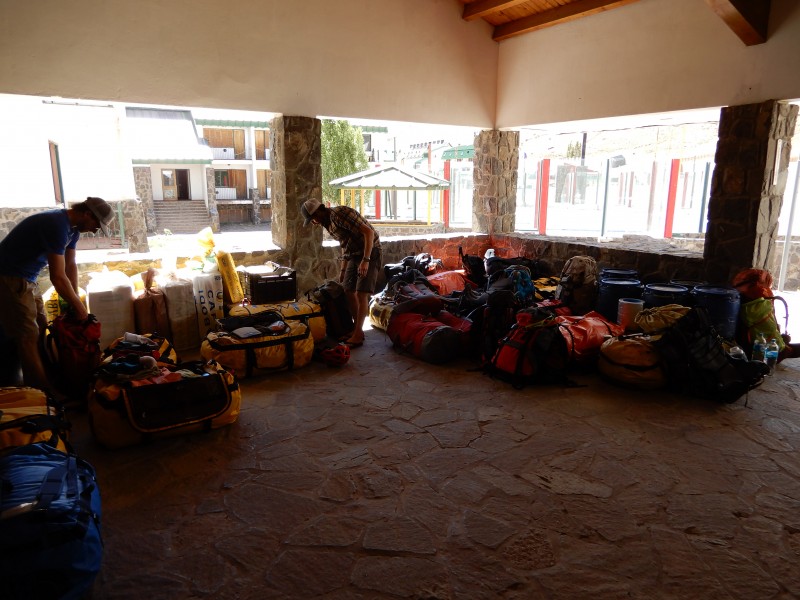 NOTE: All distances, times, elevations approximate based on GPS watch readings and our particular camp sites, etc. The elevations of the camps are from the information the guides gave us. They don't necessarily match up. Day 1: Penitentes (9,350') to Confluencia (10,826') 5 miles; 2:30 moving time; 1,600ft of ascent Our first walking day, from the park entrance to Confluencia was a pretty easy trip. The first part of the hike is through the park proper; you can see Aconcagua from the trail, but there are quite a few tourists. After the first bridge across the river (maybe 1 mile in), the tourists drop away and mostly climbers remain. 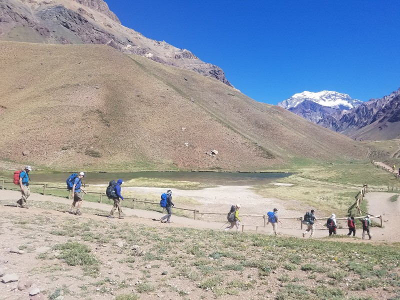 This shot shows some of the trail to Confluencia. This was a relatively rugged bit of trail, we wouldn't see the wide river plains until on the walk to Plaza de Mulas. This section of the trail felt like many of the Colorado 14ers above tree line. Not too rugged but still trail and still gaining elevation. 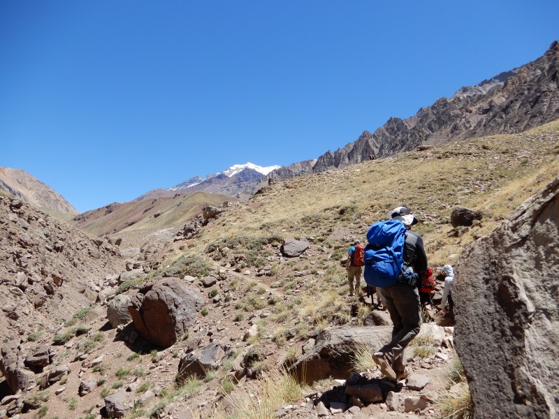 After about 3 hrs (including breaks), we arrived at Confluencia. Our group stuck pretty much to a schedule of about 1hr of walking followed by a strict 15 minute break. During that 15 minutes, we were to layer up, eat, drink, apply sunscreen and lip balm, bathroom, layer down, and get back to walking. The idea was not to let breaks rule, as it would be easier and easier to rest longer and longer higher in the mountain. I think that was a good strategy; the only longer break I can remember was our last break at the cave before the summit. 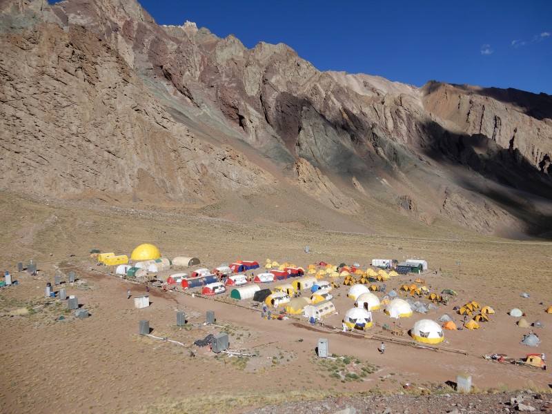 The shot above shows Confluencia from a small hill outside of camp. You can see all the restrooms in the lower left, the various guide services cook and dining tents, the individual tents and the ranger/doctor area in the upper right. There was running water for the restrooms (flush toilets) but overnight they piping could freeze up. The dining tents (at least ours) were big enough to seat 10-12 comfortably. The tent sites were mostly level and overall it was a nice camp. With our local guide service (Aconcagua Mountain Guides), we had juice and water on the table, tea packets, and quite a bit of food for breakfast and dinner. Eggs and toast dominated the breakfast menu; soup some meat, and some starch was dinner. Day 2: Confluencia (10,286') to Plaza Francia (13,123') 9.7 miles; 4:30 moving time; 2,500' ascent 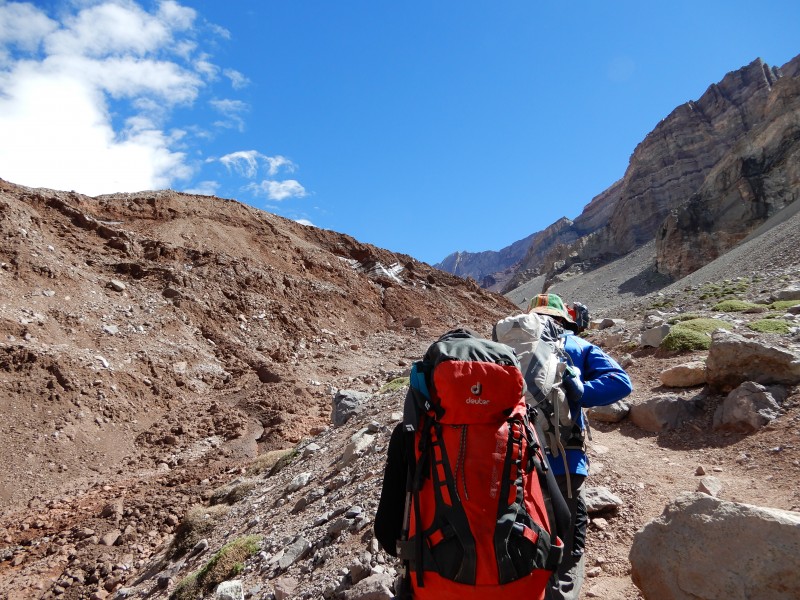 The next day, we did the acclimatization hike to Plaza Francia. It was a relatively mellow hike, mostly alongside a glacier, to an overlook of the South Face of Aconcagua. This was maybe the first time the scale of the mountain hit home; looking at a 7,000' face of the mountain. On the hike back, we noticed these divot type things in the ground. Our guides said they were from rockfall bouncing across the valley floor. 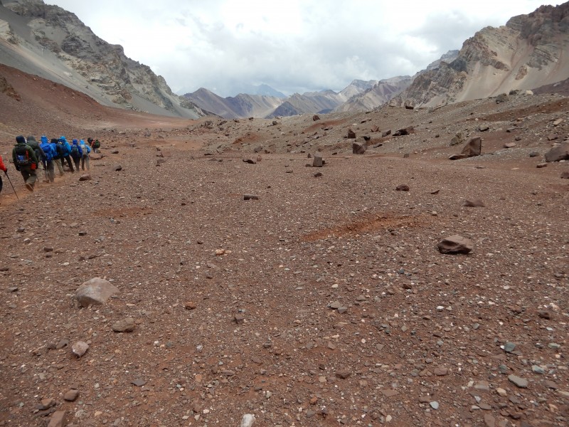 Right before returning to camp, we passed a large mule train (on the main trail to Plaza de Mulas). A good example of how dusty it can get on the trail when these guys are passing. 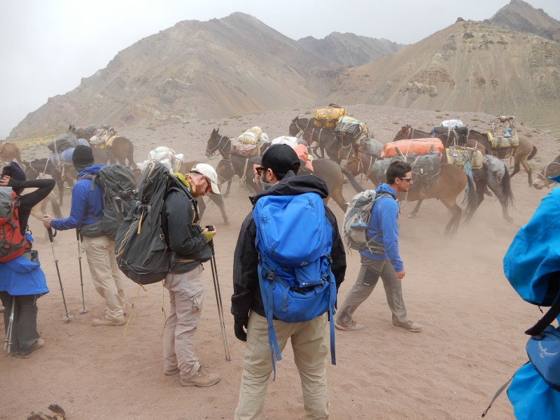 I think we visited the doctor today to get clearance to proceed to Plaza de Mulas. Our group passed. They check blood oxygen levels, blood pressure, pulse, and would listen to your lungs if concerned about anything. Asked how we were sleeping, how we felt, and if we were taking any medications. Day 3: Confluencia (10,286') to Plaza de Mulas (13,976') 12.8 miles; 6:30 moving time, 3,500' ascent I had read reports that this move day was second in effort to summit day. It was certainly long; the elevation gain comes mostly toward the end, but wasn't too bad in my estimation. After a few ups and downs out of camp, the trail settles into the large river valley for probably 8-10 miles. Each section of valley may be 2-3 miles before rounding a corner; again with the scale. You can see people in the distance as dots and at times could feel like you were never making any progress. 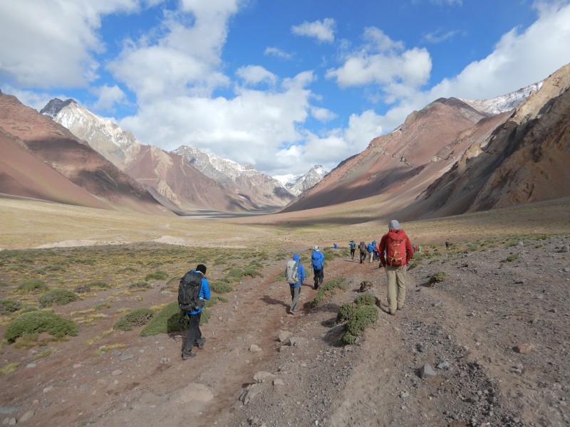 The river in this flat valley changes course quite a bit. On the way up, we avoided all river crossings but at times were traversing our way around the river on sloped, loose terrain. The river washed out some of this on the way down, and we had some crossings to contend with. 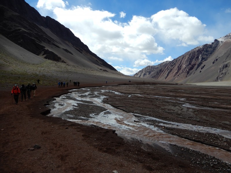 As mentioned, most of the elevation gain is closer to Plaza de Mulas. Here is probably the biggest push of the day, maybe gaining 800-1000' up this slope. Of course the trail was uphill before and after this, but this is a very distinct up on the way to base camp. This area is also where we saw the most mule bones. You can see people a bit above center just cresting this rise. 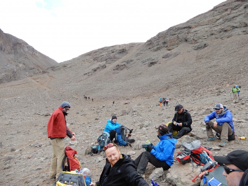 Plaza de Mulas is tucked right up against the slope of Aconcagua. Each day at camp, we could look up and see the weather at/near the summit. Most days at basecamp we saw this, and it was hard not to try to predict the weather still 7-10 days away. Some days early on it was quite windy on the summit, but calm at base camp. 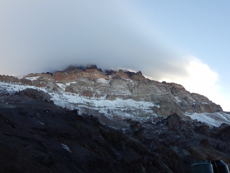 Day 4: Rest day at Plaza de Mulas This may have been one of our true rest days on the trip, with no gear sorting, crampon practice, etc. The guides suggested we walk around some; there is a nice ridge to the north of camp where you can look back and see the sprawl. It is rumored that PdM is second only to Everest in size of base camps. There are bars, the art gallery, showers, dining tents, etc. that make it a pretty big place. Probably a 20 minute walk from the low point in camp to the high point. Our camp was at the high end, foreground in the photo with the yellow and white tents. Pretty much the same set up as Confluencia, but pit toilets instead of flush. You can also note in the photo the trails to the left of camp up/down the mountain. The trails near the stream are the down, the up are a bit more in the background. Still pretty level tenting sites, less so if the camp was crowded. 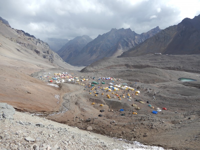 Day 5: Plaza de Mulas (13,976') to Mt. Bonete (16,732') 6.9 miles; 5 hrs moving time; 2,300' ascent) Our second acclimatization hike but I guess also would be the consolation peak for whatever reason. Mt. Bonete is across the valley from Aconcagua; we had to cross the river (over a broken bridge), walk by the old (and shut down) hotel, the ranger station, then up the basin to the east ridge of the peak finishing with a traverse to the north ridge and last few steps to the summit. We kept a slow steady pace up, the trail was pretty well switchbacked to make the day pretty enjoyable. Below is a few folks coming up to the east ridge, just before the start of the traverse to the north ridge. At the end of the traverse, the route was a bit steeper and rockier (still Class 2 probably). 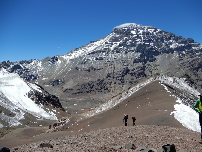 In this photo, you can see the (foreshortened) view of Aconcagua and can see the general path up the hill. Just left of center in the photo you can see a thin, near vertical line of snow. Basecamp is straight below that and Camp Canada is just at the top of the vertical snow line just to the left behind the dark rocks. The route up moves up and to the right through the cliff bands, then moves back left and ascends very near the right side of the "V" snow formation. From Canada, the route goes up and left to the small shoulder to the right of the dark rocks just below the ridge line. As would be typical of the entire upper mountain of Aconcagua, our descent from Mt. Bonete would be nearly straight down, plunge stepping through the scree. A gear note here, I used trail runners for the hike to base camp, but the scree above base camp was too deep for low top shoes. Those in our group that had high top hikers were able to wear those; I (and others) had to wear our mountain boots. Pros and cons of each choice; we got more practice in our boots down low, but the risk of blisters certainly went up. Day 6: Carry from Plaza de Mulas (13,976') to Camp Canada (16,108') 3.3 miles; 3:30 moving time; 2,250 ascent. Although we had porter support, today we would carry group gear from PdM to Canada. This was probably as much an acclimatization hike as anything, but we all carried approximately 10-15lbs of group food and gear up the hill. With personal gear (including food/water), my pack weight was about 35lbs. The trail up to Canada was a bit steep out of camp as we worked through the lower cliff bands, then the switchbacks got larger and we worked climbers' left across the face. After a quick break at Conway Rocks, we finished our climb to Canada. Cached gear and then headed straight down back to PdM. Plunge steps again so mountain boots or high tops. In this photo, taken from Canada, you can look across the valley at Bonete left of center and just see basecamp in the bottom of the valley. 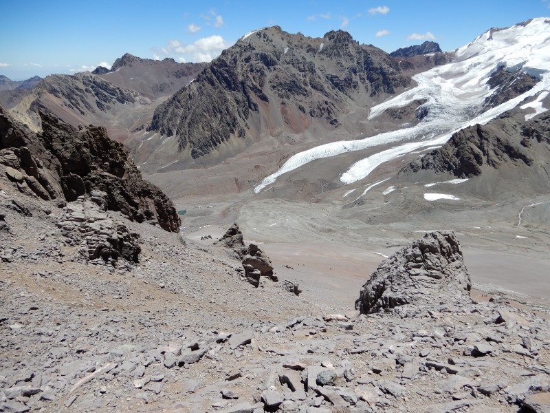 Day 7: Rest day at Plaza de Mulas (13,976') Even though a rest day, we were quite busy here. We had to sort our gear into what was going up the mountain and what was staying at basecamp. General advice was to plan to wear the same clothes (except underwear and socks) for the next 6-7 days. How much toilet paper to carry? How many Advils to pack? Down booties? These were intensely discussed among the group as we sorted out what stayed and what was going up. We also went to the doctor today for our final checkup and clearance for the upper mountain. Day 8: Plaza de Mulas (13,976') to Camp Canada (16,108') 1.9 miles; 2:50 moving time; 2,150' ascent Finally on day 8 of the trip proper, we were leaving base camp and heading up the mountain for good. I felt pretty good today despite covering the same ground as a few days back. Once we got to Canada, we got settled into our tents and had a leisurely afternoon. A note on leisurely afternoons, most days would look like this: Stay in your tent until about 9am when the sun came up. Breakfast, pack camp, and get moving by around 11am. Walk 3-5 hours to get to next camp. Set up tents, unpack gear. Try to finish dinner before sun goes down around 8-9pm. Spend next 12 hrs in the sleeping bag. Once the sun went down, it got cold fast. So that meant every afternoon is a slow race to get settled, get hydrated, and get fed before cold would drive you inside. Camp Canada was very sloped, and the tent sites were uncomfortable. I would say the most unlevel camp of the bunch. Day 9: Camp Canada (16,108') to Nido de Condores (17,244') 1.7 miles; 2:35 moving time; 1,650' ascent We're moving now. You can see from the notes that we averaged about 0.7 miles per hour on this day. I can understand why people quote distances in hours versus miles. However, I think that the miles are important because that is how many steps I will take in my boots. I had walked my mountain boots plenty of 4-5 mile days in training, so these days didn't seem too bad. The slope out of Canada is still pretty steep. In the picture below from Canada, once you get to that ridge line (Cambio de Pendiente) or "change of slope" the trail gets a bit easier most of the rest of the way to Nido. I recall that right before camp you get a bit steeper to pop out over another ridge, but nothing too bad. This was the only day other than summit day that I felt the altitude while walking. We were breathing deeply (not quite pressure breathing) but I still felt a bit dizzy and out of sorts. I started Diamox either this day or the next, but only took for two days (more below). 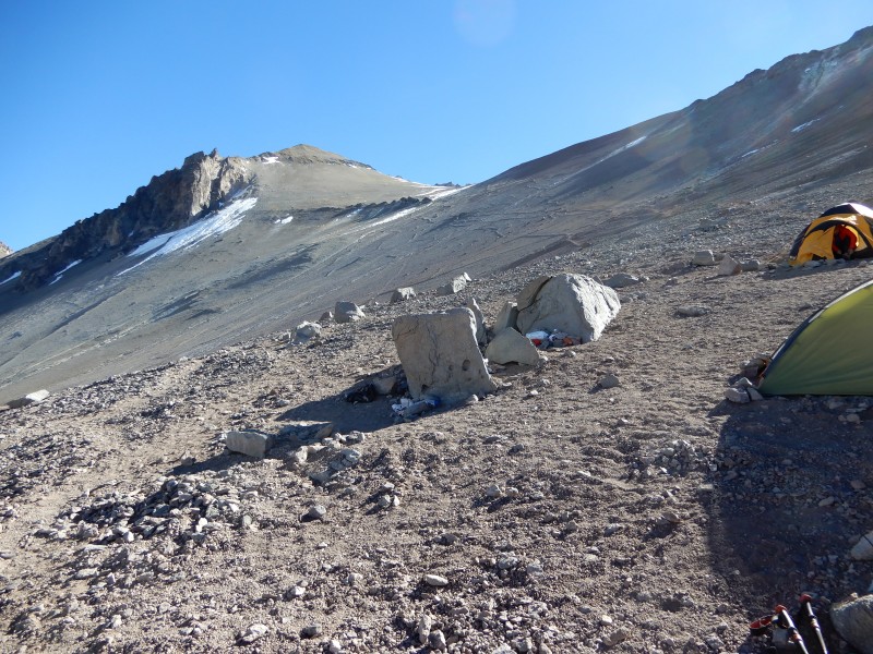 At Nido, same afternoon of setting up camp, unpacking gear, hydrating, and eating. Since Nido would be our likely weather delay hideout, we spent a bit more time on the tents and getting comfortable in them. As we move higher, we became more concerned about bomber tent guying, so we collected more rocks each camp as we moved up, which was tiring as we got higher. Nido is also where our weather pattern changed. For the next few days, we were seeing clear and calm mornings and afternoon / evening snow. The guides really like our situation with the calm winds. However, the snow accelerated our afternoon plans a bit to get done and in the bag to get warm. Not sure that we could see the summit as we rolled into camp due to the snow. Day 10: Rest Day at Nido de Condores (17,244') Another busy rest day. We woke up to clear skies but snow on the ground. The shot below shows the summit. The upper traverse moves across the top of that snow slope from left to right and the Canaletta is the top basin that is partially obscured by rocks. You can somewhat see a path down the left side of the snowfield, that is the direct descent to Nido bypassing Colera. 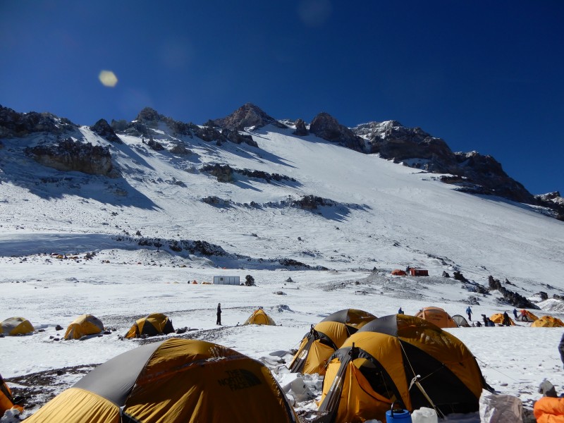 The other shot shows the route out of Nido toward Colera. Traversing left and turning right before the ridge line to ascend that shallow gully. 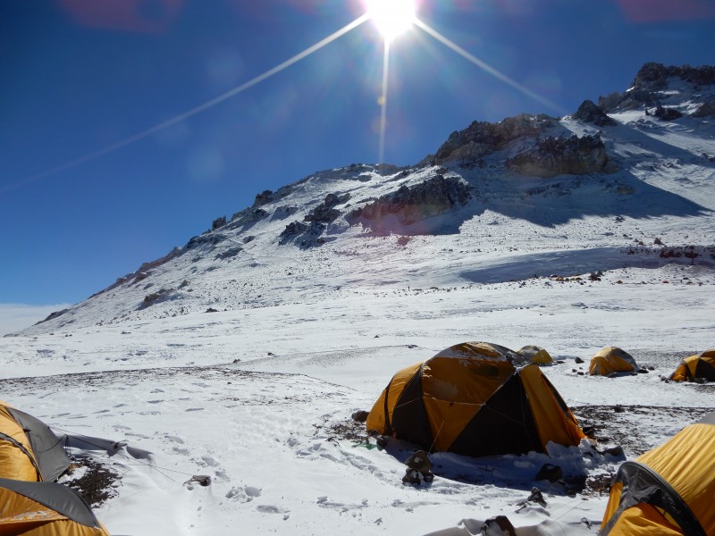 Today we would put our crampons on and practice walking around camp we also practiced self arrest skills. I was walking pretty slowly around camp; certainly feeling the altitude. It was amazing how decent I could feel laying down or sitting on a rock, but feel it the moment I stood up. Day 11: Nido de Condores (17,244') to Camp Colera (19,685') 1.5 miles; 2:35 moving time; 1,470' ascent The weather forecast showed the continued pattern of clear mornings and snow in the afternoon, with relatively low wind. This would change in 3-4 days so we needed to stay on schedule. Our move up to Colera was pretty uneventful. Although there was snow on the trail, we made the move without crampons. There is a spot near Colera where the trail is steep and rocky; cables were installed to grip onto while moving up. If it were dry I don't think it would have been any issue, but in snow and in boots, it was a bit slick and the cable helped. The camp may only be 100 yards or so past this point.  Colera is a pretty small camp. Even at Nido there were some communal tents set up but here were just individual sleeping tents. As we guyed out our tents, a lot of the bigger rocks had severed line still attached. Rumors of tents getting ripped out and blown away seemed pretty well founded. Here we also set up tents on the snow for the first time. Only about 6 inches so not much need to compact ahead of time, but made for colder sleeping. 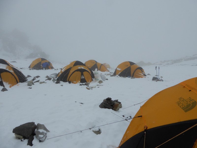 Other than Denali grads, this was the highest we all had been in general; we would be staying at or above this altitude for the next 1.5 days. Certainly could feel the altitude here, but I felt pretty acclimatized. Note that our guides suggested that bodies really aren't producing significantly more red blood cells yet; that we were mostly getting our brains and body used to the altitude, so it didn't feel so shocking. Not sure if that is true, but seemed to be a good explanation. Day 12: Camp Colera (19,685) to Summit (22,841') and return: 6.3 miles; 11:35 moving time; 3,250' ascent After 11 days moving up the mountain, summit day was here. Up by about 3:30 am, we were moving out of camp by about 4:30am. We moved up a moderate slope toward Indepencia. Although the sun was behind the mountain, we could see the world lighten up. Always amazing to have big clouds below. 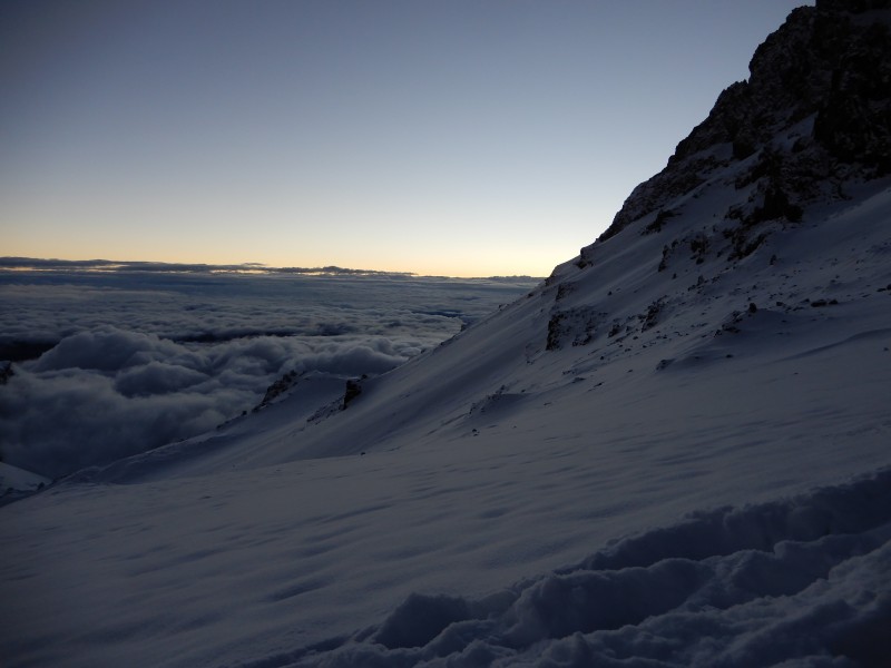  Not much at Indepencia, just the broken down hut. We took our break here, not much distance to go before rounding the corner for the Gran Acarreo. Again, we got pretty lucky on the weather. I don't recall much, if any, wind on the traverse. It was a bit colder as we moved back into the shade, but still very good conditions. We did stop a bit past El Dedo to put on our crampons. About six hours into our day, we got to the Cueva our last break before the summit push. In this photo you can look back across part of the traverse and see El Dedo way down below and in the distance (looks like a person in the photo). Note that if you turned left at El Dedo, you would be on the direct route back to Nido. 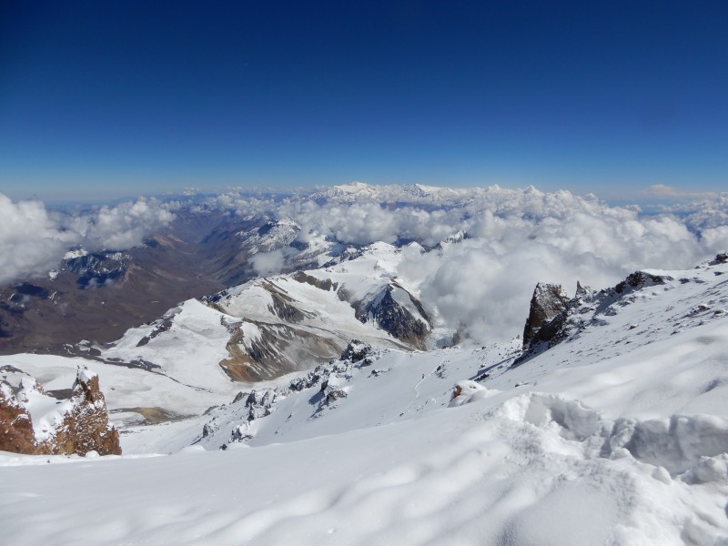 The Cueva is just an overhang in the rocks. Would probably get you out of the wind, but since we had no wind we set out a bit in the sun. Here is a shot looking up from La Cueva and in the top center shows the top part of the Canaleta. 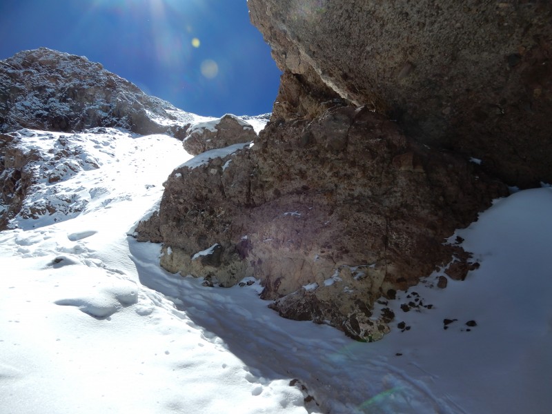 The next photo shows a lot. We are just leaving La Cueva. You can see how much shadow there is; looks pretty protected. You can also see clouds building in the background; these are headed our way. Also note our clothing. Again, very warm and calm conditions. I am about 4th back in my yellow R1 with only a long sleeve baselayer below it. I have a baselayer bottom on but I think only my softshell pants. 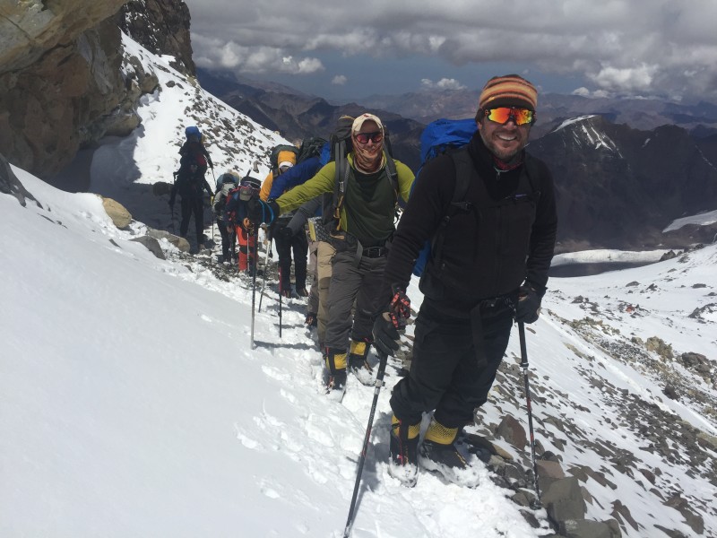 Pretty steep up the Canaleta. The snow and the crampons helped quite a bit. I don't recall slipping back that much. 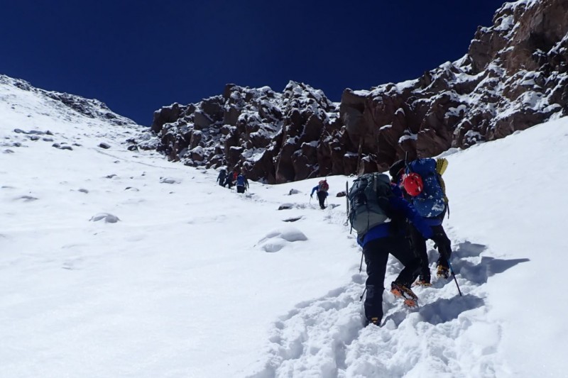 It took us approximately 2 hrs to climb the last 800' up the Canaleta. By the time we reached the summit, I was taking 3 full breaths, then on the 4th taking a step. Given the slow pace, I felt really good and strong (considering). However, by the time we reached the summit, it was snowing on us. We couldn't see anything up top, the snow was melting to us, so we only spent about 15-20 minutes on the summit. 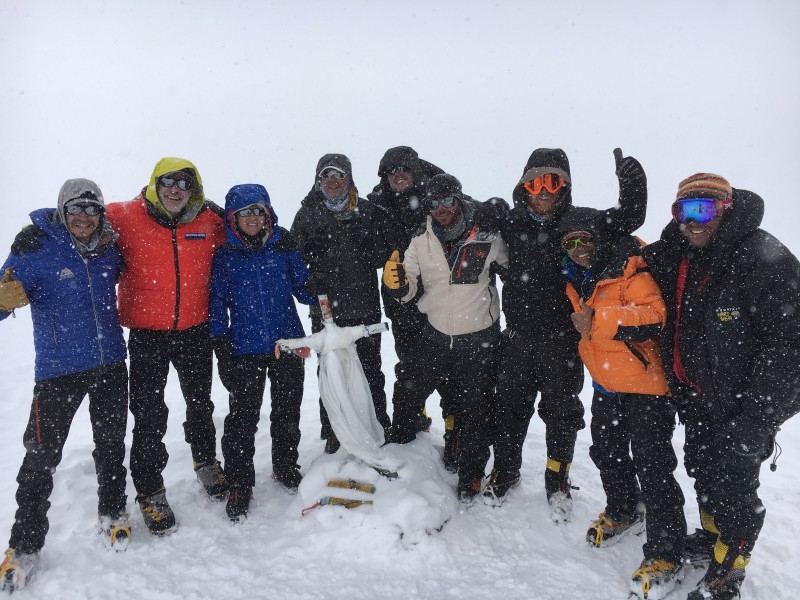 It took us about 8 hours to the top and about 4 hours to get back to camp, for about a 12-13 hour round trip. Our route down was interesting as we were headed straight down (after Indepencia) and shortcutting the trail. We had to wait until the weather broke to spot camp, adjust direction, and repeat. Once we got back to camp, we hydrated and ate as best we could, and tried to sleep. Day 13: Camp Colera (19,685') to Plaza de Mulas (13,976') 3.2 miles; 1:55 moving time; 5,250' descent 4 days up (including rest day at Nido) and about 3-4 hours down. We got up to another clear morning and were all happy about our summit. What we couldn't see the day before or on summit day in the dark, the route up toward Indepencia follows the snowfield above the guy in the blue jacket.  Moving down was fast. I was a bit uncomfortable with the 6" or so of new snow on top of loose rocks, wearing my crampons. That said, we were moving quickly, passed Nido, and took off the crampons around the Cambio. From there, the scree was more predictable and we made good time back to Plaza de Mulas. Back at camp, there was plenty of wine purchased ($25-35/bottle), beer purchased ($5-10/bottle or can) but surprisingly no showers. We all elected not to put tents up, so some purchased a dormitory ($30), some slept in our dining tent, and some slept in the kitchen (warmer). Day 14: Plaza de Mulas (13,976') to Penitentes (9,350') 16 miles, 6 hrs moving time; 5,000' descent. I'm not sure I trust the moving time here. The talk around PdM on the way down from Colera was the helicopter option to get back to the park entrance. It worked out to approximately $800 per person for the helicopter ride and another $50 or so for a second shuttle back to Mendoza. For various reasons, 6/9 of our group opted for the helicopter. For me and the other two, we had a very long, somewhat enjoyable, walk out the 16 miles or so. A good portion of the trail was easy, mostly downhill, but enough rough or uphill to remind me of what I was doing and what I had done. As others have said, the walk was immensely more enjoyable after a successful summit. Had I not summited, I would have opted for the helicopter. As noted, one surprise was how much the trail shifted over the two weeks. The stream/river changed course a bit, what seems like the trail going up has better options going down, but there were quite a few places where our route was different. Jumped the stream in a few places, but no river wading. We got back to the park entrance before our mules. So we purchased some beer and potato chips and relaxed at the guide service waiting on the gear. That was a very good celebration! Once the gear arrived, we headed back to Mendoza, arriving around 10-11pm. Not surprisingly, I felt sorry for the shower at the hotel. It seemed that for the first few minutes, it was mud, not water leaving my feet. Group Health I was surprised at how much the mountain debilitated our group, despite what our Argentine guide says were pretty much perfect conditions (absent the snow). Our group supports the notion that one should not take this mountain lightly. Somewhere in town or on the mountain, we all got sick with some sort of head cold. The conditions at Confluencia and Plaza de Mulas were perfect for spreading those germs around. Most of us were over it by our move to Canada on day 8. Our group started as 10. One of us began to feel the altitude effects on day 3. He was sick with the cold and probably some AMS by the time we got to base camp. We had our rest day, he rested during our climb to Bonete but informed us he was dropping out when we got back to camp. One of our guides was also quite sick, and I think ended up taking some Dex at base camp to help his recovery. Out of our group of 13, probably 5-6 were noticeably set back with the cold. I started taking Diamox on day 9 (after arriving at Nido). This was after feeling poorly on the walk in that day, but I was also having trouble sleeping. It seemed that just as I was drifting off to sleep, I would stop or slow down breathing and gasp myself back awake. I took 125mg for two days then got the tingly fingers and toes. I didn't enjoy that feeling, so stopped taking after the two days. Around this time, probably 4-5 of the clients were taking Diamox (including me in that count, but I think I was the only one to quit). One of the signs of AMS heading to HACE is confusion. At basecamp, we saw a climber come down that was somewhat delirious. One of our group showed similar behavior high on the mountain. Some simple things like not drinking water and not applying sunscreen. I won't get into other specifics, but it was something we should have payed closer attention to. One of the results of their behavior was that the morning after summit day they could not open their eyes or mouth (dehydration I think). This person ended up in the hospital in Mendoza. One person in our group had frostbite on one finger. Although warm and calm, the consensus was wearing too thin of gloves and gripping poles too tightly compressing the insulation in a finger. 3-4 of us developed fluid in our lungs summit day or the night after; I was one of them. I went to bed fine, but several hours later woke up coughing fluid. Since I was not short of breath (no one was), and it was the middle of the night, and we were heading down the next morning, there really was nothing to do and the guides (and one of our team who was a doctor) weren't too concerned. Note, it took me about a week and a half to get rid of the cough. For the rest of the group (including me), sunburn, lip burn to the point of blisters, sunburn on the inside of our mouths, blisters, and the cough were par for the course. For the first few items, we all put on sunscreen almost every hour, we wore hats and buffs, but still suffered to one degree or another. We also all had misc. cuts and nicks on our fingers. In such a cold, dry place, it was easy to split the skin just by picking up a rock or setting up a tent. I think that 6/10 of mine (both thumbs, index, and middle) were painful by the end of the trip. One of the upsides I guess is that I don't think many in our group had sore muscles. Nobody was hobbling too much on the few days back in Mendoza. Gear Thoughts This is a tough one to reconcile since we had very mild conditions on the upper mountain. For example, I may have started summit day with my expedition parka but if so only wore it for the first hour. So therefore, I am not in a position to evaluate that piece of gear. As usual, my best piece of gear was my R1 hoody. Great insulating layer and even better for wearing in the sleeping bag. The length of travel of that zipper can regulate temperature very well. Most of the upper mountain I wore the R1 with either a short sleeve or long sleeve base layer, and my hardshell (rain jacket). Conversely, down low I really enjoyed my OR Echo Hoody. One of the lightest long sleeve shirts out there, with hood and thumb holes. Kept my neck, ears, and my wrists out of the sun without feeling warm at all. The La Sportiva G2SM were pretty good. I think they were a bit narrow for my feet, but warm, light, and easy to wear. I got a blister on the way down from the summit, but blame most of that on the snow, rocks, and crampons. It was challenging for me to learn to walk from the heel (vs. trying to push off with my toes). Some in the group with the new Scarpa Phantoms had trouble with the zippers due to all the dust/debris. Not so much on the G2SM, but bringing some sort of lubricant may be handy. I wore toe socks under my boot socks. Good Choice for blisters but bad choice for the same reason that mittens are better than gloves when it was cold. I felt it on summit day; fortunately we warmed up before my feet got too cold. I would leave toe socks at home, or at least leave them at base camp. I did not care too much for my sleeping bag, the North Face Inferno -20. It was very light and warm for the temp rating, but as a warm sleeper and a side sleeper I didn't care for the center zip. Very tough to regulate while I was flopping around so much. Oddly, I had tried it out before the trip in similar temps and slept very well. Also, the regular length seemed to compress on my head and feet. I'm 5'10 and the bag as supposed to be good for 6'0. That would cause me some cold feet higher on the mountain. If someone is a back sleeper, the bag would be great, just size up if you are around 5'10. Buffs were used as dust masks primarily. Given that, for me they needed to be in that âin between" stretchiness and I brought two. My new one was pretty tight and somewhat uncomfortable; my old one was too loose to hold a tight seal on my mouth/nose. Get the lightest ones you can, and break them in a bit. My pee bottle was too small. I had 1L and needed 1.5L. Pretty consistent in our group that we were full by 3-4 am. I had an Anker 20,000 mAh battery (two actually). I used it to charge my Fitbit, my phone, and my camera. I swapped out for a new one to move up the mountain from basecamp. Both were about 75% full when I got back. I let my tent mate charge some of his stuff as well. I usually put them in my bag for 30 minutes or so before charging anything, but these were awesome. I could have gotten by with one, and a spare camera battery. Headphones and Iphone content. Given the sundown and sunup times and the 12 hours spent nightly in the tent, get some podcasts, music, etc. Most of the rest of the Alpine Ascents gear list was pretty spot on. Not our puchased gear, but we used the North Face VE 25 on the mountain. A 3 person tent shared by two people. There was plenty of room inside, but in my opinion the vestibules were a bit small to hold backpacks and mountain boots. They were overall pretty easy to set up, take down, and live in. Guide Thoughts I have used AAI twice now and have been happy with them. They contracted with Aconcagua Mountain Guides and I was very happy with them as well. AMG provides the services at base camps; we also had one of their local guides. Different a bit from Kili, but it seemed that most of the main guides (AMG, Inka, etc.) on the mountain had similar levels of service. The meal tents, the bathrooms, etc. were all pretty similar in nature. I suspect that the menus among the various service providers was similar too. On the mountain, we learned breathing techniques, the rest step, the duck step, the French step. We practiced walking in crampons, self-arresting, and walking in mountain boots in general. I suspect we got a bit more education utilizing AAI, but I don't know that for sure. Our AAI guides had been on Denali quite a bit. It was interesting to hear them talk about their experiences in Alaska. One of the two had been on Aconcagua before, but on the Vacas Valley route. We were also the second group ever (first was a day ahead of us) for their Normal Route offering, so (1) we had to figure out a few things on the way up (mostly porter use) and (2) we had to rely on our local guide for much of the distance, route, break locations, campsites, etc. Our local AMG guide (Mariano Vazquez) was a rock star. Everyone knew him on the mountain, and quite a few of the restaurants and shop keepers in Mendoza knew him. I think we got some preferential treatment on the mountain due to him. For example, we were able to hire half porters. I suspect that is somewhat common, but is not very well advertised. Our porters would also set up tents for us if they arrived in camp ahead of us. Very nice. Mariano himself was very knowledgeable, and it was fun learning some new Spanish words from him. Overall, as expected, a guide service makes the trip more seamless and smooth. In exchange for that comfort, you give up some flexibility. We were on a trip schedule, a daily schedule, a break schedule, and a walking pace dictated to our entire group. It was an acceptable trade for me. Overall Thoughts I loved being on this trip on this mountain. We had a very strong group (clients and guides) that got along very well. From the hotel in Mendoza back to the hotel in Mendoza, there was a really cool vibe with the flow of people to and from the mountain. Experiencing all of the landmarks, the camps, and the summit was pretty surreal. At least for me, spending 5 years or so reading trip reports, then seeing and experiencing it all in person kept me in a state of wonder most of the trip. I felt strong, did well with acclimatization, and overall felt good over the majority of the trip. I do recognize how lucky we got with weather. Most of our two weeks on the mountain were warm and calm, even if a bit snowy. I certainly see how the mountain can be underestimated. Each section of the trail wasn't too difficult, and I would go so far as to say it is class 2 maybe class 2+. That isn't what makes the mountain tough. It is the accumulation of days, miles, cold, and elevation against unpredictable weather that adds up to make the mountain tough. As mentioned, all in our group suffered to some extent. Being that high for that long is no joke if Kili is one's only reference point. Also, as mild as it was, we all got cold on the mountain. Certainly, the challenge adds to the enjoyment. Thanks for reading. Thumbnails for uploaded photos (click to open slideshow):  Overall route on upper mountain")
 Getting gear ready for the mules")
 A walk in the park")
 Trail to Confluencia")
 Camp Confluencia")
 Beside the glacier on the way to Plaza Francia")
 Rockfall evidence")
 Traffic jam")
 Big valley on the way to Plaza de Mulas")
 The river and the trail")
 A steep section below Plaza de Mulas")
 Summit view from Plaza de Mulas")
 Base Camp")
 Aconcagua from Bonete")
 Bonete from Aconcagua (Camp Canada)")
 Trail from Canada toward Nido")
 Part of route from Nido to Colera")
 Upper mountain, showing the Gran Acarreo")
 Cabled section below Colera")
 Camp Colera")
 Sunrise on summit day")
 Above Indepencia")
 Looking back across the Gran Acarreo")
 La Cueva")
 Summit push")
")
 Route up from Colera")
 Summit in the snow")
")
|
| Comments or Questions | ||||||||||||||||||||||||||||||
|---|---|---|---|---|---|---|---|---|---|---|---|---|---|---|---|---|---|---|---|---|---|---|---|---|---|---|---|---|---|---|
|
Caution: The information contained in this report may not be accurate and should not be the only resource used in preparation for your climb. Failure to have the necessary experience, physical conditioning, supplies or equipment can result in injury or death. 14ers.com and the author(s) of this report provide no warranties, either express or implied, that the information provided is accurate or reliable. By using the information provided, you agree to indemnify and hold harmless 14ers.com and the report author(s) with respect to any claims and demands against them, including any attorney fees and expenses. Please read the 14ers.com Safety and Disclaimer pages for more information.
Please respect private property: 14ers.com supports the rights of private landowners to determine how and by whom their land will be used. In Colorado, it is your responsibility to determine if land is private and to obtain the appropriate permission before entering the property.