| Report Type | Full |
| Peak(s) |
El Diente Peak - 14,175 feet "West Wilson" - 14,101 feet Mt. Wilson - 14,256 feet Wilson Peak - 14,021 feet |
| Date Posted | 08/22/2020 |
| Date Climbed | 08/15/2020 |
| Author | natebennett |
| The Choss Boys Ride Again - Wilson Weekend |
|---|
|
8/14/20: Woods approach to camp far above Navajo Lake. Moving time: 2hr 45min (about 2hr to Navajo Lake from TH). 8/15/20: Up El Diente's North Buttress route, across the traverse to Mt. Wilson, tried to go down Mt. Wilson's North Slopes route but got horribly lost, somehow made it back down to the basin, up and down Wilson Peak's Southwest Ridge route and then back to camp. Moving time: 5hr 30min, elapsed time: 11hr 30min! We must have taken lots of breaks or something :) 8/16/20: Back down Woods approach to the car! Moving time: ~2hr? Strava broke on this one. The Wilson group has long been on my list, especially since I've been eyeing the traverse for a while. After a few foiled plans over the past couple of years, the stars finally aligned! My friend and climbing partner Paris was interested in tackling the peaks too, so we found a weekend that not only worked for both of us, but rewarded us with one of the best weather forecasts I've ever seen for a 14ers adventure! Clear skies, mild temperatures, and an extremely low chance of rain — for the entire weekend! Wow, what a time to be alive. 2020 is really trying to make up for the rest of this crazy year. Anyway, on the morning of Friday, August 14th I loaded up the car and drove to pick Paris up in Boulder. Paris had roped our friend Ben into the weekend at the last minute, so we threw him in the car too and were on our way. After about 7 hours in the car, one stop at Arby’s, and far too many curly fries, we pulled up to the Woods trailhead and set off on the trail by 6:30pm. Woods approach 
The hike in was pretty uneventful and straightforward, with an easy-to-follow trail that switchbacked up through the forest. We reached treeline just as the sun was setting, glowing red through the wildfire smoke to the west. Thankfully, the air we were hiking through was clear and fresh (and stayed that way throughout the entire weekend!). Hiking around the corner before dropping into Navajo Basin, the prominent views of El Diente were a welcome reward for our tired legs! 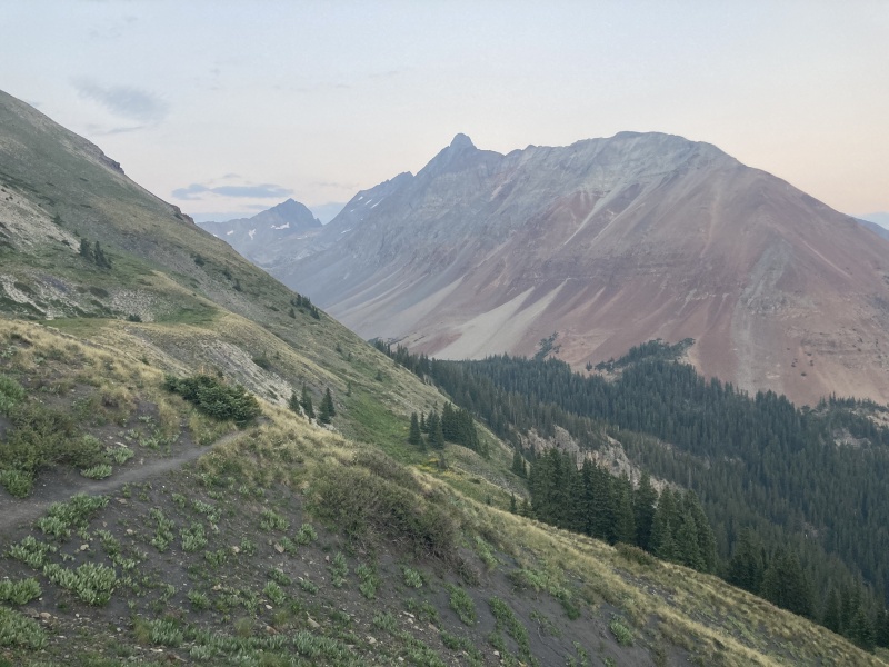
We dropped down the 400’ into the basin and reached Navajo Lake by about 8:30pm, just as the light was almost gone, and we decided to keep hiking up through the dark to find a camping spot higher up in the basin. I wasn’t sure if we would have to hike back down to Navajo Lake for water, but it turns out there was plenty of water in the stream that flows down from the upper basin. Around 9:30pm or so, we left the trail around 12,100’ and found a nice grassy spot to camp beneath El Diente, pretty close to where the standard North Slopes route starts. Paris and Ben had some sandwiches and burritos they had brought with them for dinner, but my dinner was a bit more involved, so I was still finishing boiling eggs and chopping green onions for my ramen as they got settled in their sleeping bags and drifted off to sleep. I tried not to blind them with my headlamp while I set up my tent, and finally hopped in bed myself beneath a sky full of stars. The next morning, my alarm went off around 5:30am, but I decided to snooze until 6am because it wasn’t quite light yet and we were so close to the bottom of the route! Considering that the rest of my 14ers season has consisted of solo sunrise pushes where I started at 2-3am, waking up at 6 made for one of the most luxuriously relaxed mornings I’d had for a 14er in a while. Paris and Ben eventually rolled out of their sleeping bags, and we set out across the rocky meadow around 6:30am. 
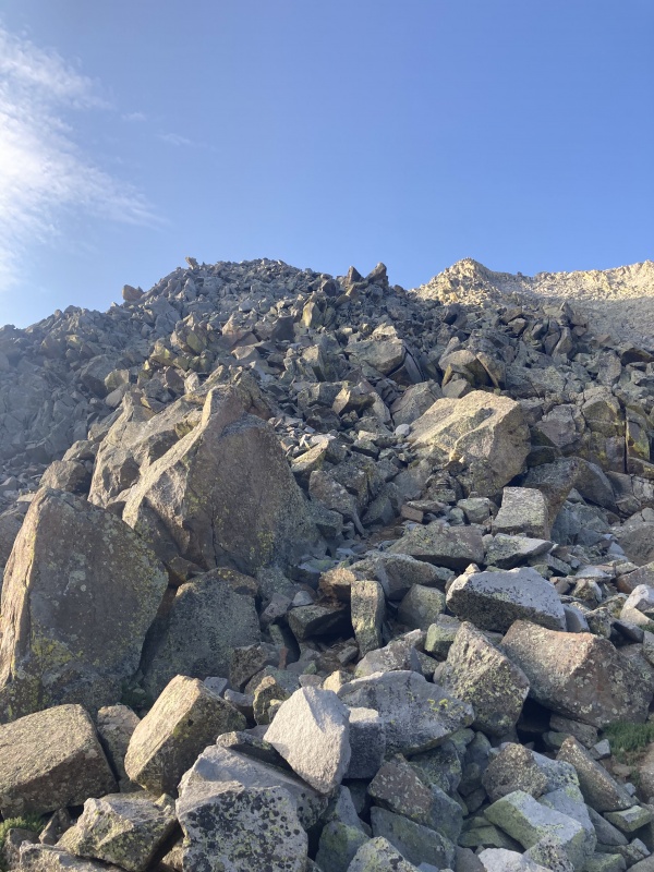
El Diente, via North Buttress route Since our camp was right by the beginning of El Diente’s North Slopes route, we actually had to go back slightly in the direction of Navajo Lake to reach the bottom of the boulder field that marked the bottom of the North Buttress, filtering some water from the stream on the way. We rock hopped up the boulders, finding a few cairns that helped confirm we were on the right track. 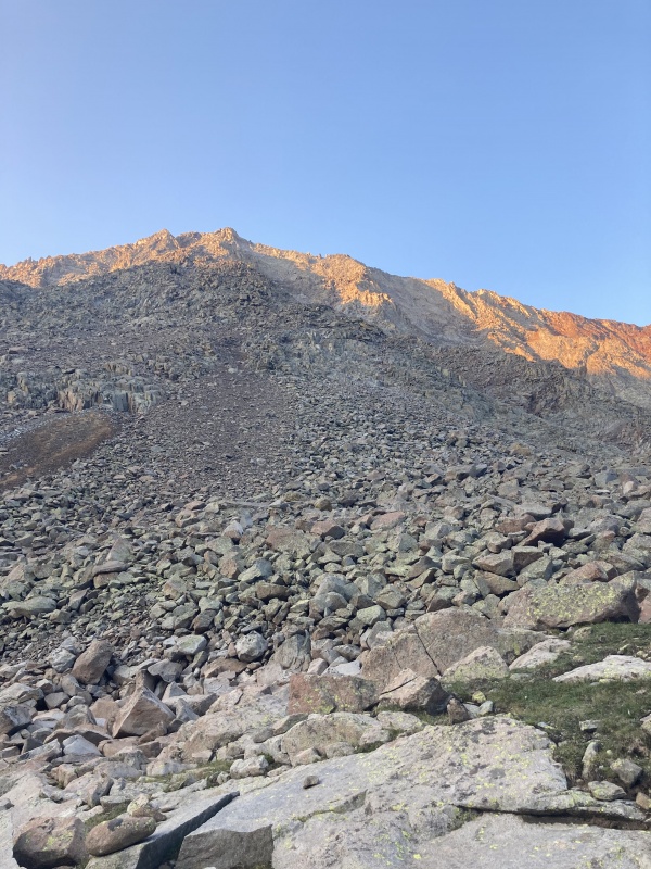
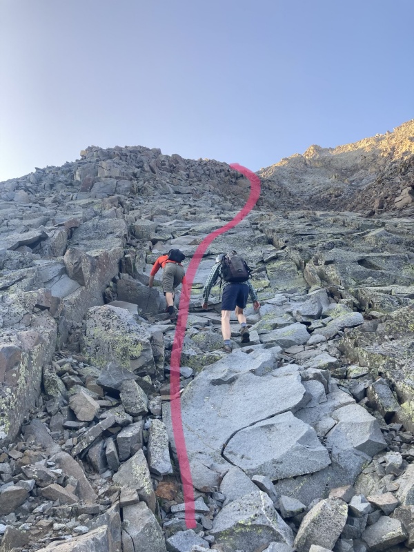
At this point, I think we actually went too far west; we ended up sort of behind the gray slabs and in a gully instead of climbing straight toward the bottom of the slabs. We decided to just climb straight up to the slabs from where we were in the gully, which was a fun bit of class 4ish climbing (pink dotted line in picture is where we went), but it probably would have been less steep and closer to class 3 if we had clambered up to the slabs sooner (yellow line). Looking back at the “Photo #1” overview of the route in the description, it looks like you could take a more direct route to the base of the slabs too. Like much of the North Buttress route, this is probably more of a choose-your-own-adventure situation, and there are multiple options. Don’t worry too much about finding the exact right entry point based on the beta! 
Once on top of the slabs, the rock quality is pretty solid, making it easy to cruise up them. It worked well to stay to the right and just follow the slabs up until you hit the “obvious boulder” that marks your exit point from the slabs, where you cut left and scramble up to the ridge proper for the first time. 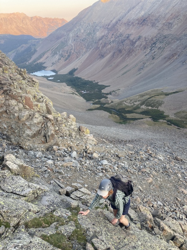
We reached the first bench and took a short break to put on sunscreen and much on some snacks. A climber named Melissa caught up to us here, and she would end up joining us for much of the route to El Diente’s summit, the traverse over to Mt. Wilson, and the descent down into the basin! 
After chatting with Melissa a bit, we started heading up “The Jumble.” From here until you get to the third bench (where you can see the V-shaped snowfield), it is mostly choose-your-own-adventure class 2-3 scrambling up the mounds of boulders. Most of the rock is relatively solid, which makes it more fun than you might expect. There are a few cairns in this area, but I don’t think it’s especially important to try and follow them. Choose the best path and go up! 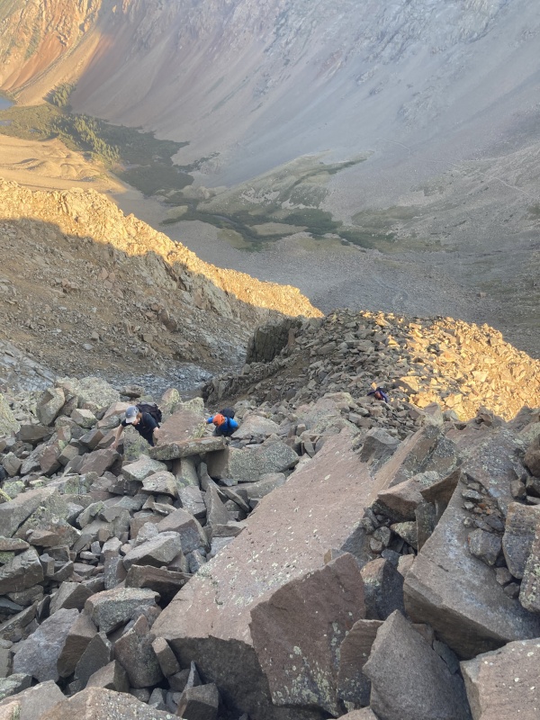
Eventually, we reached the third bench, where you can see the V-shaped snowfield up ahead. The route description is spot-on: from the third bench, climb up to a ledge, move right, do a few class 3 moves up to reach a wider depression, and you’ll see the snowfield directly ahead. 

Here, we moved to the left of the snowfield and straight up to the ridge, where there was some fun slabby rock to climb. When we got above the snowfield, we realized we could have probably stayed lower, climbing up along the left side of the snowfield before joining the ridge, but the way we went was fun (if a little more technical than the trail down lower). 
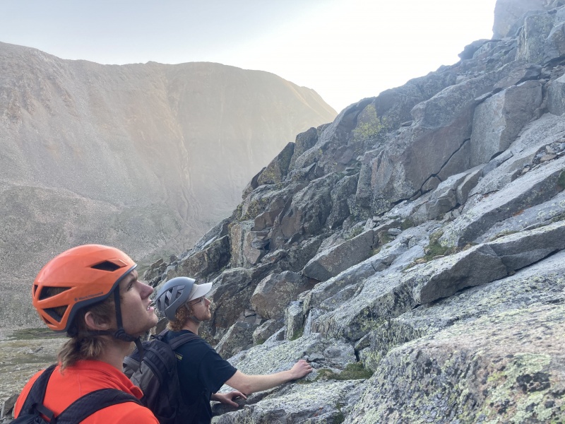
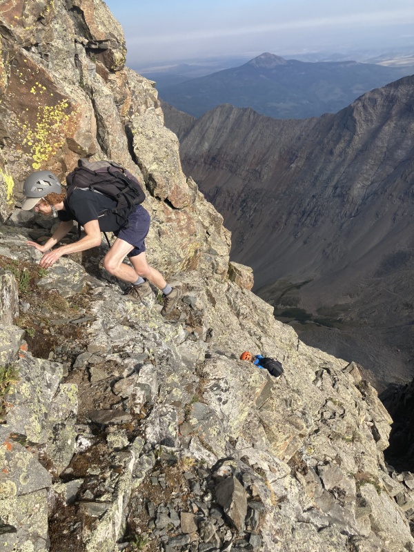
As I remember, the rest of this section up to the saddle (the bottom of the “Summit Pitch”) consisted of fun scrambling, mostly following the ridge. There was one memorable, short spot that has exposure on both sides (see picture), but it is a one-move-wonder and much less sustained than anything on the El Diente-Mt. Wilson traverse (or even the knife-edge on Kelso Ridge). 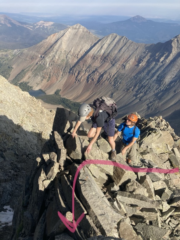
Upon arriving at the saddle, you get a good view of the last bit of the route up to El Diente’s summit. I remembered the route description talking about an alternate, more direct route to the ridge and the summit, so we decided to try that instead of traversing across and up the gray slabs. We climbed up to the base of the gray slabs and climbed up beside them, heading to the right. 
If you go this direction (or at least the way that we went), the exposure is pretty sustained and the climbing stays at consistent class 3/4 levels. 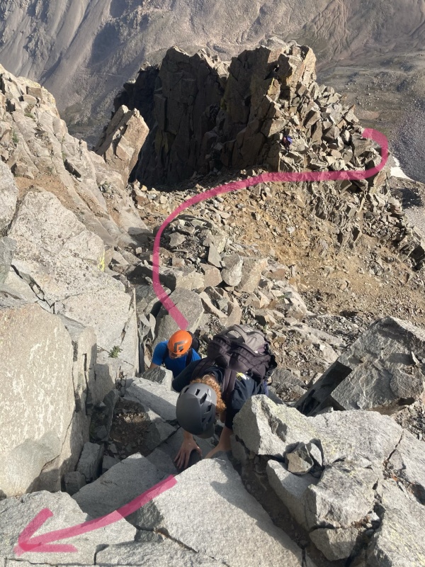

We went slowly, picking the best line up the slope until we arrived at a point where there are two obvious chimneys to choose from. We opted for the left chimney, which provided one last class 3 jaunt before gaining the ridge. 
From here, the summit was just a short walk across the ridge, and we arrived around 8:45am. 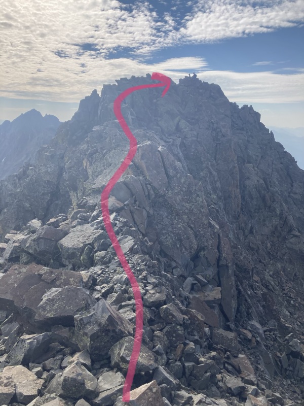
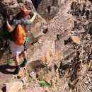
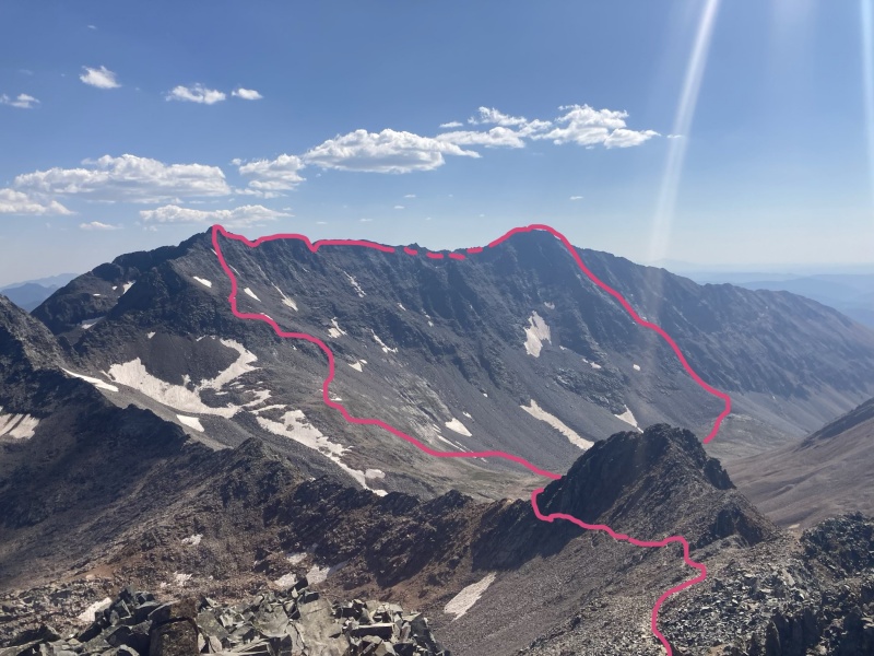
The actual summit of El Diente is pretty small and there were already a few people on it, so we stopped just short of the true summit and had a nice break to eat some snacks and drink water. Melissa, who had opted for the “gray slabs” variation of the summit pitch, had tragically lost the tube for her hydration pack somewhere just before the summit, so she did a bit of searching but to no avail. And Ben had completed his first 14er over class 2! No joke. We were impressed. Paris had attempted the standard North Slopes route on El Diente a few years ago, and estimated it took almost 4 hours to get to the top of the gully because of the loose rock, before turning back due to bad weather coming in. We were all very happy with our decision to take the North Buttress route instead! El Diente -> Mt. Wilson traverse We made sure to get the true El Diente summit before dropping down into the gully to start the traverse. There were quite a few groups coming up towards the summit that we passed on our way down! After dropping down from the summit into a gully and crossing over a small saddle, we followed an obvious trail for a bit before dropping onto the south side of the El Diente-Mt. Wilson ridge. 

There were quite a few cairns that marked the way under the organ pipes after dropping onto the south side of the ridge, but for most of the first third or so of the traverse, the route is generally class 2. We hugged the steeper cliffs to the north, and there are a few ups and downs, but this part of the traverse was pretty straightforward for us. At one point before the gendarmes (I think where the top of the standard El Diente route gully connects with the traverse ridge), we got distracted by cairns and crossed over to the north side of the ridge at a small saddle, before realizing that we were supposed to stay on the south side of the ridge and retracing our steps back to the saddle. 
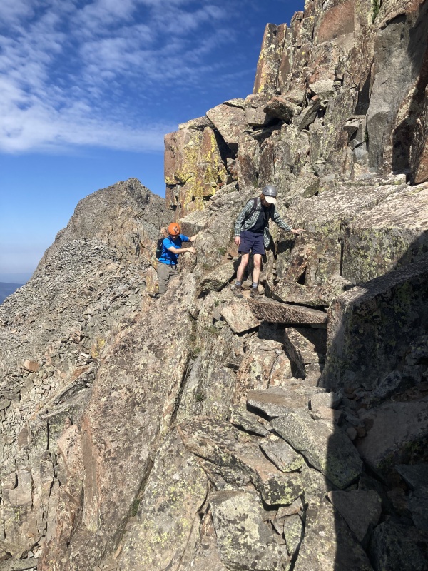
The next memorable part of the traverse came as we approached the towering gendarmes (which in my opinion are better deserving of a cool name like “the organ pipes” than the actual organ pipes). Crossing below these requires class 3 moves across steep, exposed rock. We found that it was pretty well cairned if you take your time and look around, and I personally really enjoyed this section! 

After getting past the gendarmes, we started angling back up toward the ridge. You gain a bit of elevation here, so we took a quick break after reaching the crest of the ridge. 
As mentioned in the route description, the next section was a nice stretch of class 2 hiking that follows the very top of the ridge. 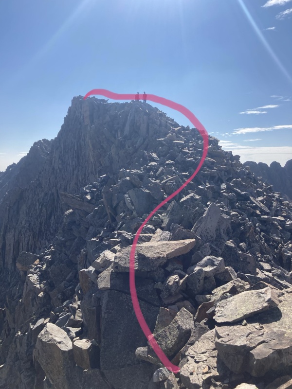
At the end of this stretch is an exposed short exposed section of rock to climb over, before descending down to the saddle where you have a good view of the last tough section of the traverse (“the Narrow Section”). 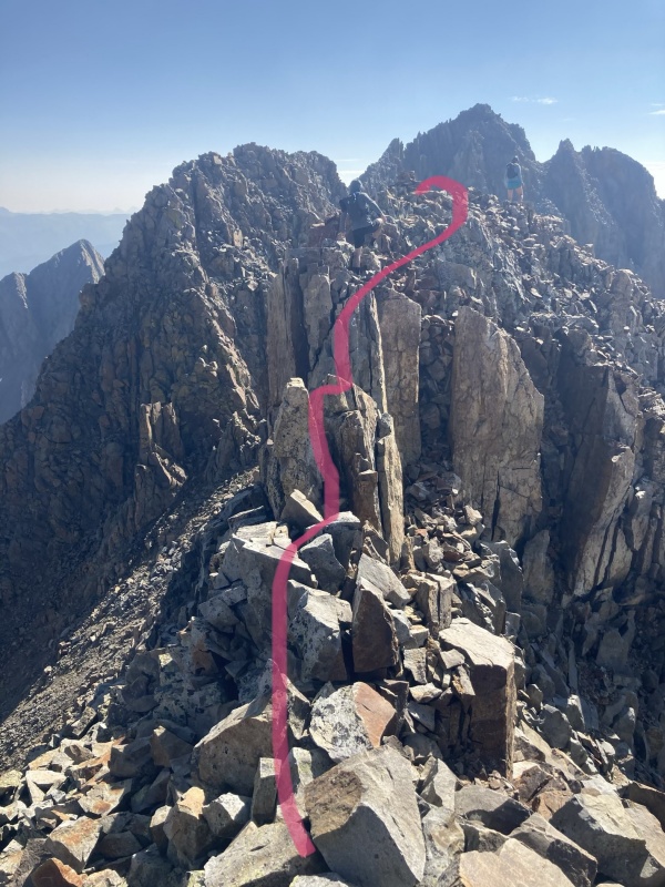
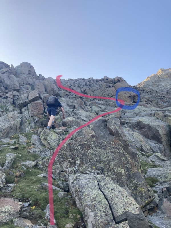
Here, we caught up with a couple of climbers (didn’t catch your names, sorry!) who helped us take a look at the next section of rock — a steep climb back up to the ridge crest. There are a few different options for getting up this, but after Paris and I explored a few different ones, I think it is easiest to climb halfway up the pitch to a point where you can move right and go up to the ridge from there (pink lines in the photo). I took the leftmost purple line in the photo, while Paris took the rightmost purple line, and we both agreed that they were pretty tough (steep class 4, maybe even low class 5 in spots), so I was a bit surprised that Photo #22 in the route description appears to show the line that I took. Anyway, many different options here! 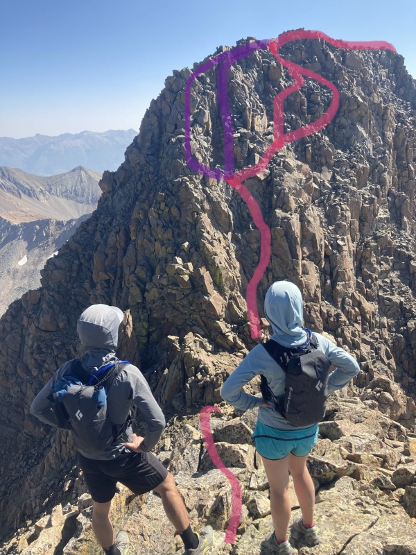
Once you regain the ridge crest, the route-finding is relatively straightforward until you reach the east end of this narrow section and have to drop back down again. This section is pretty narrow and exposed in spots. A few portions reminded me of the knife edge on Capitol. If you enjoy this stretch of ridge (especially the steeply exposed sections), you would probably enjoy the Little Bear -> Blanca traverse! 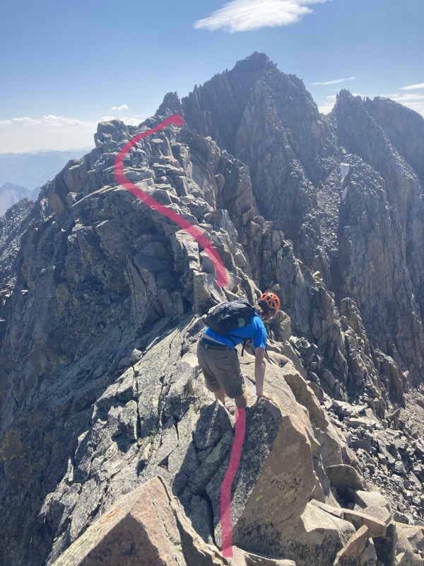
The east end of this narrow section requires some steep class 4 downclimbing and careful maneuvering to reach the saddle where you can see the final gully leading to a small saddle and Mt. Wilson’s summit ridge. Going to the left side of the ridge or downclimbing directly seemed better than anything on the right (south) side of the ridge here. 
At last, we were almost there! An easy (but loose) class 2 gully gets you from the saddle up to the summit ridge on Mt. Wilson. 
From there, solid class 3 and 4 scrambling gets you to the summit itself. The rock is steep, but stay on the ridge or just to the left of it and you’ll get there! 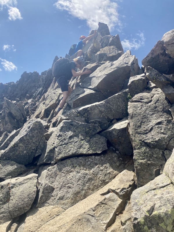

We arrived at the summit of Mt. Wilson around 11:10am and took a nice long break with Melissa and the other couple we had run into. The weather still looked beautiful, sunny and clear! 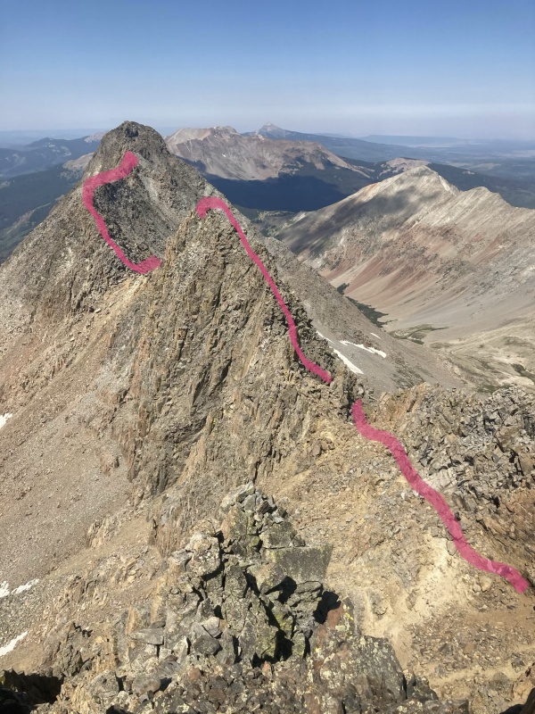
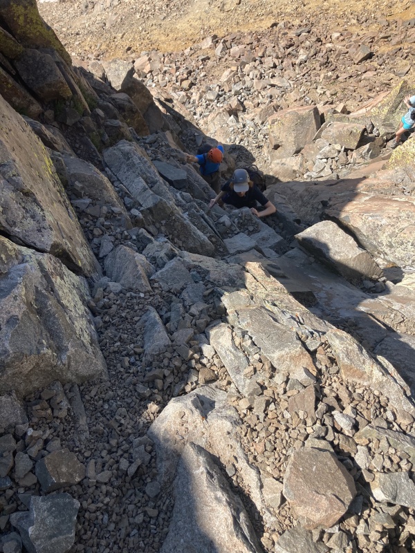
Mt. Wilson descent, via North Slopes route (or at least, we tried) Around 11:45am, Ben, Paris, Melissa and I decided to head down Mt. Wilson to the basin. Our original plan had been to climb El Diente and Mt. Wilson that day (Saturday), and then climb Wilson Peak Sunday before hiking back down to the car. However, we started discussing the possibility of doing Wilson Peak on Saturday as well, since the weather looked amazing and for once, I wasn’t too worried about the classic afternoon thunderstorms rolling in. We decided we would get down Mt. Wilson and then make a decision based on how tired we were feeling. Man, oh man. If only we had known what our Mt. Wilson descent held in store for us. We made it down the summit ridge to the small saddle just fine, and then looked around to see where the rest of the descent trail was. Looking directly down the slope below us, I spotted what I thought was a trail, and we also noticed a few people descending farther down the slope which confirmed my hunch. So, we set off down the slope, which we quickly realized was a loose pile of choss that felt like it just kept getting steeper. What followed was an hour of agony — carefully picking our way down the slope but inevitably knocking down a small rain of dirt and pebbles with every step. It was too steep to scree-ski down for fear of dangerous rockfall, but not steep enough to be downclimb-able solid rock. The perfect choss storm. At one point, one of my companions (who shall remain unnamed) accidentally sent a fist-sized rock hurtling towards my head. 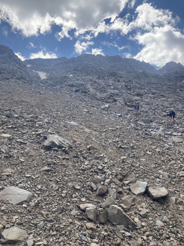
After it seemed like the pain would never end, the slope started to ease slightly, and it looked like we would be able to start cruising instead of meticulously tiptoeing down the mountain. And then, somehow — it got worse. Every step threatened to send a landslide of turkey-sized rocks down the mountain in front of me. To make matters worse, my tears were only making the rocks even more slippery! At long last, the rocks began to solidify and we started traversing to the right (east) as we continued down the slope. We were aiming for a rib of rock where Melissa thought she could spot a cairn in the distance. When we got there and confirmed that there was a cairn and a semblance of a trail, I thought I had never been so happy in my life. Looking back up the slope above us, we realized we had covered a pitiful amount of distance for how long it took us, but at least we were done with it and on to better things! From here, we were able to move much faster as Ben and Melissa led us down the trail. We ran into a few people who had come down the actual North Slopes route, and we realized we should have traversed much farther east across the slopes, instead of barreling straight down the gully below the summit ridge. After reaching the trail, route-finding became much more straightforward, and before we knew it, we had reached the basin! Exhausted from our descent ordeal, we laid down on the grass down by the stream and took a much-needed break as we planned our next move. Melissa decided to return to her camp and head out, since she had a long hike and drive ahead of her before returning home that night. Meanwhile, we took an hour to lay down in the sun, fill up on water, and contemplate whether we should go for Wilson Peak or return to camp for the night and save it for tomorrow. I was feeling pretty beat from the descent, but eventually Paris convinced us to at least try for the peak — we could always turn back if we felt ourselves getting too tired. Wilson Peak, via Southwest Ridge As the mid-afternoon sun baked us alive, we started slogging up the trail toward the Rock of Ages saddle and Wilson Peak’s Southwest Ridge. Besides the heat and copious amounts of sweat dripping down from my hat, it was actually quite a nice hike and I think we all appreciated the straightforward nature of the trail up to the saddle. We took a quick break upon reaching the saddle and decided to keep going for it, but to also take our time since we weren’t worried about weather coming in. 
Once we reached the saddle between Wilson Peak and Gladstone Peak, we took another break and checked out the trail ahead. Paris had hiked Wilson Peak before, so Ben and I let him take the lead as we headed left across class 3 ledges. After the short class 3 section, the trail is reasonably well-defined and pretty solid which was a nice change from our Mt. Wilson descent. It angles up and across the slope, occasionally reaching small breaks in the ridge where you can look out across Silver Pick Basin to the west. 

Eventually, the trail steepens as you climb up to a false summit. From there, the route consists mostly of class 3 downclimbing and scrambling. 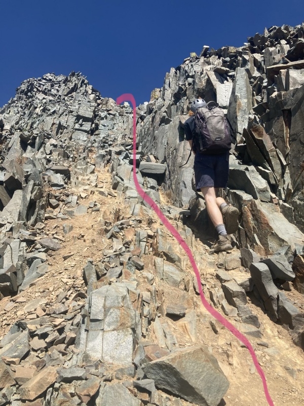
Ben was feeling pretty tired and decided to wait on the false summit while Paris and I pushed on. After a short but steep downclimb, the trail crosses some steep rock before heading up another steep gully. 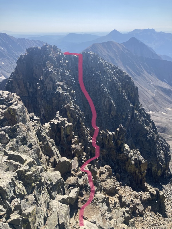

The climbing was fun and went quicker than I expected! At last, we finished the last bit of scrambling and gained the easy summit ridge, walking the rest of the way to the summit. Once atop Wilson Peak at last, I ravenously ate a bunch of Cheezits and somehow-unmelted chocolate in my pack and snapped a few pictures. We took a short break, enjoying the views before heading back to Ben on the false summit. It was nice to finally do a 14er in the afternoon! 
The trip down was pretty casual and we reached our camp around 6pm. Then, it was time for dinner, beers and kicking back as we watched the sun go down. It got a little windy after dinner, so Paris and Ben decided to cram with me into my (2-person, mind you) MSR Hubba Hubba tent. We were all pretty tired, and for some unfathomable reason Ben and Paris decided to sleep right there with me. Luckily, I had secured half of the floor space with my thick camping pad, so I was living in luxury while they fought for the scraps of square footage. In the morning, Paris remarked that he definitely would have slept better outside of the tent. But, at least now we know that it can be a 3-man tent in a pinch! 
Woods descent The next morning, we slept in until 7am or so and hung out for a while before packing up camp and heading down. We left our camp at the base of El Diente a little after 8:30am and cruised down to Navajo Lake — first time seeing it in the daytime! 
I don’t think I would describe the 400’ climb out of Navajo Basin as “gradual” (as others have noted), but it was doable nonetheless and over relatively quickly. After that, we had a beautiful Sunday morning hike back out to the Woods trailhead, only seeing a handful of people on the trail along the way! We were happy to get back to the car and appreciated the water spigot near the bathroom as well! There is nothing quite like the feeling of sliding into a car, cranking the AC and cruising down the road after a jam-packed weekend of backpacking and climbing mountains. We stopped in Gunnison on the way back for a healthy lunch of margaritas, burgers and fries at the Powerstop. And after a few more hours on the road and the obligatory Sunday traffic on Hwy 285, we made it back to Boulder right around 8pm. Overall, it was a great weekend with perfect weather and a fun group of companions. If you’re planning on climbing El Diente from Navajo Basin and are comfortable with some class 4 climbing, the North Buttress is definitely the way to go — going up the loose gully of the standard route looked like a torture I wouldn’t wish on my worst enemies. The traverse was fun, with the second half (starting from El Diente and going to Mt. Wilson) being much more strenuous and technical (and arguably, more fun) than the first half. Going down Mt. Wilson… I’m still not sure how we went so wrong or where we should have turned off, but it was bad. I’m sure there are much better ways to do it — like actually going down the trail — but we totally missed it. And Wilson Peak was a great way to top off the day — mostly class 2 hiking but with some fun class 3 sections to mix things up! Climb times: El Diente North Buttress route: 2hr 15min (left camp 6:30am, arrived El Diente summit 8:45am) El Diente -> Mt. Wilson traverse: 1hr 55min (left El Diente summit 9:15am, arrived Mt. Wilson summit 11:10am) Mt. Wilson descent (via North Slopes route, kind of): 2hr (left Mt. Wilson summit 11:45am, arrived in basin 1:45pm) Wilson Peak Southwest Ridge route: 1hr 40min (left basin 2:36pm, arrived Wilson Peak summit 4:16pm) Wilson Peak descent to camp via Southwest Ridge: 1hr 30min (left Wilson Peak summit 4:30pm, arrived camp 6:00pm) Thumbnails for uploaded photos (click to open slideshow): ")
")
")
")
")
")
")
")
")
")
")
")
")
")
")
")
")
")
")
")
")
")
")
")
")
")
")
")
")
")
")
")
")
")
")
")
")
")
")
")
")
")
")
")
")
")
")
")
")
")
|
| Comments or Questions | |||||||||
|---|---|---|---|---|---|---|---|---|---|
|
Caution: The information contained in this report may not be accurate and should not be the only resource used in preparation for your climb. Failure to have the necessary experience, physical conditioning, supplies or equipment can result in injury or death. 14ers.com and the author(s) of this report provide no warranties, either express or implied, that the information provided is accurate or reliable. By using the information provided, you agree to indemnify and hold harmless 14ers.com and the report author(s) with respect to any claims and demands against them, including any attorney fees and expenses. Please read the 14ers.com Safety and Disclaimer pages for more information.
Please respect private property: 14ers.com supports the rights of private landowners to determine how and by whom their land will be used. In Colorado, it is your responsibility to determine if land is private and to obtain the appropriate permission before entering the property.