Download Agreement, Release, and Acknowledgement of Risk:
You (the person requesting this file download) fully understand mountain climbing ("Activity") involves risks and dangers of serious bodily injury, including permanent disability, paralysis, and death ("Risks") and you fully accept and assume all such risks and all responsibility for losses, costs, and damages you incur as a result of your participation in this Activity.
You acknowledge that information in the file you have chosen to download may not be accurate and may contain errors. You agree to assume all risks when using this information and agree to release and discharge 14ers.com, 14ers Inc. and the author(s) of such information (collectively, the "Released Parties").
You hereby discharge the Released Parties from all damages, actions, claims and liabilities of any nature, specifically including, but not limited to, damages, actions, claims and liabilities arising from or related to the negligence of the Released Parties. You further agree to indemnify, hold harmless and defend 14ers.com, 14ers Inc. and each of the other Released Parties from and against any loss, damage, liability and expense, including costs and attorney fees, incurred by 14ers.com, 14ers Inc. or any of the other Released Parties as a result of you using information provided on the 14ers.com or 14ers Inc. websites.
You have read this agreement, fully understand its terms and intend it to be a complete and unconditional release of all liability to the greatest extent allowed by law and agree that if any portion of this agreement is held to be invalid the balance, notwithstanding, shall continue in full force and effect.
By clicking "OK" you agree to these terms. If you DO NOT agree, click "Cancel"...
| Report Type |
Full |
| Peak(s) |
Culebra Peak - 14,053 feet
|
| Date Posted |
01/06/2021 |
| Date Climbed |
01/02/2020 |
| Author |
cburns9760 |
| Culebra Peak winter 2020 |
|
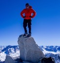
We started out our trip driving from Colorado Springs to the town of San Luis, Colorado. The goal was to get something to eat and get to sleep early so that we could be at the gate for our 6 AM start. Unfortunately, there was not a single restaurant and or a gas station available in San Luis. Luckily we were able to drive 20 miles to the town of Garcia and get some really good Mexican food at Crazy Beaver Bar & Grill (thank god cause I don’t think hot pockets would have spelled a summit the following day). The following day we were greeted by Carlos at the ranch entrance right at 6 AM and follow the road in to headquarters to meet the rest of the crew. After a quick briefing we were on our way to skin up the long road to tree line. I was on a split board and my hiking partner was on skis, it was our goal from the onset to ski/snowboard from 13,000 feet. We were really grateful first for the snowmobile trench all the way to the four-way sign. But after that, it was deep snow and breaking trail all the way to the ridge. Once I was able to get up on the ridge, the winds were blowing 20-40mph, so dropped my snowboard and headed up to the fall summit. From 13,200 feet to the top it was a mix of post holing quite bit & solid rock which was a breath of fresh air. Once I was able to get up to the false summit, winds were sustained it nearly 40 mph but the summit was in site. I was able to reach the summit at 2 PM, which was right about when We wanted to turnaround (sun was headed down quickly). Now the goal was to get back to my snowboard and Jason and I were going to ski/snowboard down. When we set out on this journey we didn’t take into account how our bodies would feel after 6000 feet of gain, snowboarding/skiing sounded great, but was much more difficult then we intended. And this just in, they forgot to run the snow cat above the tree line, so the snow was quite bumpy and unforgiving! we made it back to tree line and worked out way back down the mountain. I will say, that both my climbing partner and myself clocks nearly 16 miles and every bit of 6000 feet of gain. So, Make sure you know what you’re getting into before you sit out on this hike because it is not an easy day. We were able to make it back to headquarters just after 5 PM, where we were greeted once again. All in all it was an amazing day on this glorious Peak, so grateful have climbed it in the winter with my great find and climbing partner Jason! Btw, If you can somehow get up there this week there will be a great long trench all the way to 13,000 feet. Get out there and get it my people, enjoy!
Thumbnails for uploaded photos (click to open slideshow):
")
")
")
")
")
")
")
")
")
")
")
")
|
Caution: The information contained in this report may not be accurate and should not be the only resource used in preparation for your climb. Failure to have the necessary experience, physical conditioning, supplies or equipment can result in injury or death. 14ers.com and the author(s) of this report provide no warranties, either express or implied, that the information provided is accurate or reliable. By using the information provided, you agree to indemnify and hold harmless 14ers.com and the report author(s) with respect to any claims and demands against them, including any attorney fees and expenses. Please read the 14ers.com Safety and Disclaimer pages for more information.
Please respect private property: 14ers.com supports the rights of private landowners to determine how and by whom their land will be used. In Colorado, it is your responsibility to determine if land is private and to obtain the appropriate permission before entering the property.
")
")
")
")
")
")
")
")
")
")
")
")