Download Agreement, Release, and Acknowledgement of Risk:
You (the person requesting this file download) fully understand mountain climbing ("Activity") involves risks and dangers of serious bodily injury, including permanent disability, paralysis, and death ("Risks") and you fully accept and assume all such risks and all responsibility for losses, costs, and damages you incur as a result of your participation in this Activity.
You acknowledge that information in the file you have chosen to download may not be accurate and may contain errors. You agree to assume all risks when using this information and agree to release and discharge 14ers.com, 14ers Inc. and the author(s) of such information (collectively, the "Released Parties").
You hereby discharge the Released Parties from all damages, actions, claims and liabilities of any nature, specifically including, but not limited to, damages, actions, claims and liabilities arising from or related to the negligence of the Released Parties. You further agree to indemnify, hold harmless and defend 14ers.com, 14ers Inc. and each of the other Released Parties from and against any loss, damage, liability and expense, including costs and attorney fees, incurred by 14ers.com, 14ers Inc. or any of the other Released Parties as a result of you using information provided on the 14ers.com or 14ers Inc. websites.
You have read this agreement, fully understand its terms and intend it to be a complete and unconditional release of all liability to the greatest extent allowed by law and agree that if any portion of this agreement is held to be invalid the balance, notwithstanding, shall continue in full force and effect.
By clicking "OK" you agree to these terms. If you DO NOT agree, click "Cancel"...
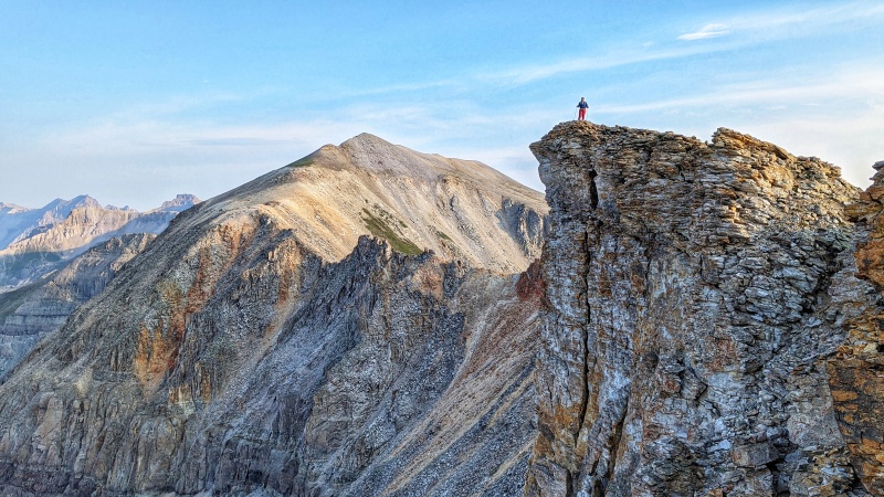
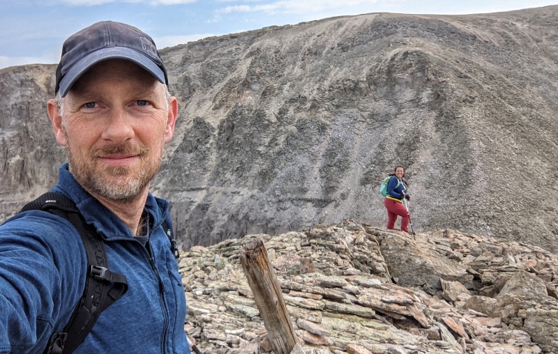
Regina on a point. Chicago Peak in the background.
The plan was to hike “Tomboy Peak,”Chicago Peak, T 7 and T 8 if the weather Gods decided to cooperate. This was a birthday trip for Regina that would also entail driving Imogene Pass. Neither one of us had any intention of walking the road. I’ve personally, been off-roading for a long time. I’ve heard of Imogene and I was excited to finally get up there and navigate it and to see the famed Tomboy Mine.
Unfortunately, T 7 (13,359’) and T 8 (13,317’) ended up falling off the radar due to time constraints (we had to get the rented Jeep back into Ouray by 4:00 pm). But Chicago and “Tomboy” didn’t disappoint.
Knowing the Telluride (west) side was supposed to be extremely exposed with multiple shelf sections, we decided to leave Telluride at 4:30 am in order to not run into anyone else on the road. That turned out to be a great idea as we never ran into anyone. We had the road and pass all to ourselves!
Even driving super slow across the palisades (at one point, I thought I was going to scape the entire drivers side of the Jeep) it took us just over two hours to drive to the top of the pass, and that includes stopping at different points for pictures.
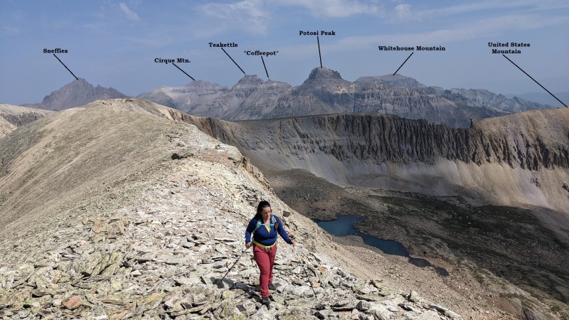
Once at the top (13,114’), we drove along the wide crest for no more than a couple hundred meters (give or take) and parked the Jeep. From the top, one can easily see T 7 and T 8, Chicago Peak, the Sneffels Range, Telluride Peak and Fort Peabody (super interesting!).
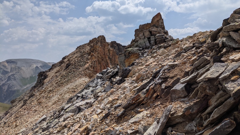
The ridge starts out fairly mellow. There is some old mining debris you have to weave around but eventually, the mellow dirt turns into choss. The traverse is about one mile to the summit of Chicago Peak. Roughly half-way across the ridge, the terrain gets super crumbly, loose and fractured. I think it may go at class-2+. To the southwest, the ridge disappears into sheer cliffs. To the northeast, it’s loose, rocky slope. There are some minor pinnacles along this section but everything is avoidable by staying on the northeast side. There is a social trail of sorts, but it drunkenly disappears into the choss as soon as you find it only to reemerge later along the ridge. If loose rock doesn’t bother you, you’ll have fun with this. If loose rock isn’t your cup of tea, you probably won’t care for this section.
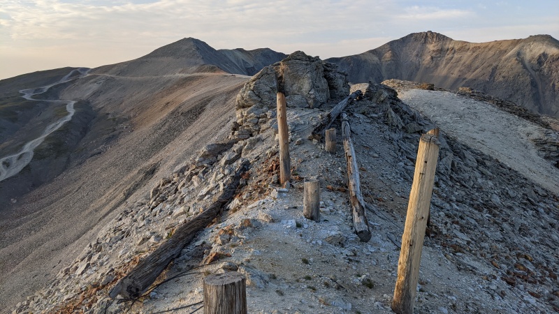
After we passed the class-2+ section, the ridge switches back to easy alpine slopes. We made the summit of Chicago Peak easily by 7:45 am. The smoke made pictures kind of pointless. After a quick bite to eat, we kicked on. We stayed to the easy ridge for another .5 mile until the satellite ridge leading over to “Tomboy” came up. From this main ridge, we contoured southwest and started to drop down losing altitude to the saddle. We dropped 436’ to the addle. This descent was loose. Nothing on this shoulder seemed even remotely stable. The saddle had some recent wood pikes from, I’m assuming recent mining or property surveying.
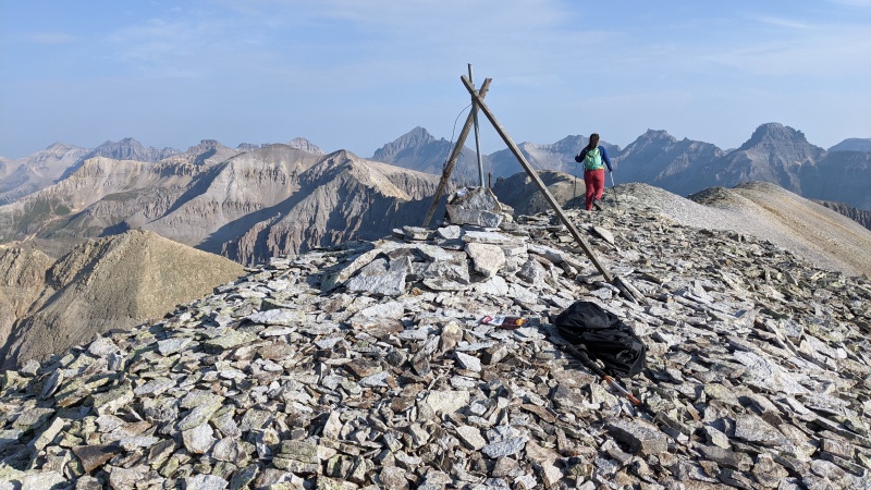
The good thing about “Tomboy Peak,” is that from the saddle, it only rises 321’. The rock is of slightly better quality too. We stayed for a while as the views were quite good. I rebuilt the cairn and replaced the old, broken register.
Thinking we were still going to try for T 7, we made haste out of there and retraced our steps. I scampered and climbed up a couple small pinnacles on the way back to work my climbing legs and fingers but gave up after the second pinnacle. The holds were just too "portable" for my comfort, some really rotten rock. But alas, by the time we made it back to the Jeep, we decided getting T 7 wouldn’t be a good idea. The ridge back took longer than we expected and the drive down the east side of Imogene took longer as well. But, with all the mines up there and some amazing waterfalls, sometimes it’s best to take Plan-B and enjoy the scenery.
2,443 elevation gain
4.2 miles
Leaving Chicago PeakLooking back at Imogene PassThe ridge past Chicago. A MASSIVE rock glacier on the Ouray side of the passSummit of "Tomboy Peak"Looking back at Imogene PassChossy rock
Thumbnails for uploaded photos (click to open slideshow):
I did a jeep tour to Imogene Pass from Ouray and onto Telluride last Fall, believe me when I tell you that when the guide stopped the Jeep at the pass, I just wanted to start hiking all those peaks and leave him. :)
That is such a beautiful area but the access point is tricky and I am glad you had the skills to drive the Jeep! It is not an easy road. Thank you for sharing!!
Caution: The information contained in this report may not be accurate and should not be the only resource used in preparation for your climb. Failure to have the necessary experience, physical conditioning, supplies or equipment can result in injury or death. 14ers.com and the author(s) of this report provide no warranties, either express or implied, that the information provided is accurate or reliable. By using the information provided, you agree to indemnify and hold harmless 14ers.com and the report author(s) with respect to any claims and demands against them, including any attorney fees and expenses. Please read the 14ers.com Safety and Disclaimer pages for more information.
Please respect private property: 14ers.com supports the rights of private landowners to determine how and by whom their land will be used. In Colorado, it is your responsibility to determine if land is private and to obtain the appropriate permission before entering the property.


")
")
")
")
")
")
")
")
")
")
")
")
")
")
")
")
")
")
")
")
")
")
")
")