| Report Type | Full |
| Peak(s) |
"Ferguson Peak" (11,509) |
| Date Posted | 09/20/2021 |
| Modified | 10/15/2021 |
| Date Climbed | 09/05/2021 |
| Author | k_fergie |
| Ferguson Peak - Lost River Range - ID |
|---|
|
"Ferguson Peak" (11,509 feet) Group: Me, my dad, Steve Grantham, Alex Feldman, Tammy Burns, Bill Burns, Sean Burdick, Tom Lopez (partial) Date: 09/05/2021 I know that this isn't a Colorado peak, or even as high elevation as many trailheads here, but I thought I'd post my TR on 14ers anyways. Just in case anyone here is thinking about climbing some obscure peaks out of state that see generally 1 or fewer ascents per year. And so that they can feel so blessed for our compartively solid rock quality compared to what ensued for me this Labor Day Weekend. Ferguson Peak (UN 11509) is an unofficially named peak in the Lost River Range of Idaho, approximately 10 miles SE of Mt. Borah, Idaho’s highest peak. The standard approach, if you could say that there is one, is to enter the Lost River Range through Dry Creek Road and Long Lost Creek Road from the east side. The Long Lost Creek road is a semi-difficult 4x4 road, probably a 3/6 on the 14ers.com scale. Maybe Subaru-able, but it would tough. Simple for a standard 4x4 with some driver experience. We took this road to its terminus, far up the Long Lost Creek drainage, and there were ample camping locations along the road and near the Swauger Lakes TH. After some discussion with Steve and Alex, who had climbed this peak way back in 2005, we elected for a loop route. Although, in retrospect, the easiest way would have been to use the Swauger Lakes trail in both directions (see screenshotted map, Photo 1). It wouldn’t have made too much of a difference, given the off-trail hiking through rough rock required either way, so might as well loop it. 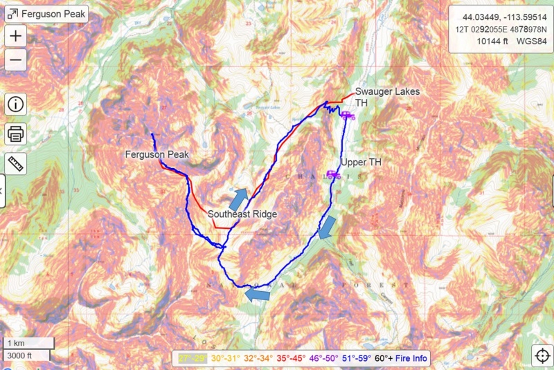
Photo 1: Overview map of our route (blue) and my estimation of the “standard” SE ridge route (red). Ample camping along the road near the two indicated trailheads. Our chosen loop route had us leave camp and follow the Long Lost Trail #194 up the Long Lost Creek drainage for 1.5 miles or so. The Forest Service topo maps list this trail as trail #194, however, the sign at the start of the trail by camp listed it as #094. We left the trail in a sagebrush filled meadow and aimed generally north up a gully feature and towards a pass (now known by me as Breakfast Pass) to enter a basin south of Ferguson’s long southeast ridge (Photos 2 – 6). From here, we intersected the “standard” southeast ridge route from Swauger lakes, our planned descent route. A steep ~800 foot climb up to the ridge awaited us (Photo 7). Once we gained the ridge, it looked like we would be quite close, oh how we were so wrong! We gained the ridge at approximately 11,100 feet and the summit was only at 11,500 feet. However, I forgot to truly take note of Tom’s wise words about the “never-ending” southeast ridge of Ferguson. We only had a net gain of about 400 feet to go, however, the summit was over 1.5 miles away from us and not even close to in view, with many false summits and terribly loose rock guarding the true one. We collected ourselves and prepared for the loose ridge to come. See Photo 15 for overview of the ridge. 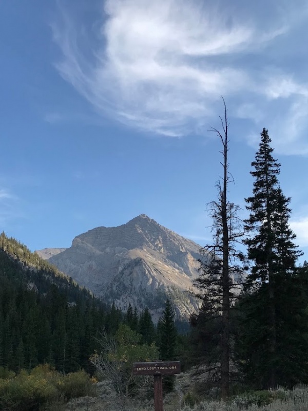
Photo 2: The start of the trail at the end of the Long Lost Creek road and camp site. Shadow Lakes Peak looking majestic towering over the valley. 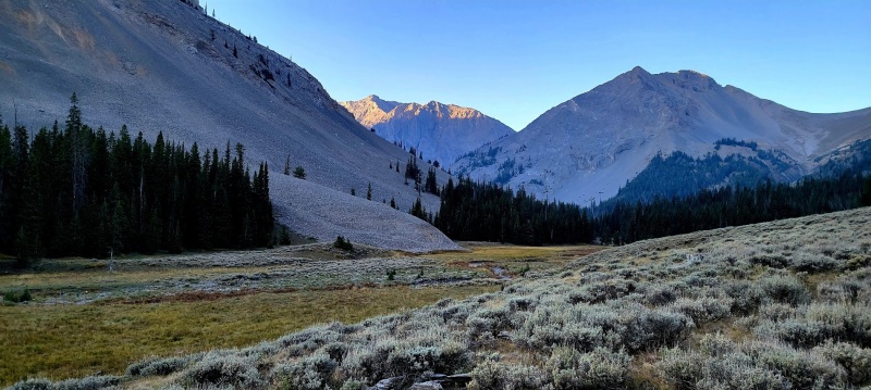
Photo 3: Approximate location where we left Long Lost Trail and bushwhacked north, up a steep gully towards the S ridge of Ferguson. USGS Peak (left) and Castle Peak (center-right) 
Photo 4: The group heading off-trail towards Ferguson. We aimed for the stand of trees at the saddle at the top of the gully, just illuminated by the morning light. 
Photo 5: The range is reportedly full of fossils, but we noticed a high concentration of them in this gully. 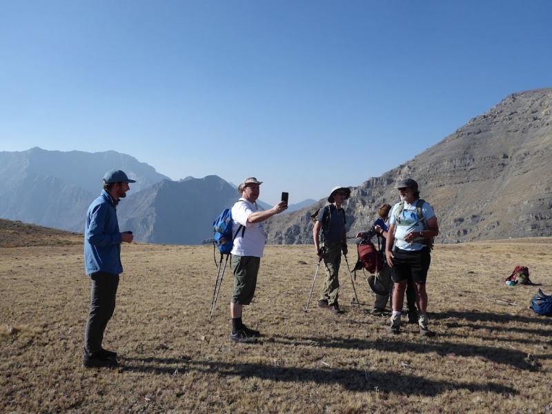
Photo 6: Breakfast break up on a flat pass, ~10,250 feet. We came up the gully behind where the group is standing. 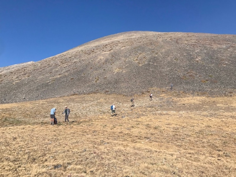
Photo 7: Climbing up from the pass ~800 feet to gain Ferguson’s south ridge at the top of the photo. Here, I will pause to note that I consider myself a relatively experienced climber/mountaineer/hiker/whatever-you-want-to-call-it, and I’ve dealt with some pretty loose rock before. Of course there is always more to learn, and that is my favorite part of climbing, but I've been around the block at least once. But honestly, nothing prepared me for what was to lie ahead, there is very minimal beta on this peak, as less than 30 people have ever climbed it, half of them family or friends. This ridge is very tame and quite enjoyable class 1 or 2 walking for 90% of it, but the final ridge difficulties afforded some serious class 3, R-rated level scrambling on terribly loose rock, like nothing I’ve seen before. It made the rotten rock of the Teakettle/Coffeepot or Maroon Bells areas seem as solid as the granite on Longs Peak. Bring the gaiters and be prepared to hate yourself for about 30 minutes to 1.5 hours of this climb. I was not mentally ready and that likely contributed to the suck factor. I guess for some reason the fact that we heard intermittent distant rock fall the whole time we were in base camp didn’t clue me in to what lay ahead. 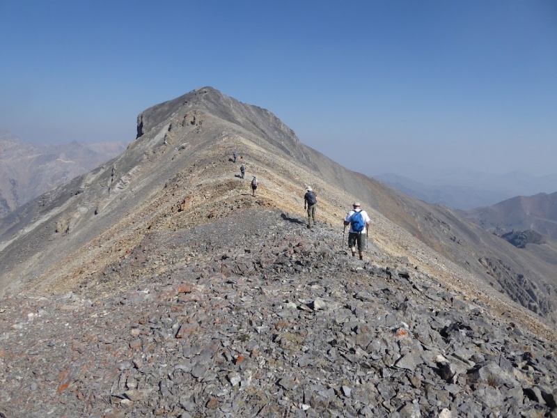

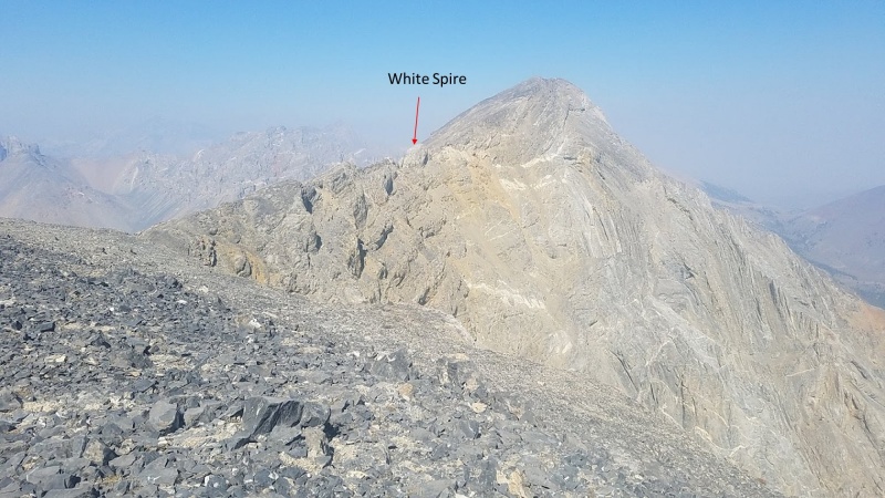
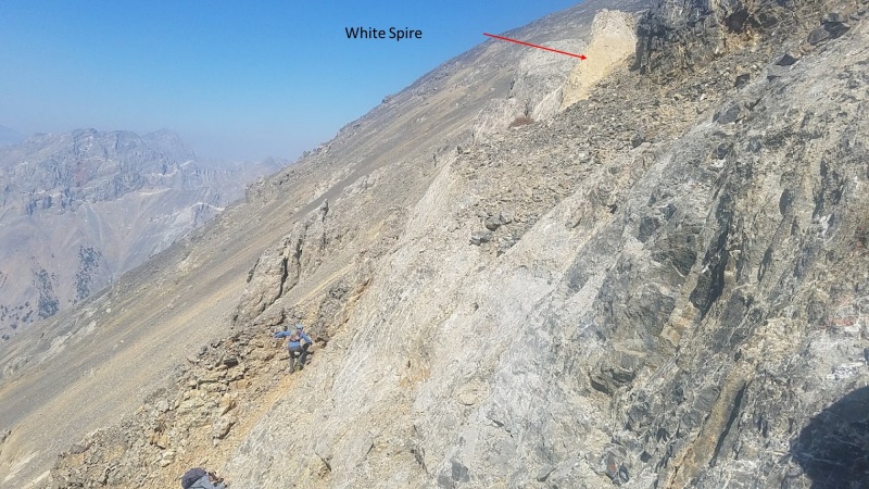
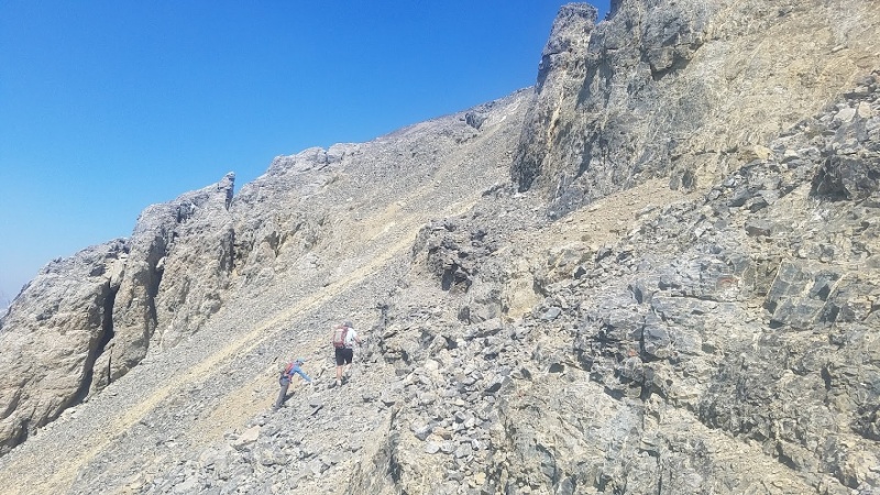
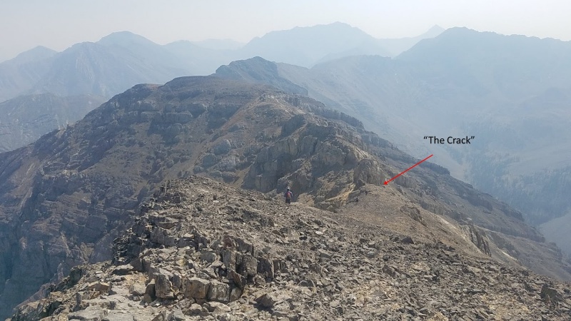
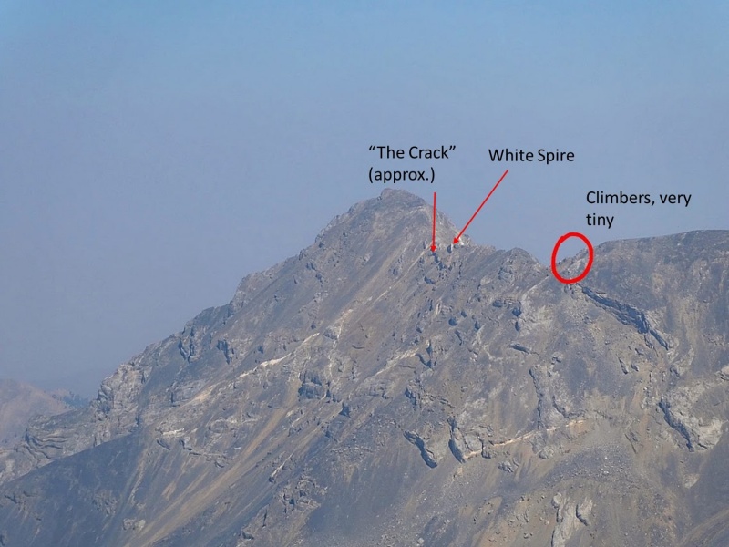
Like I was saying, we had a very long ridge ahead of us, and I’m positive the views of the greater Lost River Range would have been absolutely spectacular were it not for the thick smoke we were dealing with. Ferguson is on paper not very prominent, only about 700 feet of prominence above its saddle with The Moat. But this doesn’t capture how prominent it feels while you are climbing it because on the other 3 sides, Ferguson has nearly 3000 feet of prominence above the valley floors, with steep San Juan-esque views of large slide paths and rock glaciers. The first 80% of the ridge is fast moving and you stay entirely ridge proper with a couple very short sections of class 2+ down climbs (Photo 10). In places, the ridge is quite narrow and there are some easy catwalks that feel quite thrilling given the exposure. Once gaining a large, flat false summit with an elevation of approximately 11,300 feet, you get a great view of the final pitch and rugged difficult section of ridge. Photo 11 shows the difficulties, but not the route since the route takes you down the west side that is slightly less steep and loose as the east side shown in the photo. Continue down and along the ridge proper, increasing in difficulty to class 3 until you reach a point where staying ridge proper would be awful, loose class 4/5 climbing. We made it almost to the white spire labeled in the photos below. Just before here, we dropped down to the west side (climber’s left) and bypassed some of the large cliffs by a class 3-R down climb that somehow had a cairn at the top (see Photo 12). After the initial loose down climb away from the White Spire, continue traversing along the cliffs and try to locate a large crack in a cliff that blocks your way. Accessing this crack, and staying as close to the ridge crest as possible, will significantly limit your exposure to the loose crumbling cliffs surrounding you. We, however, could not locate this crack on the ascent, having only a word-of-mouth description of the location. Therefore we had to drop even lower, around some seriously loose ribs and cliffs, class 3-R (see Photo 13). Bypassing the cliffs and ribs, we eventually reached a climbable gully that could take us back up to the ridge crest. We climbed and plunge-stepped up this gully, reached the ridge crest, emptied the scree out of our boots, and completely the rest of the ascent to Ferguson’s summit. At the top of this gully there is a ledge system that leads to “The Crack”, the life-saving bypass we used on the way down, saving us much time and effort. Hopefully with photo documentation, someone can now better utilize this feature (see Photos 14-16, 20). 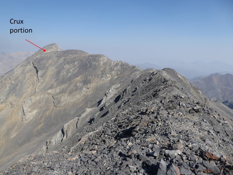

Having reached the top, we set about erecting a temporary plaque that Steve made, providing a little history on the peak (see Photos 18, 19). My great uncle, Chuck Ferguson, completed the first known ascent of this peak in 1978, reportedly while on a horse-packing trip in the area. This story makes sense given the most capable off-road car Chuck ever owned was a 1960’s VW Bug. Without 4x4, the mileage of climbing this peak would be in the upper 30’s or even higher, you’d probably have to start at the Pass Creek – Dry Creek junction (an extra 14 miles each way). Chuck and his brother David (my grandfather) were among Idaho’s earliest mountaineers and pioneers of the ultra-endurance sports scene (Nike released it's first running shoes in the 1970's, after they got into marathon running). Each having completed over 100 marathons, one of the first Leadville Trail Race 100’s (1984, I believe), and several other ultra-marathons. They were the first known Idahoans to finish the Colorado 14ers (August of 1998 on Castle Peak). Chuck has at least 4 known first ascents in Idaho (Ferguson, Brocky, Pegasus, and Straight Shot). Chuck and Dave made the first ascent of Brocky peak (ID’s 22nd highest peak) together in 1994 via the Class 5 South Ridge. Subsequent mountaineers have since located an easier Class 4 route on the South face. Although neither Chuck nor Dave were able to finish Idaho’s 11ers (114 ranked summits), I think that a couple first ascents ain’t bad. Tragically, Chuck died unexpectedly of a heart attack late in 1998, a few months after finishing the CO 14ers and crossing 100 marathons, just goes to show that being young and healthy sometimes isn’t enough.  Photo 18: The summit crew, left to right. Steve Grantham, myself, my dad, and Alex Feldman. Steve, Alex, Dave (my grandfather), and a few others climbed this peak in 2005 and spread Chuck’s ashes on its summit. From then on, it has unofficially been known as Ferguson Peak. It is in the process of being officially named, although there is a significant backlog. This past summer (2020), my grandfather passed away from Alzheimer’s after a period of poor health at the age of 81. This trip was in his memory, and we spread his ashes with his brother’s on Ferguson’s summit. And just like he would’ve wanted for his memorial climb, this peak was a brutal climb, a sub-group of us got lost, and I ran out of water several miles away from the TH. After some earlier trips in his life with unnecessarily heavy packs, grandpa made a new rule that you couldn’t end a hike with any food or water left over; it was just wasted weight to be carried without being used. And he lived it. Steve and Alex recalled one trip where they went on a 4-day peak bagging expedition in a remote part of Idaho where my dad and grandfather carried just a box of Ritz crackers, a large hunk of cheese, a large summer sausage, a single Nalgene each, and a water filter for the totality of their nutrition for the trip. Some original fast-packing technique from the 80’s. However, this technique was not fool-proof and he did end up spending several quite uncomfortable, unplanned nights out, most notably three nights overdue on a PCT section in the CA Sierra Mountains. 
Photo 19: The Ferguson Peak temporary summit plaque. After we paid our respects and packed everything up, we decided we should probably get moving since we were already quite a bit later than planned. And in grandpa Ferguson’s fashion we had elected to not bring any headlamps (too heavy, not very useful especially if there is a full moon). We retraced our route along the long ridge, except finding “The Crack” on the return trip. After finishing the ridge and getting back to Breakfast Pass, we elected to head down towards the Swauger Lakes trail by following the drainage and staying high on a talus bench (Photos 22, 23). The terrain here was rough and there were several cliff bands on the backside of the bench that we had to navigate before we reached the Swauger Lakes trail. Having been out of water for some time, I was relieved to reach the trail, knowing that we only had 2-ish miles of trail until we were back to the car. The trail miles went down quickly and we returned to the car without much more to note.  Photo 20: “The Crack” on the descent. A very nice, class 3 fissure in a cliff that would otherwise by impassible. Very hard to find on the way up. This bypass allows one to stay closer to ridge crest and avoid the loose mess that we had to drop down and fight on our way up.  Photo 21: Incredibly cool folding on Shadow Lakes Peak seen from near the summit of Ferguson.  Photo 22: Approximate descent down towards the Swauger Lakes trail. This descent route make it a loop adventure. The pass where we ate breakfast is marked for reference.  Photo 23: Picking up sections of trail-like-objects as we descend towards Swauger Lakes trail (located behind the bench). Staying high and gaining this bench prevents following the drainage down, losing more elevation, and getting lost in thick woods.  Photo 24: Ferguson’s complicated (read: completely unexplored) SE face as viewed from Swauger Lakes. Overall, this was a great trip and it meant a lot to me for many reasons, but was the climb itself a fun one? I’m not so sure to be honest. Would I recommend it friends? Only the ones that really like a good sufferfest. The 12 miles RT and 4,800 feet of gain felt like a lot more than the stats suggest. I was cooked even though the weekend prior I had done a 17 mile, 6k gain day in the Gore without much issue. The terrain is incredibly rough limestone, there’s very little trail, and the rock on the ridge is the worst I’ve ever seen, although Steve and Alex (both Idaho 12er and 11er finishers, two of less than ten) said it is typical quality for the Lost River Range. I guess we are spoiled out here in Colorado. Would I do it again? Of course. When do you get the chance to climb a peak that has seen less 30 total visits ever, less than 1 visitor per year since it was first climbed in 1978? Not too often. Trip Grade: A Road Difficulty: 3/6 on 14ers.com standards. Overall, a pretty easy road with a few minor difficulties. Not Subaru-able unless you’re willing to throw your car around a fair amount. Places with deep ruts would have a Subaru dragging in the center. A few loose sections where I found 4-low quite helpful, although maybe not necessary if you just sent it and risked bottoming out for going too fast. Climb:
Thumbnails for uploaded photos (click to open slideshow): ")
")
")
")
")
")
")
")
")
")
")
")
")
")
")
")
")
")
")
")
")
")
")
")
|
| Comments or Questions | ||||||||||||
|---|---|---|---|---|---|---|---|---|---|---|---|---|
|
Caution: The information contained in this report may not be accurate and should not be the only resource used in preparation for your climb. Failure to have the necessary experience, physical conditioning, supplies or equipment can result in injury or death. 14ers.com and the author(s) of this report provide no warranties, either express or implied, that the information provided is accurate or reliable. By using the information provided, you agree to indemnify and hold harmless 14ers.com and the report author(s) with respect to any claims and demands against them, including any attorney fees and expenses. Please read the 14ers.com Safety and Disclaimer pages for more information.
Please respect private property: 14ers.com supports the rights of private landowners to determine how and by whom their land will be used. In Colorado, it is your responsibility to determine if land is private and to obtain the appropriate permission before entering the property.