Download Agreement, Release, and Acknowledgement of Risk:
You (the person requesting this file download) fully understand mountain climbing ("Activity") involves risks and dangers of serious bodily injury, including permanent disability, paralysis, and death ("Risks") and you fully accept and assume all such risks and all responsibility for losses, costs, and damages you incur as a result of your participation in this Activity.
You acknowledge that information in the file you have chosen to download may not be accurate and may contain errors. You agree to assume all risks when using this information and agree to release and discharge 14ers.com, 14ers Inc. and the author(s) of such information (collectively, the "Released Parties").
You hereby discharge the Released Parties from all damages, actions, claims and liabilities of any nature, specifically including, but not limited to, damages, actions, claims and liabilities arising from or related to the negligence of the Released Parties. You further agree to indemnify, hold harmless and defend 14ers.com, 14ers Inc. and each of the other Released Parties from and against any loss, damage, liability and expense, including costs and attorney fees, incurred by 14ers.com, 14ers Inc. or any of the other Released Parties as a result of you using information provided on the 14ers.com or 14ers Inc. websites.
You have read this agreement, fully understand its terms and intend it to be a complete and unconditional release of all liability to the greatest extent allowed by law and agree that if any portion of this agreement is held to be invalid the balance, notwithstanding, shall continue in full force and effect.
By clicking "OK" you agree to these terms. If you DO NOT agree, click "Cancel"...
The plan was to scale Gilpin Peak. If conditions allowed, and why wouldn’t they considering how abundantly dry and warm it has been, I’d saunter on over and try my hand at Mt. Emma. From there, I could descend either into Yankee Boy just west of Stony Mountain (12,698’), or descend due east and catch the mining road down into Governor Basin and back out. It seemed like it would be a good, long and fulfilling day. Though, as most of us know all too well when things don’t go according to plan, “Man plans, God laughs.”
For those looking to trek up into Yankee Boy this winter, here’s the hard stats:
Gate to the first fork (Camp Bird Road): 1.5 miles
Gate to #869/Imogene Pass: 2.5 miles
Gate to Revenue/Virginus Mine: 2.7 miles
Gate to Governor Basin fork: 3.5 miles
Gate to Outhouse: 4.2 miles
Gate to Sneffels 4wd Trailhead: 6.0 miles
I’ve more or less stopped listening to music for those long, winter approaches when the lower gates are closed (save for The Grateful Dead). Instead, I’ve found that podcasts tend to whistle away the hours almost unperceivably. My mind is just too distracted to note the passage of yet, ‘another section’ of road. On this cold September, going on December morning, I was able to burn through some episodes of the 1949 St. Louis exorcism (of which William Peter Blatty’s book, ‘The Exorcist’ is based off), Planet Money & Lore. Before I knew it, I was at Wrights Lake and the Sneffels Trailhead. It was just past dawn; I was making great time.
I didn’t do any research on Gilpin Peak. I figured, wrongly, from the many times I’ve been to Blue Lakes Pass, one simply follows the ridge south to Gilpin’s northern flanks followed by an easy scramble to the summit ridge. Easy peasy, right? Well, it wasn’t.
Once I left the pass, I made it .2 mile across this ‘flat ridge’ climbing over some surprisingly and wholly unexpected steep spires. I got stopped by a large middle-finger of rock seemingly giving me the ‘bird.’ Both sides of the ridge held steep, calcified smooth snow. I leaned forward over the tip balancing on my hands, feet slightly in the air to get a better look around the fingernail of rock. I was shocked. I could see easier terrain about 30’ ahead but getting there wasn’t. I rocked back down onto my feet, looked downward to the west side and descended about 15’ on exposed nubs of rock. I took four steps out onto the snow, silently cursed and promptly backtracked. Just getting my axe planted took a couple punches and my feet weren’t purchasing at all. I had flashbacks of my slide/fall on American Peak the prior spring and didn’t feel like revisiting that lesson. I retraced back to the pass and sat down, grumbling.
I didn’t have crampons. I didn’t bring them because honestly, I didn’t think I would need them. I had a hunch that any snow I might have come across, would be bulletproof. That was confirmed earlier in the morning as I crossed hardened tracts of snow like shingles patches. The streams, frozen mercurial veins of silver were astonishingly still running. Even despite the snow conditions, I figured I’d be able to skirt anything that looked devious along the upper ridge.
Keep in mind, I ended up scrambling Mt. Sneffels the day before the last big storm. Conditions now are of course, radically different. The skies above were still calm and blue. There was no way in hell I was going to trek 6.5 miles up here just to turn around and walk back down. I looked over at Sneffels and noticed the SW Ridge was like, 95% snow-free. Again, I expected it to be dryer than Gilpin’s north facing route, but I didn’t expect it to be in [early] fall conditions. I wanted to write a report on Gilpin Peak, not Sneffels. So this report serves mostly to relate distances to anyone venturing into Yankee Boy this winter. I hope it helps!
I shouldered my pack, cinched my straps and started up towards Sneffels. This was my third time doing the route. ‘Well,’ I thought, ‘Gilpin might not be in the cards today, but there’s always Plan-B.’
I noticed there were tracks off to my left below in the snow. The snow patch extended up towards the palisades. I would eventually have to cross it but I had -8,000% interest in descending to catch the track. I chopped (quite literally) holds into the icy concrete with my axe and gingerly made my way across until I reached the shallow moat. From there, I just followed it to the edge of where the snow ended. As with the spicy ridge at Blue Lakes Pass, I had to plunge my axe several times just to get it to puncture through the snow.
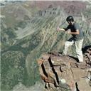
Dallas PeakThe SW Ridge from Blue Lakes Pass
I passed the snowy tissue of the pass and reached dry rock. For those who haven’t done this route before, it is in my opinion one of the state’s best 3rd class routes (another being the ridge north from Iron Nipple to UN 13,555).
The SW Ridge is:
Easy to follow
Ascends a fair amount of elevation (~1160’)
Encompasses a good mix of loose/solid rock
Has incredible views for most of its length
At roughly 13,465’, a pair of short gullies present themselves. I believe this obstacle is what warrants the 3rd class rating (maybe the crux?). The right-hand gully is the easier of the two and easier for shorter people. The left gully has a few long reaches.
A short ways past this, I came to a couloir one must descend to wrap around a massive gendarme. I turned in and downclimbed the snow. It’s deeply etched into the eastern side of the ridge so the fact that it was holding snow didn’t come as much of a surprise. The ascent couloir on the other side is more open and faces more to the south, it was snow-free if not muddy.
Back at the ridge and after another 50’ or so of easy, loose scrambling, the disordered jumble was done. I could see the summit and perhaps a few hundred feet of solid, enjoyable scrambling, not unlike of what’s found on N. Eolus
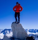
Top of Lavender Col
I stayed on the summit for perhaps 30 minutes taking in the warmth of the sun and actually enjoying the light, emphysemic breeze. I cleaned out the summit register, left new paper (the old ammo magazine is still there), finished my beer and started the descent.
The crux at the col was filled in. Not really wanting to step down onto a tilted slab which, at 6’ tall, I could have easily done, I elected to wedge myself into the left side crack and lower myself down onto a small snowy ledge.
The upper col was still holding snow with a thick bottom layer of water ice. It was tricky business descending since the ice showed through like abrasions on the snow. But all things considering, I still made it back down to the upper basin in 35 minutes. I was rather please with that since the clouds were now rolling in.
For a day where my initial plans got derailed, things turned out alright. I made it back down to the truck as the incoming storm turned the skies pewter and left the Ouray Brewery just as the first flakes descended.
The crux at the top of Lavender ColIs this September or early December????
Thumbnails for uploaded photos (click to open slideshow):
...of your day - making the Plan B work out! You should have hit me up Kiefer. I would have given you my story of the largest rock slide I've ever started; as it was on Gilpin (you were right wanting to do that peak with snow). We should try to get up something this spring or summer! You and the wife have a great holiday season!
Jay, itlFish99, Will & Brad. Much appreciated! Thanks for reading.
Caution: The information contained in this report may not be accurate and should not be the only resource used in preparation for your climb. Failure to have the necessary experience, physical conditioning, supplies or equipment can result in injury or death. 14ers.com and the author(s) of this report provide no warranties, either express or implied, that the information provided is accurate or reliable. By using the information provided, you agree to indemnify and hold harmless 14ers.com and the report author(s) with respect to any claims and demands against them, including any attorney fees and expenses. Please read the 14ers.com Safety and Disclaimer pages for more information.
Please respect private property: 14ers.com supports the rights of private landowners to determine how and by whom their land will be used. In Colorado, it is your responsibility to determine if land is private and to obtain the appropriate permission before entering the property.


")
")
")
")
")
")
")
")
")
")
")
")
")
")
")
")
")