Download Agreement, Release, and Acknowledgement of Risk:
You (the person requesting this file download) fully understand mountain climbing ("Activity") involves risks and dangers of serious bodily injury, including permanent disability, paralysis, and death ("Risks") and you fully accept and assume all such risks and all responsibility for losses, costs, and damages you incur as a result of your participation in this Activity.
You acknowledge that information in the file you have chosen to download may not be accurate and may contain errors. You agree to assume all risks when using this information and agree to release and discharge 14ers.com, 14ers Inc. and the author(s) of such information (collectively, the "Released Parties").
You hereby discharge the Released Parties from all damages, actions, claims and liabilities of any nature, specifically including, but not limited to, damages, actions, claims and liabilities arising from or related to the negligence of the Released Parties. You further agree to indemnify, hold harmless and defend 14ers.com, 14ers Inc. and each of the other Released Parties from and against any loss, damage, liability and expense, including costs and attorney fees, incurred by 14ers.com, 14ers Inc. or any of the other Released Parties as a result of you using information provided on the 14ers.com or 14ers Inc. websites.
You have read this agreement, fully understand its terms and intend it to be a complete and unconditional release of all liability to the greatest extent allowed by law and agree that if any portion of this agreement is held to be invalid the balance, notwithstanding, shall continue in full force and effect.
By clicking "OK" you agree to these terms. If you DO NOT agree, click "Cancel"...
| Report Type |
Full |
| Peak(s) |
Culebra Peak - 14,053 feet
|
| Date Posted |
02/06/2022 |
| Date Climbed |
02/05/2022 |
| Author |
laddymac |
| Culebra after a storm yikes |
|
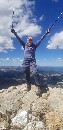
Hiked with Ric Rozenkranz and Tracy Anderson. We started at the check-in Cabin at 6:30am. The road to the Four Way was "groomed" by snowmobiles. The ridged pattern made by the tracks is less than smooth, but it's better than breaking through a foot of fresh snow for four miles. After that, we continued on the ATV trail with just boots/micro spikes. We were breaking trail for the first time since the latest storm. The snow was about 12" deep. Once the ATV trail ended, we broke into snowshoes crossing the creek and traversed the west facing slope of the sub peak into increasingly deeper snow, with drifts reaching 36" in places. Several times, the snow would crack and break away in three-foot sections giving you that mini avalanche feel. As we rounded the south facing portion is when things got difficult. The wind really started coming at us hard from the west and north. The footing underneath became extremely unreliable. For three feet you were post-holing, followed by 6 feet of snow frozen so hard you couldn't get a grip with micro spikes. It was hard to know what to have on your feet because there was no right answer. Ric and Tracy brought poles which were very helpful to tripod oneself, although, there are many hidden nooks in the snow/rock and one pole was broken off. There was much stumbling and cursing. This was also the time that while I was changing into crampons, my gloves blew away and are in Nebraska right about now. Ric had a backup pair thankfully. Although we were only at 12,500 feet, it was by far the most fatiguing and emotionally draining stretch of the day. We reached the saddle and stored our packs to lighten our load for the last push. Once we began the ascent along the final ridges and the three false summits, the edge was a mix of drifts and bare rock with enormous horizontal icicles coming off of every rock. The wind was hitting us full-on at 40 mph and you could lean into it without falling over. We had to scream just to communicate over the howl. We were very thankful to be wearing heavy snow pants, lots of layers, using hand-warmers, face coverings, and ski goggles. We could only tolerate one minute at the top, just enough time for a photo op. On the return, we opted to stay higher on the southern and west-facing sub peak to avoid the crazy mixed surface area below that had caused so much suffering and frustration on the way up. However, that meant we were descending in extremely deep snow, 3-4 feet in places. We opted to slide down on our butts for portions of it. As the sun was going down, we crossed the creek and needed headlamps to see. At the Four Way, we were drained but had hope that civilization was only four miles away and we were able to get into a rhythm for the first time in nine hours. We finished at exactly 13 hours, completely drained. See video: https://drive.google.com/file/d/1cksIav62GdTn-9N2Xpcw1-v7YDeGKTDL/view?usp=sharing
Thumbnails for uploaded photos (click to open slideshow):
")
")
")
")
")
")
")
|
Caution: The information contained in this report may not be accurate and should not be the only resource used in preparation for your climb. Failure to have the necessary experience, physical conditioning, supplies or equipment can result in injury or death. 14ers.com and the author(s) of this report provide no warranties, either express or implied, that the information provided is accurate or reliable. By using the information provided, you agree to indemnify and hold harmless 14ers.com and the report author(s) with respect to any claims and demands against them, including any attorney fees and expenses. Please read the 14ers.com Safety and Disclaimer pages for more information.
Please respect private property: 14ers.com supports the rights of private landowners to determine how and by whom their land will be used. In Colorado, it is your responsibility to determine if land is private and to obtain the appropriate permission before entering the property.
")
")
")
")
")
")
")