Download Agreement, Release, and Acknowledgement of Risk:
You (the person requesting this file download) fully understand mountain climbing ("Activity") involves risks and dangers of serious bodily injury, including permanent disability, paralysis, and death ("Risks") and you fully accept and assume all such risks and all responsibility for losses, costs, and damages you incur as a result of your participation in this Activity.
You acknowledge that information in the file you have chosen to download may not be accurate and may contain errors. You agree to assume all risks when using this information and agree to release and discharge 14ers.com, 14ers Inc. and the author(s) of such information (collectively, the "Released Parties").
You hereby discharge the Released Parties from all damages, actions, claims and liabilities of any nature, specifically including, but not limited to, damages, actions, claims and liabilities arising from or related to the negligence of the Released Parties. You further agree to indemnify, hold harmless and defend 14ers.com, 14ers Inc. and each of the other Released Parties from and against any loss, damage, liability and expense, including costs and attorney fees, incurred by 14ers.com, 14ers Inc. or any of the other Released Parties as a result of you using information provided on the 14ers.com or 14ers Inc. websites.
You have read this agreement, fully understand its terms and intend it to be a complete and unconditional release of all liability to the greatest extent allowed by law and agree that if any portion of this agreement is held to be invalid the balance, notwithstanding, shall continue in full force and effect.
By clicking "OK" you agree to these terms. If you DO NOT agree, click "Cancel"...
Peak Eight: North Slopes/Northeast Ridge from 11,400' in Vestal Basin
Approximately 8 miles and 4000 vertical feet from camp in lower meadow for the peak
Introduction
Most of you probably have seen by now that newer LiDAR based surveys have been changing our beloved peak lists. North Maroon is ranked, Challenger Point is not. The Highest 100 had some shakeup as Trinity and Arrow replaced Dallas and Teakettle. Very few people have made it through this with their list completions intact. 13er finishers who climbed all of the soft ranked 13ers still have to go back for promoted 12ers. I was fortunate enough to have climbed all of the 12ers that got promoted, but along the journey I had missed several of the soft ranked 13ers that have now been bumped up to ranked peaks. So far this summer I have been fortunate enough to have managed to pick up some clean up peaks, and even refinish a few county and Wilderness peak lists.
My friend Lindsay is working on her Centennial list and we had been talking for months about heading into Vestal Basin together to get Vestal, Arrow and the Trinities. Her friend Kendall joined up for the trip to round out a solid group of three. If there was time, I was hoping to make the trek out to Peak Eight and clean up one of my LiDAR orphans, as a back up I would skip the Trinities repeat head for Eight while they did those. We packed in on Saturday of the July 4 weekend, knowing that the weather wasn't great to start. Sunday ended up being a washout, it pretty much rained all morning, and aside from a few quick walks around the valley we spent a lot of time in our tents. Monday was a great day, we were able to ascend Wham Ridge on Vestal, and the weather held for us to also add Arrow on the way back to camp. Tuesday was our only remaining climbing day before a Wednesday pack out, so my plan B was put in motion and I would head over to Eight while Lindsay and Kendall went up the Trinities.
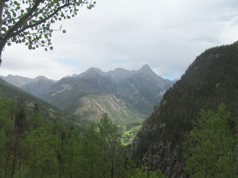
I won't go into the details of how to get to Vestal Basin, there is plenty of information on this approach. I will say that the approach is in pretty good shape this year so far, the Colorado Trail from Molas to the beaver ponds is strong and all of the old avalanche debris is cleared. As usual, there is plenty of deadfall to navigate on the Vestal Basin trail, but the trail is easy enough to follow and far better than other similar climbers' trails in the area. The climbing gear for Wham weighed us down a bit and the last mile to camp was slow, so it was a welcome relief to reach the 11,400' meadow below Wham to set up our basecamp for the next few days.
View from Pack In
Approach from Vestal Basin
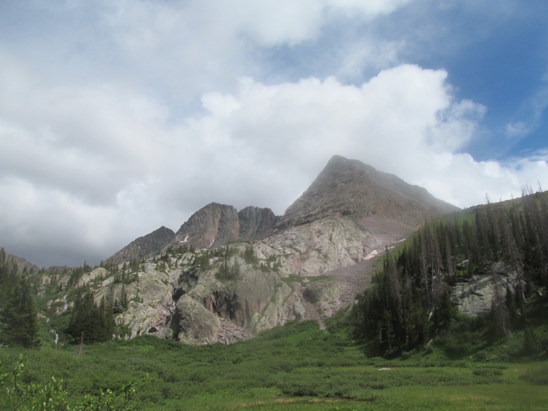
Tuesday we woke up early to beat out any potential afternoon rains, and headed up the climbers' trail out of camp towards the upper 11,700' meadow in the dark by our headlamps. The creek crossing was higher than it was last time I in the basin, but we managed it okay. We hugged the bottom edge of some willows and headed up through a more treed area to minimize the willows and picked up a second climbers' trail partway up the slope.
Trinities from upper meadow - route goes up through trees on right
This got us up above treeline before it fizzled out in the wide flats between Vestal and West Trinity as the sun became bright enough for us to put the headlamps away. Our goal was the nearly 12,900 saddle towards the base of West Trinity's west ridge.
Upper approach (taken 2019) - saddle is to left side
Around 12,600 the slope steepens to a loose talus/scree slope. Staying right initially in some bigger rocks was reasonably stable until we could intercept a use trail that cuts diagonally across the slope where it almost reaches the saddle before entering the scree gully. Here we parted ways after a snack, it was about 6.15 and the morning clouds were still lingering. Nothing looked too threatening, so we went forward hoping for the best.
300-ish feet of junk to saddle
From the saddle, I had to traverse below the Trinities and then some, almost all the way to Storm King. To reach this area, some people choose to follow a line noted on CalTopo as the Kodiak High Route. This route is not a trail, but rather a high traverse across the scree and talus below the Trinities. Having been to Balsam Lake in 2019 via this same saddle, I knew that there was as grassy game trail 600' below and instead dropped straight down the grass to pick up this trail. Stay left and you will find a couple of cairns marking this trail. It is not particularly strong, but does make progress quickly despite fading out a few time.
View from game trail, note that the low saddle just left of center is Storm King-Nine saddle
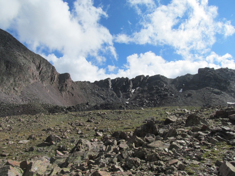
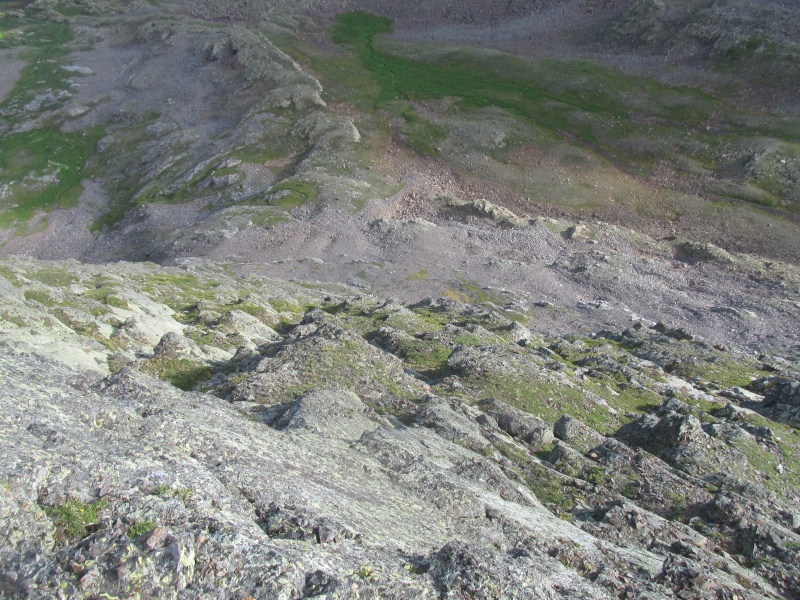
You lose a little more elevation and meet up with a trail that comes out of Balsam Lake at about 11,800'. There is a small creek drainage here that leads into a nice basin ringed by peaks Seven, Eight, Storm King and East Trinity. The trail starts good, but fades out.
The route is reasonably obvious through here as you stay on a slight rise that splits between two high tarns around 12,100. This rise helps keep you out of willows and wet marshy grass. At the east end of the southern of these tarns, cross the meadow and ascend an even more defined rise that is a mix of grass and slab as it curves towards 12,600' at the base of Peak Eight's north face.
North face of peak Eight
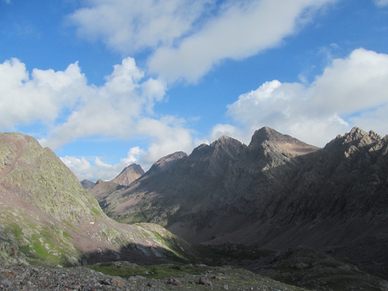
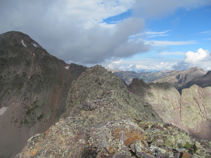
Here the terrain begins to steepen and its a good place for a break in the rocks. While snacking I noticed Lindsay and Kendall on the summit of West Trinity. We had radios so we could communicate throughout the days and I radioed to say hello.
Trinities and Vestal from break spot
Peak Eight Climb
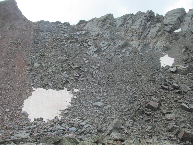
As Roach might say if he had Peak Eight in one of his books, the introduction is over. There are two ways to approach the upper ridge from this point. One is to traverse east to a northeast facing scree gully that splits Eight and its eastern false summit. Being July 5, I expected that way would have a fair amount of snow still so I went with the second option. The north face of Peak Eight is a series of steep grass and rock and with careful route finding you can find a way to zigzag to the base of the ridge on the highest of these ledges with no more than a few easy class 3 moves.
Ledge system from below
If you keep going up and left, you eventually pop out at the saddle between Eight and its eastern false summit, where I could see from above that indeed the gully was snow filled.
Ledges from above
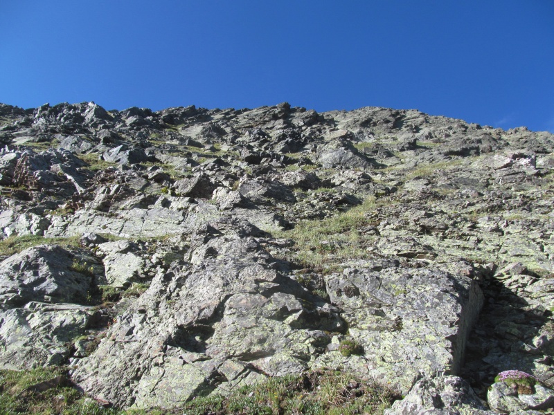
I stashed the poles here and engaged in the class 3 northeast ridge. The ridge starts out steep, but is not too exposed. I mostly stayed on the ridge crest, which was a lot of fun to climb.
Ridge ascent
Ridge ascent continues
The ridge levels off and it becomes clear that the summit is not where the topo map has it marked, but is rather towards the west end and looks much higher. This may be the difference in the map (13,228') and LiDAR (13,252') elevations that result in this peaks' promotion to ranked.
True summit (the bigger peak beyond left is Peak Seven)
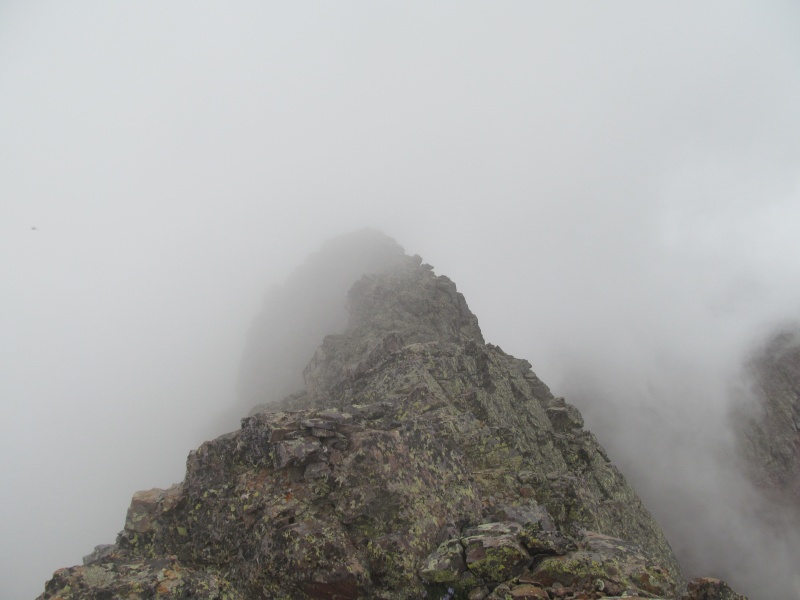
The exposure level increases here, but the scrambling is solid and remains class 3. It took about 5 minutes to get to the highest point and in that 5 minutes a cloud from the Leviathan Creek drainage to the south rose dramatically out of the valley and began to envelope me in an eerie fog.
Leviathan basin from near summit
I radioed my friends that I was on the summit as they were now progressing towards Trinty. The fog kept me from spending too much time on the summit, and I retraced the ridge in the fog.
True summit from roughly the same spot as earlier photo, about 10 minutes between these two photos. The fog rolled in fast!
Return to Camp
I descended the steeper lower ridge back to the grassy ledge system and down to the basin below where I worked my way back towards the slopes below the Trinities. Here we radioed each other again to check weather as the south gully between Middle and East was my friends' bail point if needed. They felt good and were going for East, so I kept going to re-find the climbers' trail and head back to the West Trinity saddle, which required roughly 1100' of total regain along the way, the last 600' of which are the steepest.
Grassy traverse, you can just make out the thin trail
Another radio check-in with my team when I reached the saddle and they were on East Trinity, I decided to traverse high below West Trinty's north face to hopefully meet them at the tarn below the Trinities. I generally stayed between 12,200 and 12,300 as I navigated numerous slabs and grass ramps. They arrived at the lake shortly after I did and we hiked back to camp together, getting hit with some rain on our way and some larger storms later at camp. One last evening in camp and we packed out the next morning where we reached the car about 10 minutes before the first rains of the day. A successful trip and all of us managed to reach our peak goals despite not being an ideal weather weekend. Already looking forward to the next one, with plans for Jagged and Peak Ten in about 2 weeks!
Rainbow over the Trinities from camp
Thumbnails for uploaded photos (click to open slideshow):
Thanks Eddie and Tommy! Hopefully this will be useful for people who now have to add Peak Eight to their lists! I tried to keep it vague enough to give people an idea of the route and what they are getting into while letting them still have the fun of exploring a peak that has low traffic and low beta. Its a pretty fun mountain and a worthy addition to the 13er list, enjoy it when you get there!
Papi told me you did Eight from Molas. That is a heck of a slog! Nice to share other peak goals with your friends. I got Eight via Leviathan Creek on Monday, which worked out quite well! Also, for other Lidar Peak Eight orphan pursuers, the south couloir works well as a descent route if you're doing it from Leviathan Creek. It's soft scree, but would suck worse than the N couloir to go up.
Randy and I were on Peak Three when that fog rolled over E Trinity vicinity. IT was cool to see from our perspective!
Wish I had seen you in there Mike, other than the specks I saw on Arrow that afternoon. We camped right above the creek crossing used to gain the treed slope for WT/Vestal saddle. Great spot and perfect for groups interested in only Trinities and/or Three & Two.
Thanks for the report and not putting lines and arrows on your photos.
I was on Peak 8 about a week after you, though I came in from Silex Lake. Interesting to see a nice route into that area from the west. Neat little summit ridge, isn't it? Seems like everyone is after the promoted peaks this year. When I returned to Hunchback Pass, the Climbing Cooneys had signed the register at the TH indicating they were heading in for Peak 8 too.
Caution: The information contained in this report may not be accurate and should not be the only resource used in preparation for your climb. Failure to have the necessary experience, physical conditioning, supplies or equipment can result in injury or death. 14ers.com and the author(s) of this report provide no warranties, either express or implied, that the information provided is accurate or reliable. By using the information provided, you agree to indemnify and hold harmless 14ers.com and the report author(s) with respect to any claims and demands against them, including any attorney fees and expenses. Please read the 14ers.com Safety and Disclaimer pages for more information.
Please respect private property: 14ers.com supports the rights of private landowners to determine how and by whom their land will be used. In Colorado, it is your responsibility to determine if land is private and to obtain the appropriate permission before entering the property.


")
")
")
")
")
")
")
")
")
")
")
")
")
")
")
")