Download Agreement, Release, and Acknowledgement of Risk:
You (the person requesting this file download) fully understand mountain climbing ("Activity") involves risks and dangers of serious bodily injury, including permanent disability, paralysis, and death ("Risks") and you fully accept and assume all such risks and all responsibility for losses, costs, and damages you incur as a result of your participation in this Activity.
You acknowledge that information in the file you have chosen to download may not be accurate and may contain errors. You agree to assume all risks when using this information and agree to release and discharge 14ers.com, 14ers Inc. and the author(s) of such information (collectively, the "Released Parties").
You hereby discharge the Released Parties from all damages, actions, claims and liabilities of any nature, specifically including, but not limited to, damages, actions, claims and liabilities arising from or related to the negligence of the Released Parties. You further agree to indemnify, hold harmless and defend 14ers.com, 14ers Inc. and each of the other Released Parties from and against any loss, damage, liability and expense, including costs and attorney fees, incurred by 14ers.com, 14ers Inc. or any of the other Released Parties as a result of you using information provided on the 14ers.com or 14ers Inc. websites.
You have read this agreement, fully understand its terms and intend it to be a complete and unconditional release of all liability to the greatest extent allowed by law and agree that if any portion of this agreement is held to be invalid the balance, notwithstanding, shall continue in full force and effect.
By clicking "OK" you agree to these terms. If you DO NOT agree, click "Cancel"...
Ah yes, Ellingwood Point, Blanca's often-overlooked little brother. My wife and I had been thinking of doing this route for a year or two now, but finally got around to it on labor-day weekend.
The adventure started out better than expected when we found out the road to Zapata Falls had been paved since last time we were there 2 years ago. We camped overnight and woke up just after 6:00 a.m. the next morning for a 7:15 a.m. start time because we were both feeling speedy and confident.
A nice view of the Sand Dunes early on in the trail as it rises away from the trail to the Falls.
The trail going up through the forest was a solid 5/10. Better than walking Lake Como Rd., with its infamous "baby head" rocks, but I would disagree with the "great condition" description mentioned in the route description on this site. There are plenty of loose rocks scattered on the trail. I found myself watching my footing more often then enjoying the scenery.
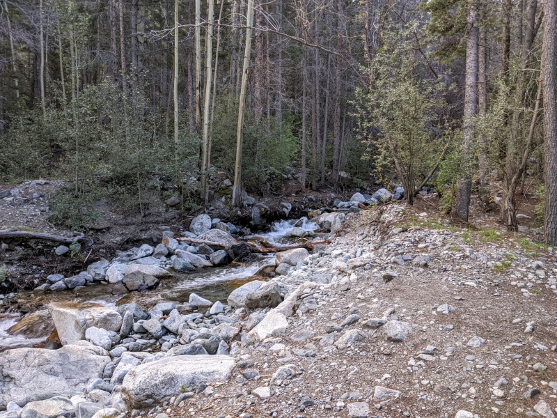
The first of two creek crossings. This mix of sand/half-buried rock/loose rock was more or less constant on the trail below the treeline.
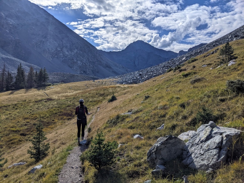
After a few miles and ~2,500 feet of elevation gain, the trail finally exited the treeline and opened up to a spectacular basin with Ellingwood visible at the end.
Out of the trees and into the basin!
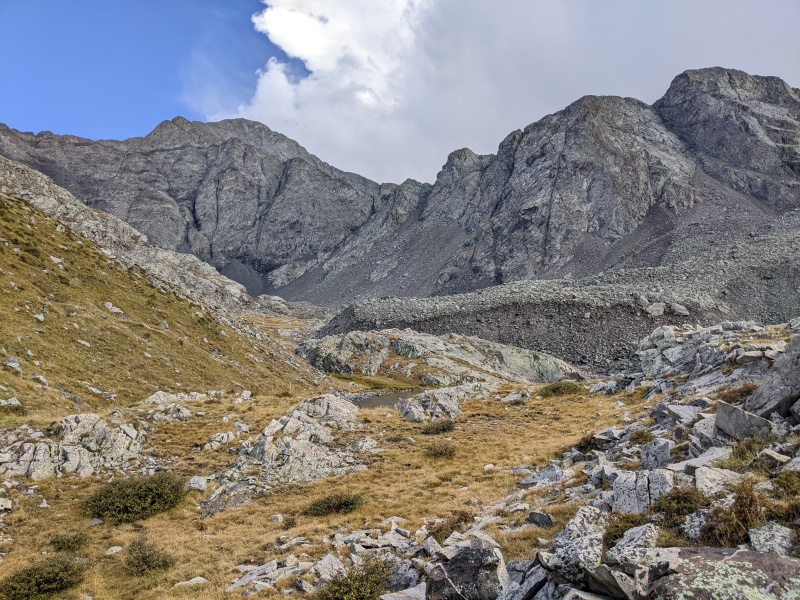
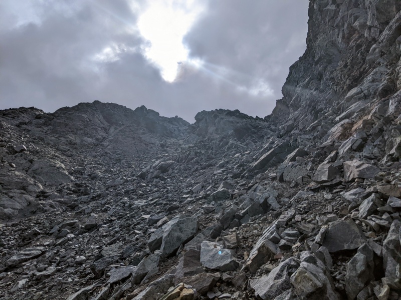
However, any joy that I had of reaching this point and enjoying the view was quickly tempered by the impending doom that was the C2 couloir. 1000 ft. of sandy, rocky mess lay in front of us, and the closer I got the more I was dreading it.
Approaching South Zapata Lake, with Ellingwood and the couloirs to the ridgeline behind.A better view of the C2 couloir from closer.
The route description on 14ers.com focuses on describing the differences between the C2, C3, and no-no C1 "Crossfire" couloir. Very useful for route guidance, but failing to capture the utter misery that is the C2. Starting off, the bottom third of this couloir is generally unsteady, tippy talus. After that, as the description mentions, you can acsend to the right and climb up more stable rock. This middle section is the easiest part of C2. However, in the upper third section - once the couloir starts narrowing down to its point - its composition changes to a compact sand/rock mix. You can still stay to the right to find more rock, but, as opposed to the rocks in the middle section, the rock up here is more brittle and has a vexing tendency to have a 1-3 mm. layer of sand covering it. And this is the steepest section.
About 3/4 of the way up C2 couloir. See the lovely loose rocks and sand?
Yet, despite my sour mood, my wife and I finally made it to the top of the couloir and onto the ridgeline.
At the top of C2 couloir looking at the rideline to Ellingwood
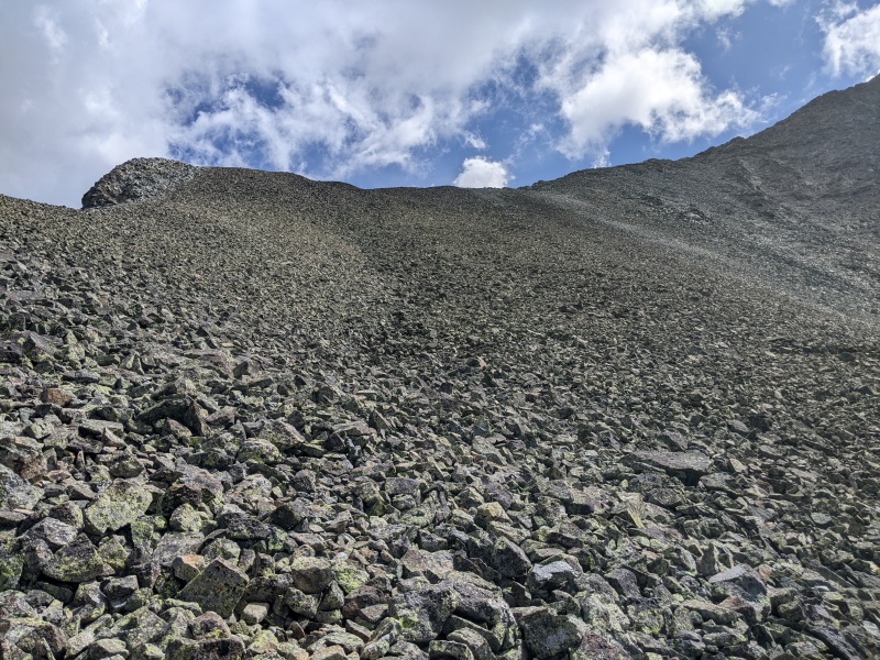
Once on the ridgeline, there was a bit of a climb to get to a turn in the ridgeline. At this turn, another disappointing obstacle appeared. It was clear that to ascend to the final portion of the ridgeline it was necessary to climb up another talus field. There was nothing particularly dangerous or terrible about this talus field - it was just a boring, tedious, and non-scenic trudge up 500 ft. of tippy rock.
More tedium to come...
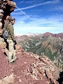
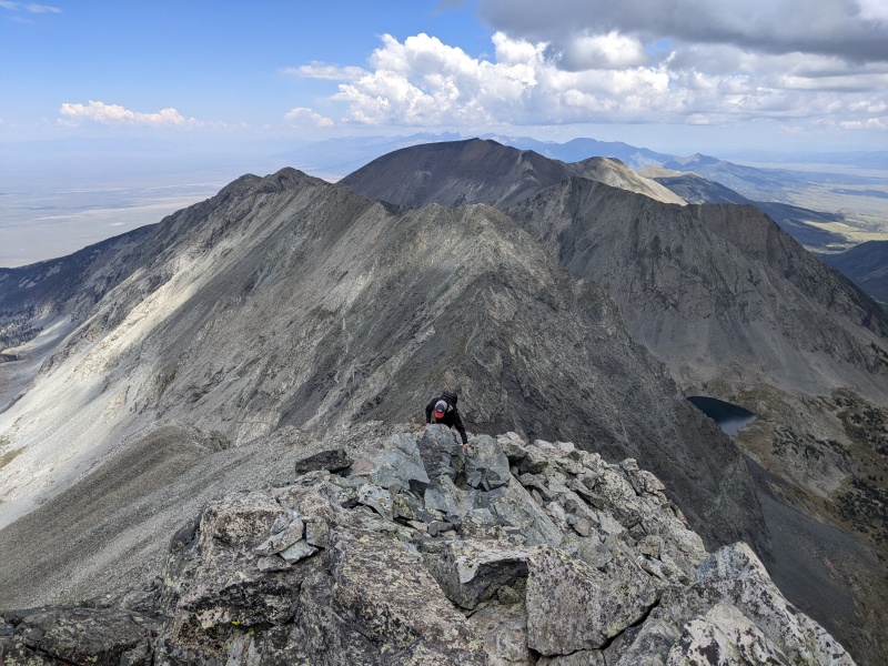
Alas! After the push up the talus field, the route turned into the enjoyable ridge scramble I had been looking forward to all along. Scenic views, fun class 3 moves, all topped off with a grand 360 degree view of the Sangres at the top of Ellingwood.
One of the fun, Class 3 portions on Ellingwood's upper ridgeline.Finally at the summit, enjoying the most Colorado-y of all IPAs, the Voodoo Ranger.
My GPS Tracks on Google Maps (made from a .GPX file upload):
Haha, yes, I noticed that after the fact! I'd already done Como Rd. when I did Blanca, so I wanted to try something different. If you've already done Como and want to try something new it might be worth a shot - but if you haven't and are looking to knock out Blanca and Ellingwood at the same time I'd stick to Como Rd.
I'm sure I'm in the minority when I say that I didn't think the C2 was all that bad. I've done it twice in summer conditions and I bet Randy is right that it would be more enjoyable in snow. The part of that hike that I thought was the worst was the stuff above C2 - that you titled "More tedium to come". That seemed to go on forever.
Could not agree more on your opinion of this route. I completed this route back in early June and honestly hated every minute of it. We made our way up C2 and had snow for the last 2/3 of the climb. I found it extremely sketchy and high consequence. After the never ending scree to the summit of Ellingwood, we made our way over to Blanca. Just picking lines that went around the icy and snow covered talus. After the summit of Blanca and regaining Ellingwood, I vowed that I would not go down C2. We began looking for the C3 gully (using photo 9 from the route description) and scrambling over the never ending scree to get there. Right as we descended into C3 (so we thought), we instantly knew the gully did not go due to its loose nature. We tried to climb out and spent around 10 minutes loosing each foot trying getting back onto safer ground. Turns out that photo 9 is mislabeled on 14ers.com and C3 is over one couloir over than the picture indicates. Finally got down to the lake and spent the next 3.5 hours slogging down and back to the car. Terribly long day and don't think I'll be back to Zapata.
Good work doing Zapata! Did Little Bear via Como Lake several years ago (ATV'd up the road) and vowed to never go back. A couple of years ago (COVID lock-down time frame) I tried Zapata Creek, and got as far as the top of C2 before weathering and timing out. Went back to Como Road with the ATV again this past week (5-8 Sep) to do Blanca and Ellingwood Pt. The road seemed worse than before-but I am a few years older and found out I had COVID when I got home. The climbs up the peaks were fun and spectacular. Been there, done that...again...and glad I don't need to go back!
I also did this route late last summer, and had the same experience with the C2 couloir. It was slow, unpleasant and downright dangerous, especially on the descent. Even if youre very sure-footed, the potential for rockfall from above is quite high. I regretted doing the Zapata Creek approach and would highly recommend just stomaching the long approach from Lake Como.
Caution: The information contained in this report may not be accurate and should not be the only resource used in preparation for your climb. Failure to have the necessary experience, physical conditioning, supplies or equipment can result in injury or death. 14ers.com and the author(s) of this report provide no warranties, either express or implied, that the information provided is accurate or reliable. By using the information provided, you agree to indemnify and hold harmless 14ers.com and the report author(s) with respect to any claims and demands against them, including any attorney fees and expenses. Please read the 14ers.com Safety and Disclaimer pages for more information.
Please respect private property: 14ers.com supports the rights of private landowners to determine how and by whom their land will be used. In Colorado, it is your responsibility to determine if land is private and to obtain the appropriate permission before entering the property.


")
")
")
")
")
")
")
")
")
")