Download Agreement, Release, and Acknowledgement of Risk:
You (the person requesting this file download) fully understand mountain climbing ("Activity") involves risks and dangers of serious bodily injury, including permanent disability, paralysis, and death ("Risks") and you fully accept and assume all such risks and all responsibility for losses, costs, and damages you incur as a result of your participation in this Activity.
You acknowledge that information in the file you have chosen to download may not be accurate and may contain errors. You agree to assume all risks when using this information and agree to release and discharge 14ers.com, 14ers Inc. and the author(s) of such information (collectively, the "Released Parties").
You hereby discharge the Released Parties from all damages, actions, claims and liabilities of any nature, specifically including, but not limited to, damages, actions, claims and liabilities arising from or related to the negligence of the Released Parties. You further agree to indemnify, hold harmless and defend 14ers.com, 14ers Inc. and each of the other Released Parties from and against any loss, damage, liability and expense, including costs and attorney fees, incurred by 14ers.com, 14ers Inc. or any of the other Released Parties as a result of you using information provided on the 14ers.com or 14ers Inc. websites.
You have read this agreement, fully understand its terms and intend it to be a complete and unconditional release of all liability to the greatest extent allowed by law and agree that if any portion of this agreement is held to be invalid the balance, notwithstanding, shall continue in full force and effect.
By clicking "OK" you agree to these terms. If you DO NOT agree, click "Cancel"...
| Report Type |
Mini |
| Peak(s) |
Mt. Sneffels - 14,155 feet
|
| Date Posted |
05/01/2023 |
| Modified |
05/02/2023 |
| Date Climbed |
04/30/2023 |
| Author |
dedicateddave |
| Sneffels - Snake Couloir |
|
Started at 3am at the weehawken trailhead. Hardtail mountain biked up 4 miles and 1900feet on dry roads as high as we could (to the Revenue-Virginus mine). Stashed bikes, transitioned to skis at 5am. Skinned up and had good conditions. Was able to skin up without ski crampons all the way to the saddle/bottom of lavender col. Good sporty scramble up to summit ridge. Summited at about 9:45am.
Rappelled down using preset sling anchors using 60m rope. (Probably down-climbable if necessary.) Skied the snake with good soft snow conditions up high, a little icy just above the crux/dogleg, and then skier's choice corn or pow under the crux depending on which side you ski. Only mild sloughing up high and easy to manage. Skied far right and transitioned at 11:15am. Snow was warming quickly and the ascent of the eastside of lavender col saddle wrapped at 12:45pm. I would not have wanted to be on that slope any later than 1pm in those temperatures (thankfully, we even had 20% cloud cover on that slope, which helped our cause).
Transitioned, and skied nice butter back down the west side of the lower lavender col apron. Skied/double-poled all the way back to Bikes. Transitioned. High-fived. Ripped the bikes all the way back down to weehawken trailhead and ended at 3pm. Roundtrip: 12hours car to car. 17 miles. 7200 vertical feet.
Safety: I will include photo of mountain forecast for this day. If the weather is similar, I would not recommend being on that lavender col east slope any later than 1pm. It was getting wet and I would not recommend ascending in those conditions. We saw some wet slide activity in surrounding SE facing slopes, but did not experience any slide ourselves.
Safety: the road from revenue mine back down to weehawken trail was strewn with mega-icefall and large rockfall. Under no circumstances should you linger on this road in the afternoon, as we had to dismount our bikes and walk over 2 large deposits of ice and rock, each easily weighing hundreds, if not thousands of pounds.
GAIA Track: https://www.gaiagps.com/datasummary/track/25091aac9acc40f8d127c578ae6c78ec/?layer=GaiaTopoRasterFeet
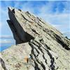
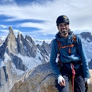
Thumbnails for uploaded photos (click to open slideshow):
")
")
")
")
")
")
")
")
")
")
")
|
Caution: The information contained in this report may not be accurate and should not be the only resource used in preparation for your climb. Failure to have the necessary experience, physical conditioning, supplies or equipment can result in injury or death. 14ers.com and the author(s) of this report provide no warranties, either express or implied, that the information provided is accurate or reliable. By using the information provided, you agree to indemnify and hold harmless 14ers.com and the report author(s) with respect to any claims and demands against them, including any attorney fees and expenses. Please read the 14ers.com Safety and Disclaimer pages for more information.
Please respect private property: 14ers.com supports the rights of private landowners to determine how and by whom their land will be used. In Colorado, it is your responsibility to determine if land is private and to obtain the appropriate permission before entering the property.
")
")
")
")
")
")
")
")
")
")
")