Download Agreement, Release, and Acknowledgement of Risk:
You (the person requesting this file download) fully understand mountain climbing ("Activity") involves risks and dangers of serious bodily injury, including permanent disability, paralysis, and death ("Risks") and you fully accept and assume all such risks and all responsibility for losses, costs, and damages you incur as a result of your participation in this Activity.
You acknowledge that information in the file you have chosen to download may not be accurate and may contain errors. You agree to assume all risks when using this information and agree to release and discharge 14ers.com, 14ers Inc. and the author(s) of such information (collectively, the "Released Parties").
You hereby discharge the Released Parties from all damages, actions, claims and liabilities of any nature, specifically including, but not limited to, damages, actions, claims and liabilities arising from or related to the negligence of the Released Parties. You further agree to indemnify, hold harmless and defend 14ers.com, 14ers Inc. and each of the other Released Parties from and against any loss, damage, liability and expense, including costs and attorney fees, incurred by 14ers.com, 14ers Inc. or any of the other Released Parties as a result of you using information provided on the 14ers.com or 14ers Inc. websites.
You have read this agreement, fully understand its terms and intend it to be a complete and unconditional release of all liability to the greatest extent allowed by law and agree that if any portion of this agreement is held to be invalid the balance, notwithstanding, shall continue in full force and effect.
By clicking "OK" you agree to these terms. If you DO NOT agree, click "Cancel"...
~18.5 miles, ~10,300’ gain, 3 days w/ ~25 hours moving time
Mount Rainier as seen from our flight to Seattle, the Emmons and Winthrop Glaciers facing the camera
The Backstory
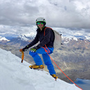
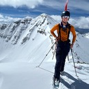
This trip has been on the mind in some way or another for several years. I first started considering the idea of a trip to Rainier about three years ago when Greg, one of my teammates on this trip and first ever 14er partner, suggested we make the trip up there in the summer and climb the standard DC route. At the time, I had a few other friends that had already tackled some glaciated peaks in the Cascades, and so I reached out to them for advice. The overwhelming response was that I was not in any way prepared to attempt Rainier unguided, which was harsh but very true advice. I didn’t have cold weather camping gear, I didn’t know much about technical ropework beyond basic sport climbing, and certainly didn’t know anything about haul systems or snow anchors. Needless to say the idea of Rainier was put on the backburner indefinitely.
In the mean time, I continued climbing 14ers, and began to expand my scope of knowledge beyond hiking, scrambling, and sport climbing. I began snow climbing couloirs, moved into pursuing more trad climbing than sport climbing, and worked hard for several seasons to develop myself as an ice climber. I spent several days out with IFMGA and AMGA guides working on leading ice and discussing tactics for pursuing big mountain objectives. I was also very fortunate to find myself in a budding partnership with another local ice climber that took me under his wing and provided invaluable mentorship for both ice climbing and climbing big mountain objectives over the course of the next few years. Along the way, my brother-in-law Nathan, my other teammate on this trip, moved to Colorado and quickly followed suite in training for technical big mountain objectives. Between my ice mentor Mike, my brother-in-law Nathan, and a few other key climbing partners such as my buddies Matt and Dustin, my tic-list of bigger objectives began to grow. I stepped away from bagging new Colorado 14ers, and instead focused on more technical climbs, such as the Grand Teton, The Sharkstooth, desert tower climbs, various steep snow climbs, and climbing water ice all across the state, getting comfortable leading up to WI3.
As I continued to gain a larger toolbox of technical climbing knowledge, my climbing partners and mentors began encouraging me to step a little further outside of my comfort zone, and make my way up to the Cascades. I think I still have a long way to go before calling myself an real alpinist or mountaineer, but as any good alpinist-in-training knows, spending time learning the intricacies of glacier travel and crevasse rescue is a vital part of an alpinist’s toolkit. Having several friends that have spent time on Hood, Rainier, Baker, and Shuksan, as well as glaciated peaks of South America, the consensus between them all was that with some additional formal training, tackling Rainier would not be a far stretch for me. My friends have climbed many of the major routes on Rainier, including the Ingraham Direct/DC, the Emmons-Winthrop, and the Kautz, and I was encouraged to pursue the Emmons-Winthrop as a route that would challenge me without getting too technical, and allow me to experience some level of navigating a glacier without the aid of hand lines and ladders that would be present on the Ingraham/DC.
At this time, Nathan also began looking to expand his horizons to the Cascades and was looking to build a team with me to pursue Rainier, especially since Denali is high on his list for future climbs, and he knows that he needs to get some experience in the Cascades as a pre-req. As Nathan had been my partner on many snow climbs, ice climbs, and big technical objectives, I knew immediately that we would fill 2/3 spots for our unguided team. We decided that we would only go if we had the additional safety of an third climber on the rope team and so we began putting our feelers to local climbing partners. One partner in particular was immediately interested and began rearranging his schedule and asking for time off to facilitate his presence on the trip. Of course, this was Greg, the first climbing partner of mine that ever suggested Rainier to me, a fitting moment as things came full circle back to my first ever 14er partner.
Soon enough we had a 17 page Google Doc filled out with all the logistics of the trip, permit reservations were acquired, multiple guidebooks were read and memorized, and we all took two separate classes on Glacier Travel and Crevasse Rescue including a day together with an AMGA Alpine Guide where we refined our skills before the final months of training. We also followed an 8 week Uphill Athlete Mountaineering workout plan, and started really focusing on getting into shape to help increase our chances of success.
The Start of the Trip
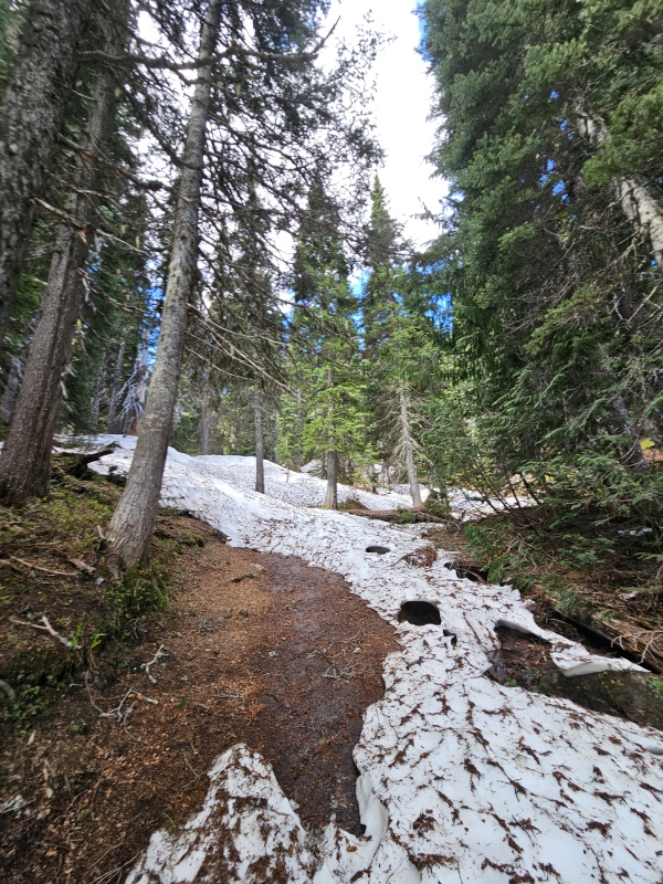
We had acquired permit reservations for Monday 6/12 through Friday 6/16 to sleep at Emmons Flats, an alpine camping site located on the Emmons Glacier just above Camp Schurman. The thought was that we would get enough nights to try and make our chances of finding a weather window to summit even greater, and we picked Emmons Flats instead of Camp Schurman only because Schurman was listed as Walk-Up only on those nights. When arriving at the Ranger Station to pick up our permits, the very kind and knowledgeable Park Ranger named Brady offered for us to swap our permits for Camp Schurman, of which we happily obliged since Camp Schurman has a bathroom. Having our actual permit in hand now, we set off from the Glacier Basin Campground and began our trek up through Glacier Basin towards the Inter Glacier, the small but sometimes formidable glacier that would stand between us and the top of Steamboat Prow and Camp Schurman located just underneath of Steamboat Prow.
Our first sight of Rainier and our route as we worked our way through the trees along the Glacier Basin TrailTrail conditions in the trees - some trail, many snow piles, and a few sketchy snow bridges over creeksContinuing our way up the BasinContinuing our way up the basinWorking our way out of the basin on a small dirt ridge
Before we knew it, we were arriving at the base of the Inter Glacier. Although there were many skiers that were booting up the Inter Glacier without roping up, we knew from assessing historic satellite data and reading TRs that the Inter Glacier does develop crevasses and that there is a risk of punching through a snow bridge. This early in the season the risk is much lower, which is why so many others were going up unroped, but we decided that there was no reason for us not to rope up. Not only is it safer, but we might as well use the safety gear we brought, and it would be one more opportunity for practice as a team of three before stepping foot onto the Emmons Glacier in the very near future. We stopped at a rock outcropping once on snow, donned harnesses, helmets, crampons, and our crevasse rescue kits, and roped up as planned, with Greg in the middle, and Nathan and I on the ends with the kiwi coils around our torsos.
Making our way up the Inter Glacier
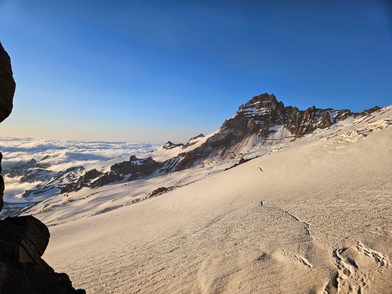
As we approached the ridge on lookers left near the top of Steamboat Prow, the Emmons Glacier began to tower over us, showing us what we had to look forward to in the morning.
On the ridge near Camp Curtis, Rainier and the glaciers dominating the landscape behind us
We quickly ditched the rope for the short rocky scramble down onto the Emmons Glacier below us, where we would rope up once again for the short jaunt around the tip of Steamboat Prow until we reached our campsite at Camp Schurman. We got a small taste of what the Emmons has to offer as we stepped over several open crevasses to get to Camp Schurman.
Roped up once again, making our way around to Camp SchurmanOne of the open crevasses on the approach to Camp Schurman
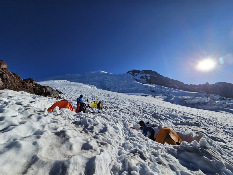
We arrived at Camp Schurman, chose our spots on the glacier just beside the rocky outcropping where the Ranger Station and bathroom are located, and pitched our tents near an RMI group that was already at Camp Schurman. At this time, we had knocked out roughly 5,000’ of vertical gain already. For this trip we had two tents, a 1p tent for Greg and a 2p tent for Nathan and I, both 4-season double walled mountaineering tents. These tents would prove invaluable later in the trip when gale force winds blew into camp, battering us for over 12 hours…
Nathan and I’s tent w/ a cloud inversion in the backgroundRanger Station at Camp SchurmanViews of Little Tahoma from Camp Schurman, as well as the crevasse activity on the lower Emmons guarding passage into CampOne more photo from our tent - the sunsets are magical up there!Another view of our location where we would be living on the glacier for a few days
We quickly began making dinner, melting snow to fill our bottles, and getting ready to get back up in just a few short hours for a 1am start for our summit push. Unfortunately I don’t think any of us slept that night due to the excitement of knowing our summit push would start soon, but as stated in one of the Rainier guidebooks we read by Mike Gauthier, we knew not to underestimate the value to laying down and trying to close our eyes for a few hours, even if we didn’t sleep. We would need all the rest we could get for the next ~5,000’ of vertical gain that would await us in the morning.
Summit Day
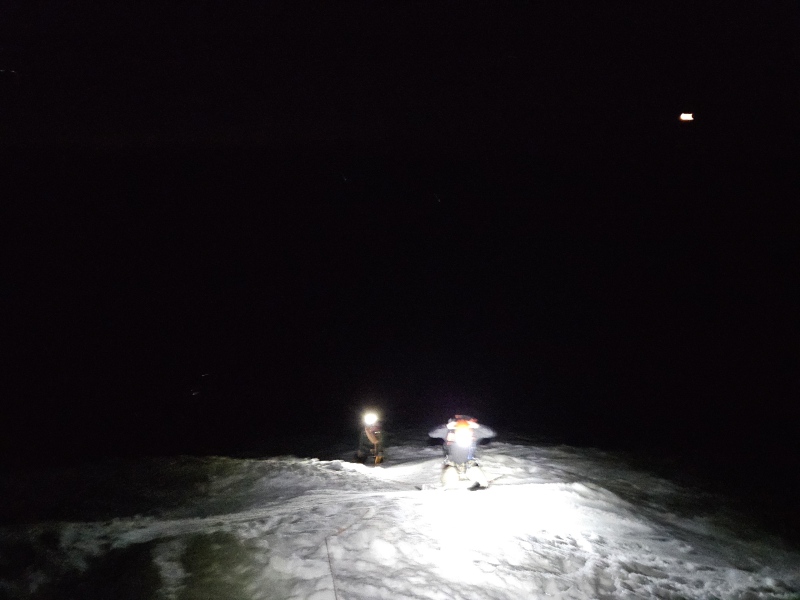
We all woke up between 11:30pm and midnight and worked to get some food and water in us before starting our summit push. Unfortunately I woke up terribly nauseated, and was only able to get a few granola bars in me, instead of the large breakfast I had planned. One thing I’ve learned from ultrarunning though is to take advantage of whatever calories you can stomach, even if it isn’t what you had planned. I followed up the granola bars with 500cc of water with LMNT mixed in, and felt myself gaining the energy needed to start the trek. We roped up and took off up the Emmons, following the “cattle tracks” of those that had climbed the route over the past few weeks with myself in the lead of our three person team. We left Camp Schurman at 1am, and were the first group to leave for a summit push that morning. Slowly but surely we watched the other groups come to life over the next few hours and start up behind us.
We don’t have many photos of our first few hours of the climb due to it being so dark, but here we are taking a short rest in the “Corridor”
It wasn’t long until the mountain reminded us that we needed to be on our A-game. As we passed above the area known as the Emmons Flats and entered the “Corridor”, I heard a yelp from Greg and a radio transmission from Nathan saying “Greg’s in a crevasse, drop into self arrest position while we figure this out”. I dropped down into self arrest position and looked behind me. I expected to see a frantic scene of our rope going deep into a crevasse with Nathan self-arresting and holding all of Greg’s weight. What I saw couldn’t have been more different, as Greg had punched through a small snowbridge but had not fallen all the way through, and instead was only up to his waist where his upper body had prevented him from falling through, and instead of a frantic scene, I heard Greg laughing and saying “Well ain’t this some shit. Give me 30 seconds and I’ll be out and on our way”. He planted his axe to his side, pulled his legs out, and took a look into the crevasse - “Man, this thing is about 30 feet deep… How cool is that!”. He then got up, we made sure Nathan crossed safely, and we began working our way up the Corridor once again. As one of the AMGA Alpine Guides that we trained with told us, most crevasse falls on the mountain are relatively simple and look quite like this one: a climber that punches though but easily steps right out without incident. Very rarely are big falls requiring partner rescue occurring, but having our first crevasse fall this early in our summit push was not reassuring. As the leader of the team, I knew that in many ways I would be the guinea pig as we continued navigating via headlamp, and that my navigation decisions would affect the safety of my team. As we continued climbing, I began to communicate with my team that I was getting a little nervous as the leader of the rope team for this reason, and felt responsible for Greg’s fall, but they both reassured me that there were no signs that there was a small snowbridge in that location that I had missed, and that they felt safe with the decisions I was making to navigate. I am very happy to report that this minor fall was the only incident we had during the whole trip, but still, I wish it hadn’t occurred.
Taking another break with dawn’s early light beginning to illuminate the horizon. Two other groups now visible behind us as we continued up the mountain
We continued to work our way up the mountain, and knew that the “crux” of the route at this time would be a large bergschrund located around 12,300’ as reported to us by other climbing groups as well as the climbing rangers at Camp Schurman. We were told there were two options to get around the bergschrund: Stay left and navigate a possibly convoluted labyrinth of crevasses, or end run the bergschrund to the right and attempt to cross one of the few remaining snow bridges that were predicted to collapse within the next few days. At this point, we had reached an elevation where the snow felt super bulletproof and hard, even front pointing our crampons a few times on some of the steeper sections. We decided to end run the bergschrund to lookers right and see if the snowbridges were an option. What we found were some very thin looking snowbridges with cracks running across them, but felt that a very wide step would avoid the thinnest section in the middle. We kept our rope taught as we each crossed with someone in self arrest position at all times to help protect the move. We considered placing some running protection, but ultimately decided that with the freezing conditions, the bridge was as solid it would be all day. We sent Nathan across first (the lightest in the group), followed by Greg, followed by myself. Now Nathan would be in the lead until the summit. We crossed the bergschrund without any issues, and continued up as high as we could before the cattle tracks turned to the right again to traverse under a large serac and cross a huge snowbridge over a crevasse that was easily 10-20’ wide in places.
Continuing our way up after crossing the bergschrund at 12,300', the sunrise finally poking it's head above the surrounding mountainsView of Little Tahoma and crevasse/icefall activity alongside the route on the way upWhere the route turns to the right to avoid a large crevasse blocking passage to the summit. An RMI group was quickly catching up to us, and is seen here taking a break before traversing underneath the large seracTraversing under a ~30’ tall serac surrounded by icefall while making our way to a large snowbridge to gain the saddle
After crossing a large snowbridge across what appeared to be an impossibly wide and deep crevasse, we gained the saddle and started working our way up the final 800’ of vertical gain to the crater rim and Columbia Crest. We stopped for a long rest on the saddle to hydrate and fuel up, and then took off for the crater rim. This was now our second day in a row with ~5,000’ of vertical gain, and we were moving slow at this point. The RMI group passed us just a few hundred feet below the crater rim and beat us to the summit by just a few minutes. Upon reaching the summit, we unroped and took shelter from the high winds just inside the crater rim, and took a few minutes to melt some more snow with our jetboil to refill some of our bottles. After doing so, we donned a few more layers as the winds continued to pick up, snapped some photos, and scurried back down the backside of the crater rim where we roped up for the descent and began working our way back down the mountain.
Myself on the crater rimThe whole teamGreg’s solo shotHow Greg was actually feeling…Nathan’s solo shotHanging out just inside the crater to shield ourselves from the wind
The descent was very straightforward. At this point we knew the route, and had become much more comfortable with the hazards of the mountain over the last few hours. Now that the sun was up, it was much easier to identify where possible hazards were on the mountain. Crevasses that were open along the sides of the route could be mentally traced to where we would be crossing them over snowbridges, and we became much more aware of the subtle differences that could be noticed in the snow that might indicate a possible hidden crevasse, such as streaks of snow that appeared to have a different texture than the surrounding snowpack, or even streaks of discoloration. We moved down very quickly, and descended in less than half the time it took us to reach the summit. Very few photos were taken as we had known for days that a bad wind storm would be blowing in that afternoon, and we did not want to get caught on the upper glaciers when it hit.
We reached the bergschrund at 12,300’ and crossed in the same location we had before without any issue. We quickly worked our way back to the top of the “corridor” and then back down the “corridor” as well. By the time we were approaching Camp Schurman, the snow was starting to soften from the midday sun, but we knew that we were back in a relative area of safety and the reality of having summitted the mountain began to sink in.
The snowbridges on the descent after end-running the large bergschrund at 12,300’. We were one of several parties to cross here that day.
We arrived back in Camp Schurman just as clouds began to envelope the upper mountain and the winds began to gust. Soon enough the winds were so strong that they were pushing me over everytime I went to walk outside of the snow pit where our tent was located. We cooked in the vestibule of the tent, ate a quick dinner, and soon took shelter inside our tents while the reported 85 MPH wind gusts battered our campsite. Despite the winds, we were so exhausted and slept late into the next morning.
The “Premium” spot weather report via my Garmin InReach and their partnership with Dark Sky. Those 85 MPH wind gusts tried really hard to destroy our tent, but we managed to stake it well enough that it remained grounded and secure.Shortly after returning to camp, with the clouds enveloping the upper mountainNathan stayed wrapped up in his mummy style bag like this for over 12 hours while temps dropped and our campsite was battered with high winds
The Final Day
The next morning we welcomed some new climbing teams to Camp Schurman, shared our beta, and began our descent back to the trailhead. We roped up for the short walk off the Emmons glacier back to the rocky scramble to regain the ridge of Steamboat Prow. Once back on the Inter Glacier, we roped up for the descent again until we hit the lowest sections of snow. We unroped, had a short glissade, and quickly made our way back to the dirt trail back in Glacier Basin. Once back on the trail, the miles began to melt away as we worked our way back to the trailhead. Soon enough we were back at the car, just over 50 hours since leaving, with a successful summit of Rainier now under our belts.
Roped up while exiting Camp Schurman and making the short walk back to the rocky scramble to regain the ridge of Steamboat Prow
Final Thoughts
This trip was the result of an entire year of planning and training, and overall I felt like we prepared about as well as we could have without making other trips to the PNW to climb other Cascade volcanoes first. We felt comfortable with our gear, felt comfortable with self-rescue and haul systems, and conditioned ourselves well. I think there would definitely have been value to climbing other peaks in the Cascades first, but I don’t necessarily think that it’s an absolute prerequisite. I recognize that I was very lucky to have the advice, guidance, and training from experienced mentors and certified mountain guides over the year I spent planning and training for this objective. Does all this make me qualified? Maybe, maybe not. I think it can be an impossible question to answer, but I do think our preparation was largely adequate. I feel like I left with an immense feeling of satisfaction from reaching the summit unguided, but also with a ton of lessons learned, such as learning how to better recognize hazards on glaciated terrain, and many learning points about living on a glacier. One example of a big learning point for us, was that our method for melting snow was terribly inefficient, and that a jetboil does not suffice for melting snow for a group of three. It uses a ton of fuel, and doesn’t melt very much at one time, making it very difficult to refill bottles and cook meals. We also learned from the other groups at Schurman about how to be creative in staking a tent to withstand a windstorm, such as using axes, snow pickets, and more to ensure the wind doesn’t take it away. We also gained practice in building snow walls to protect our campsite and other creative ways to endure a storm in that terrain. Lastly, we gained a powerful reminder that the success of one is dependent on the success of the team when on a glacier. You move together, you rest together, and you continually check in with each other as everyone’s safety is dependent on the practices of the rest of the team.
To celebrate and get in some active recovery, we explored the Olympic Peninsula for a few days after leaving Mount Rainier National Park. I highly recommend checking it out if you head up to the Seattle area. We visited rainforests and the Olympic National Park coastline. A few pictures are below. Thanks for reading this trip report to this point. I will probably update it a few times as I think about more details to add. Let me know if you have any questions.
Waterfall in the Quinalt Rain ForestExploring the rocks along Beach 4 in Olympic National ParkPlenty of mossy trees to be found on the peninsula if that’s your thing…
Thanks for reading!
Thumbnails for uploaded photos (click to open slideshow):
On one of Americas finest peaks! I climbed Point Success via Kautz Ice Chute a couple years back but got stormed off the summit so I need to go back. The Emmons-Winthrop Glacier has my attention for a round 2 with Rainier, how do you think it would be as a ski?
Congrats again, any trip to the PNW is memorable, but the Cascades are just the best!
There were quite a few skiiers up there, and I think the Emmons is quickly becoming the most popular ski descent route. It certainly isn't something I would personally do, but if you have the skills, I think a late May / early June ski descent would be pretty reasonable!
Hey Eric, Must've seen you guys up there at some point! I was in a group of 2 who went for the summit on Rainier for a one day push that day summiting around 11:30!
Good to see other Coloradoans out there! Good work!
Thanks Declan! Did you summit via the Emmons as well? Must have passed right by you! We summited just before 9am and then started descending by 9:30am.
Congrats on your summit as well! It's one hell of a mountain.
Congratulations. I'm doing this in two weeks. Have a few questions.
1) Do you have full times you can share for each day?
2) How long were you able to hike without needing to put on your mountaineering boots?
3) Related, would you do that again? Was it worth carrying the weight of the boots for that distance?
1) So I just looked through my Coros data, and I'm having a little trouble interpreting the specifics of my recording, but it roughly follows as such:
~6 hours from TH to Camp Schurman
~8 hours from Camp Schurman to Summit (although we didn't get any sleep at Schurman that night, so we started out really slow for the first few hours - the RMI group behind us did this in about 6 hours)
~4 hours from Summit back to Camp Schurman
~4 hours from Camp Schurman back to TH
2) Nathan and I both started with mountaineering boots at the TH, which I think was the way to go. Greg wore sneakers until just before Glacier Basin Campground and then changed into his boots, but also had to walk over countless snow piles blocking the trail and got his socks wet in the process, so IMO, I don't think it's really worth it. With that said, the snow on the trail is melting quick, so in two weeks you may be able to get a little further before donning your boots.
3) I definitely would do it the same way again. That is, starting with my boots on at the TH and not bringing another pair of shoes.
Good luck! Are you going via the Emmons? If going via the DC, the approach trail will be different than this one.
I'll add to Eric's response, from a different party that did this a few years back, same route, same time of the year (June 21-24, 2019).
1. We split it up with an evening hike to Glacier Basin, then a short day up to Camp Schurman, then a summit day (camped at Schurman after summiting), then back down. About 2 hours to Glacier Basin, another 4.5 hours up to Camp Schurman. Summit day was about six hours up, four hours down. That's a relatively fast pace, mostly attributable to living at altitude. We descended the remainder the following day, about 3 hours with a glissade down Inter Glacier. A good approximation of summit day is a ski / board day on Shavano from the summer trailhead, in terms of vertical, actual elevation, and weight carried.
2. Mountaineering boots all the way, I'd just stick with one pair.
Congrats on this summit! I hiked St. Helens the next day, the Cascades really are a whole different ball game. From the pictures it looks like you wore Nepals? Was a single boot warm enough or did you ever develop cold feet? Ive read most people recommend wearing doubles if the freezing level is below 10,000 which I assume it was for mid-June.
Yep I wore LS Nepal EVOs, and Nathan wore the similar LS Nepal Cubes. We both had no issues with cold feet. As cold as it got, it still wasn't near as bad as the conditions I'm used to ice climbing here in CO all winter, which I also only wear singles for. Of course your milage may vary though, as many folks do wear double boots up there this time of year and claim that singles wouldn't be warm enough for them.
Nothing we experienced was near as cold as standing around for hours in RMNP giving a belay in the middle of winter haha. Maybe that just has me conditioned to cold temps and high winds though.
- Eric
Caution: The information contained in this report may not be accurate and should not be the only resource used in preparation for your climb. Failure to have the necessary experience, physical conditioning, supplies or equipment can result in injury or death. 14ers.com and the author(s) of this report provide no warranties, either express or implied, that the information provided is accurate or reliable. By using the information provided, you agree to indemnify and hold harmless 14ers.com and the report author(s) with respect to any claims and demands against them, including any attorney fees and expenses. Please read the 14ers.com Safety and Disclaimer pages for more information.
Please respect private property: 14ers.com supports the rights of private landowners to determine how and by whom their land will be used. In Colorado, it is your responsibility to determine if land is private and to obtain the appropriate permission before entering the property.


")
")
")
")
")
")
")
")
")
")
")
")
")
")
")
")
")
")
")
")
")
")
")
")
")
")
")
")
")
")
")
")
")
")
")
")