| Report Type | Full |
| Peak(s) |
Missouri Mountain - 14,071 feet Mt. Belford - 14,202 feet Mt. Oxford - 14,158 feet |
| Date Posted | 08/07/2023 |
| Date Climbed | 08/06/2023 |
| Author | smfgoal |
| Missouri Mountain Triple Link-up via East Ridge |
|---|
|
As I approached Missouri Mountain at 7 am, I wondered if the Belford-Oxford duo could be linked though the ridge on the far side of the summit. After asking around and getting mostly “you’re insane if you attempt that” we decided to give it a shot anyways. Two dudes at the top dressed in Solomon hats and Melly socks asked me to write a trip report on the traverse, so this one’s for them: Saturday night I received an invitation to come climb Missouri, Oxford and Belford, and having 0 peaks bagged in two years I couldn’t refuse. With a minimal glance at 14ers.com and some previous experience from my friends we set off around 5:45. The goal was to summit Missouri first, then drop back into the valley and climb back up to Belford to transfer to Oxford. After gaining the peak of Missouri, my legs were already a little tired. Suddenly the idea of dropping back down to climb back up seemed a little tedious. I had saw posts about skirting all the technical terrain to get to Elkridge saddle, but my group of friends were not about to escape without some fun. Word of warning, the four of us experienced rock climbers and 2 (including me) of the 4 have experience in technical alpine terrain. That being said, even some of the more technical moves got my stomach turning. The Missouri mountain cliffs are impossible to see their true size until you are standing on top of them. Looking at it from the basin floor doesn’t do them justice. They are a ridge of rotten rock that cliff out often and quickly, with 200-700 foot cliffs on both sides. The north face obscures the larger cliffs on the south face, which cannot be seen from the basin. I believed there was a way around using the south face, as the north face looked like a pile of very loose dirt. The south face at least had the option of bailing into the slightly more solid scree field. Beginning at the top of Missouri, me and my group of 3 walked down towards the edge. We were able to take the right side of the first two piles of rock, until we got to the third, which from some prior examination, we believed to be the crux. 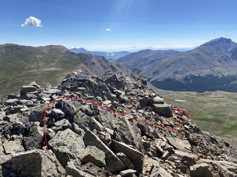
 Standing on top of a 5x5 block, I looked out towards Belford. To my left was extreme exposure, where there was no path down. To my right was a steep slab of solid rock that dropped onto a shelf. After making some easy 3 class moves we all made it to the shelf. (Some may consider this 4th class if you take into consideration the steep hill that existed past over the shelf. A fall here would possibly be fatal.)
From there we continued along a second class ridge until we encountered the actual cliff band. The shelf became narrow and rotted out. Our path became steep. To be able to continue, we must downclimb 30 feet. The first 20 feet I would consider class 3 on okay rock. However, the last 10 feet involves vertical class-5-esque moves. However, it’s only 2-3 moves with a long fall zone before it cliffs out (50 feet of scree), so I’d call it like a moderate class 4. Still, falling would involve a pretty rough roll down into the gully (which might be enough to kill you), but there is little exposure to the cliff face in the section of gully that you traverse.
After crossing the gully and climbing up between a notch, we were faced with another gully, this time with some exposure to the face. The ground here is loose and soft, and a fall here would send you over the edge, and most likely to your death. Although the moves here are easy, the exposure is too much to downplay it. Class 4
After crossing the second gully, you are faced with the hardest section. 50 feet of low 5th to extreme 4th class climbing. The gully will naturally force you onto a block just big enough for two people to stand on, but be wary of the rotting rock that defines this area of the cliff. A 300-500 foot cliff to the right and rear began to make me feel uneasy. I looked down upon the near vertical face and began to question our route. A steep corner is the main feature of this section. My guess is that the grade here could be pushing into 5.5 to 5.7 territory, but there was really no way to tell for sure. A fall in this section would begin with free-falling down the rest of the vertical face onto steep scree and loose dirt, likely causing you to slide down the remaining 3rd class choss onto a small pass. This would most definitely be fatal. There is no room for error on this section, and attempting this without previous experience is almost a death wish. As the rest ledges on this section are small, only a few people can stand on each ledge, so our progress slowed down considerably.
(Harder variation of the crux. Look down and to the right for and easier slab section.) While I waited for the rest of my group to prepare, I attempted to clean the top of the downclimb. I was dislodging 10-300 pound blocks from the wall with a slight wiggle or kick. I began to worry, as the rock was so bad I felt a fall caused by a broken hold could easily kill a person below. I had to keep looking for other options. I glanced down and to my right - a very exposed block large enough for one person is 7 feet below the block that I was currently on. I would have to backtrack a slight bit, so I asked my buddy to take over the routefinding. With a slight scooch down to solid footing, you can grab the knife edge on the south face. From there, traverse the edge Capitol Peak style until you reach a horizontal crack for you feet. Downclimb slightly and continue left back towards the main ridge. You will then turn back around and walk out right under a small steep outcropping. From there, encounter a small cut in the rock and scramble down. Descend the rest of the scree field and from then you are home free.
Follow the game trail back up and over onto Elkhead Pass and either descend back to the trailhead or push for Belford and Oxford. We ended up completing all three peaks, even if it was a super long day. In the end, please do not attempt this route if you don't want to end up possibly hurt or killed. From my understanding and some research, this ridge is the center of many SAR operations rescuing people doing something similar. Rockfall potential and exposure is EXTREME here, and if you aren't comfortable with either of those things, save your life and go back down the way you came up. Thumbnails for uploaded photos (click to open slideshow): ")
")
")
")
")
")
")
")
")
")
|
| Comments or Questions |
|---|
|
|
Caution: The information contained in this report may not be accurate and should not be the only resource used in preparation for your climb. Failure to have the necessary experience, physical conditioning, supplies or equipment can result in injury or death. 14ers.com and the author(s) of this report provide no warranties, either express or implied, that the information provided is accurate or reliable. By using the information provided, you agree to indemnify and hold harmless 14ers.com and the report author(s) with respect to any claims and demands against them, including any attorney fees and expenses. Please read the 14ers.com Safety and Disclaimer pages for more information.
Please respect private property: 14ers.com supports the rights of private landowners to determine how and by whom their land will be used. In Colorado, it is your responsibility to determine if land is private and to obtain the appropriate permission before entering the property.


