Download Agreement, Release, and Acknowledgement of Risk:
You (the person requesting this file download) fully understand mountain climbing ("Activity") involves risks and dangers of serious bodily injury, including permanent disability, paralysis, and death ("Risks") and you fully accept and assume all such risks and all responsibility for losses, costs, and damages you incur as a result of your participation in this Activity.
You acknowledge that information in the file you have chosen to download may not be accurate and may contain errors. You agree to assume all risks when using this information and agree to release and discharge 14ers.com, 14ers Inc. and the author(s) of such information (collectively, the "Released Parties").
You hereby discharge the Released Parties from all damages, actions, claims and liabilities of any nature, specifically including, but not limited to, damages, actions, claims and liabilities arising from or related to the negligence of the Released Parties. You further agree to indemnify, hold harmless and defend 14ers.com, 14ers Inc. and each of the other Released Parties from and against any loss, damage, liability and expense, including costs and attorney fees, incurred by 14ers.com, 14ers Inc. or any of the other Released Parties as a result of you using information provided on the 14ers.com or 14ers Inc. websites.
You have read this agreement, fully understand its terms and intend it to be a complete and unconditional release of all liability to the greatest extent allowed by law and agree that if any portion of this agreement is held to be invalid the balance, notwithstanding, shall continue in full force and effect.
By clicking "OK" you agree to these terms. If you DO NOT agree, click "Cancel"...
Velocity Basin is a terrific and beautiful place. I know that’s somewhat par for the course for the Silverton area, but considering I’m in Silverton frequently, I was still blown away by the secretive, almost penned in beauty of this basin. Our plans were to scale “East Storm,” Tower and perhaps Dome Mountain if the dog was having it. But as it turned out, the weather only granted us one. But at least the road up Cement Creek (into Velocity Basin) is ‘Subaruable.’
Typically any named summit that includes a directional term (southeast, north, Kanye West etc.) is named thus in associated to a higher if not more prominent neighbor. In this case, Storm Peak lends it’s notoriety to its slightly lower brethren. “East Storm”(unofficial name indicated by the quotation marks), was actually once known as Velocity Peak taking this name of course, from the namesake basin. And speaking of which, Velocity wasn’t bestowed upon this alpine valley until the early 1980’s when the downhill speed skiing championships came calling. Before this, the valley was referred to as 'Colorado Basin.' Which kind of begs the question, with Storm Peak being more prominent and higher, why didn’t IT adopt this moniker? That’s because Storm Peak has been known as thus since 1906. I’m guessing, because it has a penchant for unruly weather.
There is a class-2 route up “East Storm” that ascends fromBoulder Gulch. The entrance is near the tailing ponds at the Mayflower Mill up San Juan County Road #2 (towards Animas Forks) at 9,700’. This trail is also very popular with downhill mountain bikers, so take heed. The Velocity approach from Glacier Lake (unofficial name) starts you off at 11,300’. This is why we opted for this approach despite the class-3 variation.
The trail leaves Glacier Lake going straight east and wastes no time in gaining elevation. It’s a class-1 trail but it’s a steep bugger. Thankfully, we had NO mosquitoes to deal with; small mercies, right? We were also fortunate in that, we followed a couple of downhill mountain bikers carrying their bikes up the trail. Mountain biking on this portion of the trail is not permitted. Not that actually following other people is a grace, but these peeps knew a short cut that didn’t involve going around a massive west shoulder. By following them, we shaved off almost 2.5 miles. I’m not normally receptive to trail cutting but every once in a while, it makes sense to do so.
We sped across the mellow ridge higher & higher to a nexus at 13,060’ that had a stone memorializing someone’s beloved who had passed. From this grassy perch, Tower Mountain, Dome Mountain and MacComber lay off to the left. “East Storm” of course, was to our right. The views were quite impressive. And considering I’m hoping to ski Silverton Mountain next winter, it was VERY beneficial to see the eastern aspects and gullies without the concealment of snow.
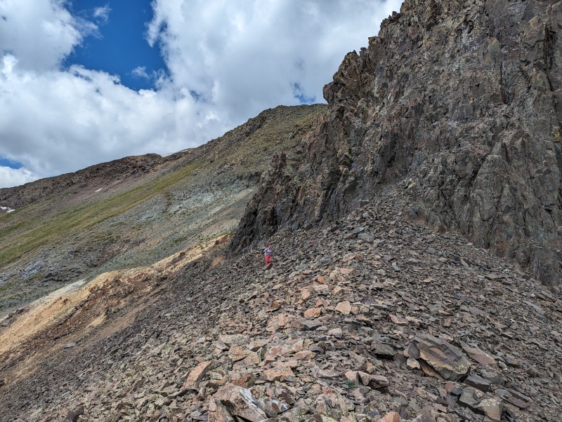
From the grassy knoll, it was another .4 mile on class-2 terrain before difficulties came into play. There is a short section under some crags and cliffs where there is some easy talus traversing but nothing too hard. Weirdly, right before all the loose talus, I came across an 8’ bamboo pole, definitely one of the more random things I’ve come across. So I picked it up, put away my regular pole and used the staff instead. Due to its height and the looseness of the slope, it actually came in great use!
The goal was to regain the ridge. But in order to do so, we had to ascend some stupefyingly loose, borderline 3rd class ledges & slope. The ledges weren’t so much ledges as they were footholds. A slide or fall on this slope wouldn’t end with disastrous results, but you’d probably look like you came out on the losing end of a fight with a Brillo pad.
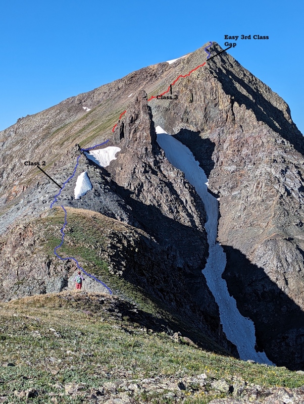
Once we were on the ridge, the difficulties eased (as they usually do) for another .2 mile until we came to a 3rd class notch. We ascended by going left and descended by going left. Both sides work but the exposure is pretty good. After navigating this notch, the remainder of the ridge goes at class-2 until the summit.
Consensus….
Even though Boulder Gulch offers a more established route with an overall easier ascent and easier to get to trailhead, I believe Velocity is a better choice despite the 3rd class stuff one has to negotiate. You start 1,600’ higher for one. And there are more choices that, once on the upper ridge, if the weather starts to get frisky, there are easier, class-2 cruiser objectives one can do, which is what we did the very next week by going back for Tower & MacComber Peak.
A look up at the route
My GPS Tracks on Google Maps (made from a .GPX file upload):
Caution: The information contained in this report may not be accurate and should not be the only resource used in preparation for your climb. Failure to have the necessary experience, physical conditioning, supplies or equipment can result in injury or death. 14ers.com and the author(s) of this report provide no warranties, either express or implied, that the information provided is accurate or reliable. By using the information provided, you agree to indemnify and hold harmless 14ers.com and the report author(s) with respect to any claims and demands against them, including any attorney fees and expenses. Please read the 14ers.com Safety and Disclaimer pages for more information.
Please respect private property: 14ers.com supports the rights of private landowners to determine how and by whom their land will be used. In Colorado, it is your responsibility to determine if land is private and to obtain the appropriate permission before entering the property.


")
")
")
")
")
")
")
")
")
")
")
")
")
")
")
")
")
")
")