| Report Type | Full |
| Peak(s) |
Capitol Peak - 14,138 feet |
| Date Posted | 08/31/2023 |
| Date Climbed | 08/30/2023 |
| Author | jmfb3 |
| Ups and Downs and a Deadlamp |
|---|
|
What an adventure. What a great climb. The only things that seemed to not cause me headaches were the knife edge and the route-finding after k2.
Constant Issues A number of obstacles prevented me from starting my backpack in until 6:55PM (plan was 3:30PM). Amongst work issues that delayed hours, and a forgotten camp stove that required unexpected stops on the road, this also included getting to the trailhead at 6:15, but coming across a couple climbers just returning whose two other partners had taken the car back down to the 2wd trailhead. I ended up driving them down there. I really started hustling when I finally got started - I got to the first junction at 1.2 miles in just 17 mins. As the uphill started to burn I realized there was no way in hell I'd make it to camp before dark, so I slowed down and accepted that I'd be hiking in the dark and getting very little sleep. It got dark shortly after linking back with the Capitol Creek trail. I got my headlamp out. Low battery. No spares. Rookie mistake. Given it was a class 1 trail, it wasn't much of a problem, just a little stressful / scary. But it got very stressful around 10,650 feet where the trail criss-crosses with the stone-walled gully. With my dim lighting I wasn't able to located the two sections where the dirt trail resumes and crosses the gully. Without any sign of the trail splitting off or even leaving the gully, I naively continued directly up the gully. I went up a few hundred feet and realized "this absolutely cannot be right". Off trail, in the dark, unsure where I lost it, I became very concerned. Fortunately I did have the map downloaded and I was able to backtrack and link back up. Beta for those who end up like me: Just after a group of ~5 small pines in the middle of the stones, the dirt trail resumes up to the left. Follow it, and you will come across a few large stone steps. Cross over the gully to find a rocky trail. The rocky trail becomes a sort of patio, at which point the dirt trail resumes off to the right back into the woods. (in the dark) It can appear that the rocky trail veers back left into the stone gully. It does not -_-. See photos below for reference (taken on hike out). 
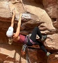
I finally made it to camp around 10pm, scarfed down dinner, and managed to get about 2 hours of sleep (I can't ever sleep backpacking for some reason). My plan was to begin hiking at 3:30 AM, but I knew this would be a bad idea with my dead headlamp (deadlamp). So I began my ascent from the lake at 430AM instead, hoping that when I reached the ridge the sun would start providing some light. I missed the very first turn and ended up at the lake (I began getting very frustrated). I came back and located the left I had missed. I thought maybe this would be helpful for sunlight. No such luck. I reached the ridge in pitch blackness, so I stopped and decided I was best off waiting a bit for sunlight. Then I saw a headlamp ahead of me and thought I'd just be able to follow that hiker. And a trail runner came up behind me a moment later with a headlamp bright enough to light the forest. I tried following them for a bit, but man those runners move quickly. Didn't matter though, once I had descended the second gully following the runner, the trail became very obvious. Beta: From the ridge, follow the dirt trail across one gully. The route description says "try not to lose too much elevation" here, but I think this is a bit misleading. The dirt trail descends quite a bit into the second gully, and you should follow it all the way down to where you can get around the gully wall without climbing it (or climb it ~20 feet above that which is what I did). From here the trail becomes easy to follow. K2 eventually appears up to your right. I went over K2 on the hike in and around on the way out. If I were to do it again I would probably go around both ways. I found the angled rock on the descent of K2 to be the sketchiest moves I made all day. And the climb around on the way out felt mild (but maybe that was just because my nerves were better off at this point). The Fun Stuff From K2 to summit took about an hour. I really really enjoyed the constant class 3/4 moves and the exposure. Ironically, I found the route finding here to be a lot easier than expected. Not that I didn't stop a few times, get mildly confused, and check the photos a lot, but I never really felt overwhelmed by the route finding after the knife edge. I had a much worse time in the dark on the class 1 trail haha. The exposure is real! But if you like that stuff you're going to have a really great time. The movement is really fun too. And that was it! Summited at 8am, returned without issue. Back to camp around 1130, back to car at 2:15. I have really bad knees, so you can probably make this return more quickly than that. One last piece of beta: on the way back to the Daly/Capitol ridge I did get concerned that I was descending too far. That was not the case - it is hard to see the ridge until you get pretty close to it, so don't be afraid to follow the cairns quite low (or at least much lower than your gut might tell you). Thumbnails for uploaded photos (click to open slideshow): ")
")
")
|
| Comments or Questions | |||
|---|---|---|---|
|
Caution: The information contained in this report may not be accurate and should not be the only resource used in preparation for your climb. Failure to have the necessary experience, physical conditioning, supplies or equipment can result in injury or death. 14ers.com and the author(s) of this report provide no warranties, either express or implied, that the information provided is accurate or reliable. By using the information provided, you agree to indemnify and hold harmless 14ers.com and the report author(s) with respect to any claims and demands against them, including any attorney fees and expenses. Please read the 14ers.com Safety and Disclaimer pages for more information.
Please respect private property: 14ers.com supports the rights of private landowners to determine how and by whom their land will be used. In Colorado, it is your responsibility to determine if land is private and to obtain the appropriate permission before entering the property.