| Report Type | Full |
| Peak(s) |
Meeker Ridge - 13,861 feet Mt. Meeker - 13,916 feet |
| Date Posted | 10/26/2023 |
| Modified | 11/14/2023 |
| Date Climbed | 10/21/2023 |
| Author | bangerth |
| Additional Members | bmcqueen |
| What is up with the northeast ridge | ||||||
|---|---|---|---|---|---|---|
|
When you drive up and down I-25 between Denver and Fort Collins, the climber's neck pretty automatically cranes over to see Longs Peak, the beacon of the northern plains of Colorado in the same way as Pikes Peak is in the south. Except, what one really sees is, for the most part, Mount Meeker -- from the Denver area, all you see is Mount Meeker except for Longs summit block peeking out from behind. And what you see is Meeker's broad eastern face: A nice, pyramidal shape with straight, long ridges that meet at the summit of the eastern sub-summit ("Meeker Ridge"), forming a triangle that is split right down the middle by Cabin Creek. I tried to find a good picture of this in my archives, but the only thing I could find that shows this in some reasonable detail is a cell phone picture taken from the west side of Loveland -- poor resolution, but perhaps you get the idea. 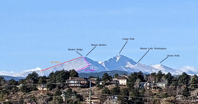
Later edit: A few weeks later, I ended up riding on the road from Estes Park to Lyons. There is the Saint Malo chapel, and that's where one has clearly the best view of all of this: 
I had climbed Mount Meeker for the first time in 2020, starting at the Sandbeech Lake trailhead, coming up the south slopes and southwest ridge, and then descending the frequently taken southeast ridge -- the left side of the triangle if you look at it from the plains. It's a long route, with an interminable way back down the mountain, but the ascent is great, and so of course is the connecting ridge between the two summits. Ever since I had been up there, I wondered every time I saw the mountain on a drive or bike ride what the heck is going on with the northeast ridge (the right side of the triangle). Does it go? I know that high on that ridge, the Iron Gates route comes out that many take from close to Chasm Lake, so at least the top part must go. How about the bottom? Searching the internet does not provide with any insight: Nobody seems to have written about it; so, few have likely taken it, and that means that few likely take it. I guess that means there's really only one way to find out: Explore! I talked Brad into trying, on 36-hour short notice. He was up for it. The hike starts at the end of the short 113N road, which leaves opposite of the Meeker Park Lodge. We knew that there is no trail pretty much straight away, once you leave the Horsetooth Mountain Trail immediately before it crosses Horsetooth Creek, and were mentally prepared for a good long bushwhack all the way to treeline. But it turns out that for surprisingly long, there actually is at least some kind of social trail. Why it exists was a bit of a mystery to us because it doesn't specifically go anywhere. It ends at the point where one crosses Cabin Creek, where there is a little log bridge and an enormous cairn. It's kind of an odd end point, but we were not about to complain about it either. From there, the bushwhack begins uphill, to gain the ridge. It is not terrible: As opposed to the other side of the valley, there is minimal deadfall, and so it really just comes down to dodging branches. There is little to say about that part of the hike; it goes on for a good long while, but we reached treeline at around 7:30am after having started at 4:40am. At that point, you are in an area where a number of rock towers dot the ridge: 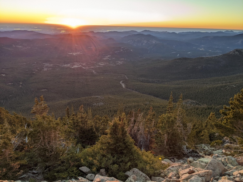


The lower part of the ridge has few technical difficulties. It is, however, quite a long way to the top: Once out of the forest, you stay on talus for the next 3000 feet of elevation gain. Things get gradually steeper, but most of it is class 2, with the occasional class 2+ or 3 towers, but nothing ever gets difficult. This is how it looks: 

Eventually, though, one comes to a place where first Mount Lady Washington, and then Longs Peak come into view, and they do look very good from this angle! Like this good: 

Up to this point, we hadn't seen a sign of human presence in several hours. There had been no cairn since we crossed Cabin Creek, not even a lost granola bar wrapper. This isn't a route frequently taken, perhaps unjustly so: It isn't difficult, it's just not described anywhere. (And perhaps it also comes out at the wrong mountain: Most people want to climb the higher Mount Meeker, but this route ends in Meeker Ridge, and getting from one to the other is of course of an entirely different difficulty than the hike so far.) But eventually, one meets up with where the Iron Gates route brings people up from Chasm Lake, and that's where we found a cairn again (along with the only other person whose path we would cross until close to the trailhead again). From there, a substantial stretch still remains to get to the top, but an end is in sight. Eventually, one simply tops out on Meeker Ridge, and that's that part of the hike: The northeast ridge goes, is never particularly difficult nor involves a substantial bushwhack, and provides great views. If you're interested in exploring uncommon routes, this is one that's worth it. Of course, once you're on top, you eventually have to start thinking about where to go from there. At Meeker ridge, you have two options for descent. The ridge we just came up on: 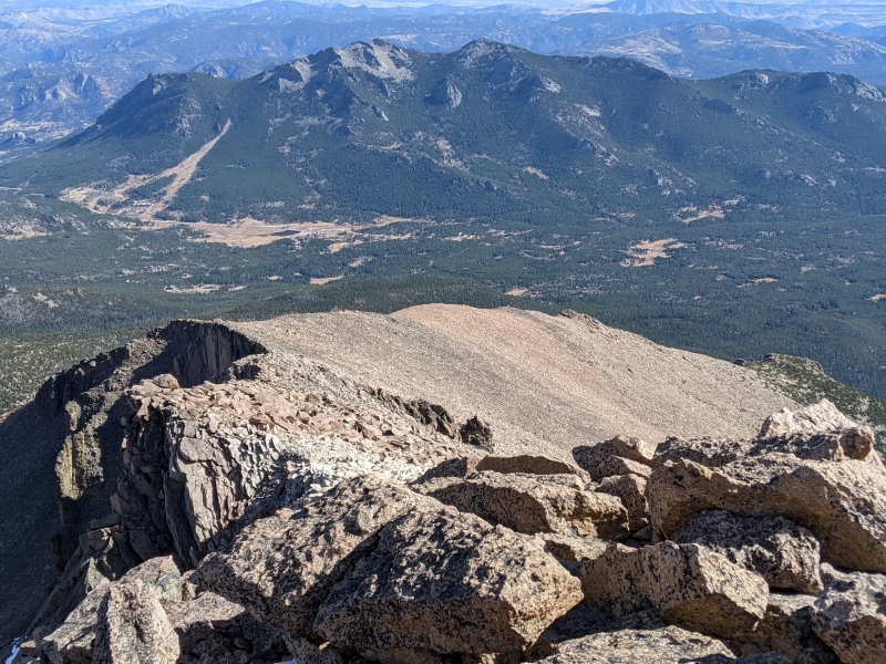
And then there's also the southeast ridge that we wanted to descend, and that's most people's first choice: 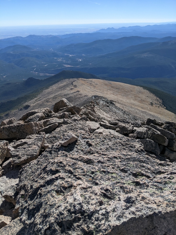
It looks fairly benign, but the perspective is a bit deceiving: The top part consists of rocky towers that require steep talus for quite a long distance until you finally end up on that shallower, grassy area. From there, one reaches the forest by dropping down another steep talus slope, before getting into the forest and ultimately back onto a hiking trail. Nothing of that is great; it's 5000 feet of elevation drop, it's hard on this old man's knees, and it takes forever. So why not postpone this for a bit and first hop over to Mount Meeker proper? Great idea, if you ask me. There's a lovely knife edge, certainly going at class 4, to cross first: 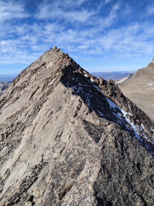
Once on the other side, the question is how to get back. One could cross the ridge a second time and then descend the southeast ridge, but a perhaps simpler way that avoids the difficulties of the knife edge as well as the initial towers on the SE ridge is to drop down on the south side of Mount Meeker just before the start of the knife edge, and to do a descending traverse below: 
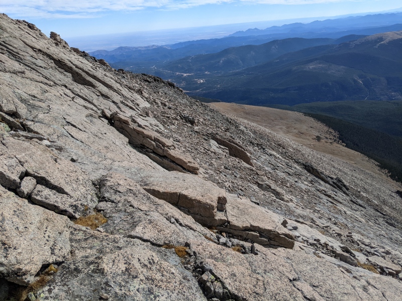
The way we went was never difficult, but it required a small amount of route finding given that the slabs just below the summits and the knife edge are generally too steep to allow for travel. Staying on the first broken rocks works, though, occasionally requiring a detour past slabby blocks like in the picture above. Eventually one comes out on the SE ridge, and from there it's a pretty obvious, though quite long way back to the car. In total, my watch recorded just under 9 miles, which is likely a substantial under-estimate taking into account that one rarely walks in as straight a line as things later look when showing our tracks; the fact that it took us 12 hours pretty much on the dot is perhaps a better measure of the fact that it was steep pretty much all day long: Both up and down.
Thumbnails for uploaded photos (click to open slideshow): ")
")
")
")
")
")
")
")
")
")
")
")
")
")
")
|
| Comments or Questions | ||||||
|---|---|---|---|---|---|---|
|
Caution: The information contained in this report may not be accurate and should not be the only resource used in preparation for your climb. Failure to have the necessary experience, physical conditioning, supplies or equipment can result in injury or death. 14ers.com and the author(s) of this report provide no warranties, either express or implied, that the information provided is accurate or reliable. By using the information provided, you agree to indemnify and hold harmless 14ers.com and the report author(s) with respect to any claims and demands against them, including any attorney fees and expenses. Please read the 14ers.com Safety and Disclaimer pages for more information.
Please respect private property: 14ers.com supports the rights of private landowners to determine how and by whom their land will be used. In Colorado, it is your responsibility to determine if land is private and to obtain the appropriate permission before entering the property.