Download Agreement, Release, and Acknowledgement of Risk:
You (the person requesting this file download) fully understand mountain climbing ("Activity") involves risks and dangers of serious bodily injury, including permanent disability, paralysis, and death ("Risks") and you fully accept and assume all such risks and all responsibility for losses, costs, and damages you incur as a result of your participation in this Activity.
You acknowledge that information in the file you have chosen to download may not be accurate and may contain errors. You agree to assume all risks when using this information and agree to release and discharge 14ers.com, 14ers Inc. and the author(s) of such information (collectively, the "Released Parties").
You hereby discharge the Released Parties from all damages, actions, claims and liabilities of any nature, specifically including, but not limited to, damages, actions, claims and liabilities arising from or related to the negligence of the Released Parties. You further agree to indemnify, hold harmless and defend 14ers.com, 14ers Inc. and each of the other Released Parties from and against any loss, damage, liability and expense, including costs and attorney fees, incurred by 14ers.com, 14ers Inc. or any of the other Released Parties as a result of you using information provided on the 14ers.com or 14ers Inc. websites.
You have read this agreement, fully understand its terms and intend it to be a complete and unconditional release of all liability to the greatest extent allowed by law and agree that if any portion of this agreement is held to be invalid the balance, notwithstanding, shall continue in full force and effect.
By clicking "OK" you agree to these terms. If you DO NOT agree, click "Cancel"...
I started this winter needing 2 peaks to finish the winter list, I was really hoping conditions would give me a shot after going 0 for 2 on both of them last winter. Was fortunate to have Brad McQueen and John Balciar change plans and join me on Capitol on the first day of winter, but expected I'd be waiting until the end of winter to get a shot at N Maroon. To give myself the best chance at a good window for avalanche and weather conditions, I scheduled a week off work the last week of winter.
The weekend before I was watching weather and the CAIC avalanche forecast like a hawk, we'd gotten a pretty big dump of snow on Friday March 8, so I spent a few days doing relatively easy/safe 13'ers. Saturday and Sunday had great weather forecast, but not great avalanche forecast, the Elks were still orange. Monday the entire state went yellow...except the Elks, which stayed orange. On Sunday when the forecast was released for Tuesday, the Elks went yellow, and I had a bit of hope. The weather forecast for Tuesday wasn't bad either, showing a few inches of new snow overnight Monday night, wind forecast was 20 mph, with a high of 15° at summit of N Maroon. Then the forecast was showing 7" of additional snow on Tuesday night, leaving Monday night into Tuesday as my best shot. I didn't have great confidence with conditions only being yellow for 1 day, but was willing to at least give it a shot.
I packed up my big bag and left Salida around 4pm.
Everything I hoped I'd need. Only thing I forgot was my small thermometer.
Did my normal routine of Village Inn skillet and pancakes in Glenwood Springs on the way.
I parked at the winter parking area around 9pm, it's about 2/3 of a mile from the trailhead. Spent a half hour or so getting my gear on and mentally preparing for a long night. Temp was relatively warm, car showed 33°.
Surprised to not see a trench/ski track at the TH, especially given how nice the weekend weather was.
I put my snowshoes on at the trailhead and started my journey. I was making decent time, with the relatively warm temperature I was sweating pretty good, even in just a T shirt and long sleeve shirt.
It started snowing around 11pm, first time lasted maybe 90 minutes, then snowed again later in the night for a few hours. Didn't really bother me much, but had a few small ice clumps in my hair from it. Only took a few pictures in the darkness.
My route finding was much better this trip than on last year's attempt and the snow was more consolidated as well, both factors contributed to me reaching the basin near treeline about 2 hours faster than last year. The downside was that I reached the base of Gunsight couloir before sunrise. I sent a message to my SAR crew that I was going to hang out for a bit until the sun came up.
Just below Gunsight Couloir where I enjoyed a few Reece's Peanut Butter Eggs for breakfast. S Maroon straight ahead.
Once there was enough daylight that my headlamp became ineffective I started up Gunsight Couloir.
The snow felt pretty good in the couloir, fortunately. I wouldn't call it bulletproof, but when I was sinking, I wasn't sinking much, I used snowshoes to get up, crampons to get down. I don't know what the angle of steepness is but it definitely felt less steep than Trigger Finger or the Bell Cord.
From Gunsight
I didn't feel like I was making great time up the couloir, I was getting 60-80 steps in between breathers. It's not a terribly long couloir though, thankfully. When I reached the top I took a break to switch into crampons.
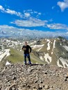
From the top of Gunsight Couloir, Maroon Lake in center right.Looking west from top of GunsightLooking down the couloir.
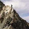
I was excited to finally be out of snowshoes, but nervous because I didn't really know how to navigate around Gunsight Tower, and had read from other reports that it's not easy. When I first started across towards the tower and in the direction of N Maroon I was descending a bit until I hit a dead end and needed to go up. After gaining some elevation I started to see what I assumed was the way across the tower. The first sketchy section didn't look too bad, but I was plunging axe with each step nonetheless.
Looking back on the first sketchy section. Wasn't too bad, but definitely a no fall zone.
I then rounded the corner and saw what would be the crux of the day.
The crux of the route.
The good news was that I could clearly see this was the way. Drop any lower and I'd still be dealing with hella steep snow, and I could see that the end of the tower was right there.
I said a prayer or 4 and started across. My technique was to face in, plunge axe as far as I could, and kick front point in as hard was I could, which was generally about halfway. The snow felt stable, and while this is among the sketchiest things I've ever done on a mountain, I never felt like I was in danger of falling.
The crux, from the other side. I always try to accurately depict stuff like this, helpful that newest iPhone software shows a level on the screen for pictures.
After the crux I was at the top of Trigger Finger Couloir, which runs down the opposite side of the mountain. I was now feeling good, as the remaining route to summit was one that I had done before, in May of 2022. It's not an easy route, and there was more snow than in May of 2022, but I at least had some familiarity with it. I didn't take many pictures, wish I had, but there are a few challenging moves needed on this stretch to reach summit. Weather was relatively good, there was an occasional wind gust, but the 20 mph wind forecast felt spot on. There were 2 places on the ridge where I had to move to the north side of the ridge and sluff through deep powdery snow, but nothing on the ridge felt particularly hard or dangerous.
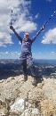
When I finally reached the point where I could see the summit, I started crying. I couldn't believe I was about to accomplish this. I'm not terribly emotional, I cried when I lost my cats, I cried when my mom had a stroke, but this is the first time I've cried on a mountain. It was a great, happy cry that I repeated when I reached the summit a few minutes later.
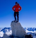
Reached summit in 12 hours and 45 minutes from start. It was a bit cloudy at first, mostly off towards S Maroon and Pyramid. I spent a half hour or so at summit chatting with my SAR crew, taking pictures and enjoying some more peanut butter eggs. Just as I was getting ready to pack up the clouds cleared a bit for some better pictures.
Great views of the Bell's Traverse and Colorado's finest fourteener.Pyramid just wasn't interested in showing today.Snowmass and Capitol off in the distance.Zoomed in on Snowmass and CapitolZoomed in a little more
Maroon Lake in center.
After getting plenty of summit shots it was time to start making my way down. Wasn't difficult to retrace my steps as most of them were in snow.
Soon enough I was back at the crux.
Gunsight tower. From this angle it looks like it might be possible to go over the top, but I decided to stick with the devil I knew and repeat the snowy traverse.
After repeating the same maneuver that got me across the first pass, I felt a huge weight of relief, now all I had left for danger was getting down the couloir, which wasn't nearly as terrifying as what I had just strafed across.
More of Colorado's finest fourteener on the way down.
When I made it back to the couloir I put my snowshoes on my pack, finished off my 4th bottle of Powerade and started down.
Looking down Gunsight Couloir
Once I was safely down from Gunsight, I did my last wardrobe adjustment of the day, it was pretty warm out. Snowshoes went back on, went back down to 2 layers, put a little sunscreen on, and messaged my SAR crew that I was unlikely to die today. Now I just had a 12-13 mile walk to get back to the car. My tracks were mostly blown away until I was a bit into treeline. I was glad to be on my way, and looking forward to getting some pictures of the basin now that I had daylight.
Return trip was mostly uneventful, and took forever, as expected. I started really feeling tired and worn out around the time I was back rejoining the Snowmass Creek trail, which is still 8-9 miles to go. Hadn't had much postholing until this point, it was a pretty warm day. At least my tracks were easy to find for the most part.
Made it back to the car before dark, ready to down a bunch of Diet Mt. Dew on the 4 hour drive home, hoping I wouldn't have to pull over for a nap along the way.
Stats from Apple Watch. For crazy long days like this I turn on "ultra low power mode" which reduces frequency of heart rate checks and GPS pings. Unfortunately it also often generates wildly optimistic elevation gain. I'd guess actual elevation gain was 7k or so.Stats from Garmin InreachGPS track from Apple Watch.
This trip was an incredibly memorable way to finish off a 6 year journey of seeing Colorado's highest points in the best season.
Thanks for reading.
Thumbnails for uploaded photos (click to open slideshow):
I am astonished at this feat. Lord have mercy you are strong!!! that traverse is awesomely scary. Nice work man. Incidentally, I had a stroke two years ago after summiting 7 of these during the summer. It Took all my strength, muscle mass. stamina, Endurance. Im gonna keep trying to get back up there, and you inspire me man,!
What an incredible peak to finish on - and incredible feat in itself to finish the winter 14ers. You are very inspiring to myself and I know many others. Huge congratulations on this amazing accomplishment.
Even though theres not many photos, the ones you took are
unreal - so beautiful. Also, the crossing around Gunsight Tower had me sweating. You are a machine, Will!
Way to go, that is an awesome accomplishment. I can't believe the milage and vertical gain you racked up, in deep snow non-the-less. What a day and way to finish, Sheeeeshh!!!
This is one of the only trip reports that I've actually taken the time to read instead of just skim over. You're a beast!! Awesome work!
Can't believe we missed meeting by a mere 50ft at Kilpacker TH in early July this summer. Hopefully I'll catch you on another summit hike sometime!
Thanks all, the support of this group and site is really fantastic.
Ben: I never thought I'd consider going for the 583/584, but I need a list to work on to keep myself going. After I get through the bicentennials, probably will try to to the 583/584, which I'm referring to as "going all the way"
Randy, my mom's stroke was really tough, easy to remember the day as it was the day after I did winter Holy Cross in January 2021. Mom lost the ability to move anything on the left side of her body, she lives in a nursing home. Its rough.
Brodes, might get back up there this summer, I want to do all 3 Wilson peaks in a day loop, we had planned that but after getting to Mt. Wilson we changed plans.
Geo, S Maroon is the happiest place on earth, whether standing on it or gazing upon it. If you don't love that peak, its because you haven't spent enough time on it
on this monumental effort, and completing your goal!
Your 2nd photo towards S Maroon is especially wall-worthy and reminds me why winter peakbagging is so awesome.
Strong work! Great write-up as always. Thanks for sharing.
Caution: The information contained in this report may not be accurate and should not be the only resource used in preparation for your climb. Failure to have the necessary experience, physical conditioning, supplies or equipment can result in injury or death. 14ers.com and the author(s) of this report provide no warranties, either express or implied, that the information provided is accurate or reliable. By using the information provided, you agree to indemnify and hold harmless 14ers.com and the report author(s) with respect to any claims and demands against them, including any attorney fees and expenses. Please read the 14ers.com Safety and Disclaimer pages for more information.
Please respect private property: 14ers.com supports the rights of private landowners to determine how and by whom their land will be used. In Colorado, it is your responsibility to determine if land is private and to obtain the appropriate permission before entering the property.


")
")
")
")
")
")
")
")
")
")
")
")
")
")
")
")
")
")
")
")
")
")
")
")
")
")
")
")
")
")
")
")
")
")
")
")
")
")
")
")
")
")
")
")
")
")
")