| Report Type | Full |
| Peak(s) |
Washington Mountains: Mount Rainier (14,410ft) Dragontail Peak (8,842ft) Colchuck Peak (8,706ft) |
| Date Posted | 06/27/2024 |
| Modified | 07/01/2024 |
| Date Climbed | 06/23/2024 |
| Author | cloudkicker |
| Cascade Consolation Climbs: From Disappointment to Enchantment |
|---|
|
THIS IS A 2-IN-1 TRIP REPORT. CLICK HERE TO SKIP DOWN TO THE SECOND CLIMB. Cascade Consolation Climbs: From Disappointment to Enchantment Primary Objective: Mount Rainier - 14,410ft
Range: Cascades (WA)
Route: Disappointment Cleaver
Details & Dates: Guided (RMI) - 6/18/24-6/21/24
Outcome & Reason: Did Not Summit - Avalanche Danger (Wind Slab)
Highest Point Reached: Top of Disappointment Cleaver - 12,300ft
Intro: Preparing for the ‘Biggun’
I knew for months that Mount Rainier would be a personal focal point in 2024. In years past, I let a few opportunities pass me by to climb Rainier unguided. I watched from home on more than one occasion as Colorado friends ventured to the PNW, each group reaching the top of Rainier with aplomb. So, as I recovered from an extended bout with COVID in winter, I resolved to get my act together and finally make this climb happen. I received notice from RMI in February that a spot had opened up for a 4 day guided climb in middle June. I paid in full and began ramping up my training. In March, I was matched with a personal trainer at my city’s rec center. We formed a rigorous 12 week training program, knowing that Rainier is much more physically demanding than your average Colorado 14er. The program consisted of strength training workouts, high intensity intervals, vinyasa yoga, and my usual cardio regimen of hiking, cycling & running. Midway through the 12 weeks, I replaced the HIIT workouts with more zone 2 aerobic volume. It all paid off. Spring couloir season arrived in Colorado. To prepare for Rainier, I took a repeat lap up the Cristo Couloir on Quandary Peak. I climbed moderate snow up the south slopes of Coffeepot Mountain. Then, just three days before my flight to Washington, I finally nabbed Cathedral Peak in the Elk Range via the standard couloir after years of anticipating that climb. 
By the end of my training, I was finally able to see tangible results from my springtime summits and strength gains, mere months after COVID forced me to turn around on dinky Mount Democrat during the winter solstice. It didn’t fully come together until the final weeks of my training, but I actually felt ready for Rainier. The Lead Up: Getting There, Orientation, Mountaineering School On my Denver to Seattle flight, I sat next to two 20-somethings. We were all strangers at first, but friends immediately. There was Alyssa, a raver girl from Cali taking the long way to Electric Forest (LA to Denver to Seattle to Michigan. make it make sense!!!). Mitch is a dorky archaeologist based in Packwood, WA, not too far from Rainier, who had gone back east to see family. We cracked jokes all flight and airdropped memes to each other. I’ve had several flash-friendships in my life, and these two made this the most fun flight of all time. Mitch and Alyssa exchanged numbers at the baggage claim and wanted to stay in touch with me as well but I figured I’d bid happy trails and let fate choose if or when our paths might cross later. I wanted the two west coasters to keep the connection. The fondness of my memories for them were enough for me, and we all said goodbye. 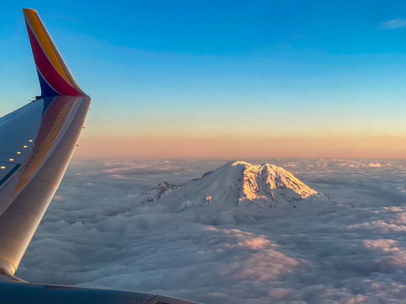
I stayed the night with my aunt in the northern Seattle suburbs, sitting down for breakfast with her the next morning before rushing on to Ashford. I underestimated the terrors of lunchtime I-5 traffic through Seattle and Tacoma, and had to call RMI headquarters to let them know I was running 15 minutes late to group orientation. 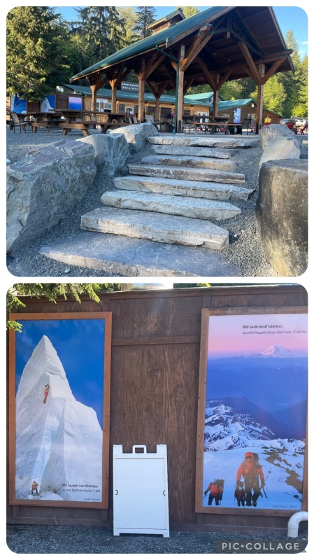
Upon arriving at RMI’s Base Camp HQ, I was escorted to the briefing room. I met Brent, our soft-spoken lead guide and a real living legend. He has completed multiple Everest climbs, one of which was in search of George Mallory’s lost expedition. Brent also casually holds the all time record for most Rainier summits with 592. 592!!! Through the gleam in his eyes, you can just feel his undying passion for this mountain. My fellow clients: Matt (a professor from New York), Kiran & Jason (both doctors from Wisconsin), the couple Seth + Jess (finance guru + software engineer from California), and Oliver (an Australian software engineer based in Seattle). Two more clients would be joining our party for the actual climb — Casey and Curtis — two upbeat, macho dads from Houston, TX who were making their 5th attempt at Mount Rainier! They had just attempted 2 weeks before and due to avalanche risks did not summit. Since it was their second attempt this season, they were able to bypass the first two days and join us on our trek to Camp Muir, day three. During orientation, Brent took us through a slideshow of the climb along with expectations, then led us out to the pavilion to do a shakeout and evaluation of all our gear. We received the next morning’s rendezvous instructions, and thus concluded orientation day. I enjoyed a tasty salmon burger at the RMI base camp grill for dinner before seeking out my Airbnb to rest. 
After a full night of sleep and a quick breakfast, it was time for mountaineering school. Avery, an energetic, charismatic female guide joined us and we were shuttled to Paradise for the short hike up to the “learn slope”. Avery and Brent walked us through a bunch of topics: mastering the rest step, breathing techniques, walking with crampons on, team arrest and self arrest, glissading, traveling while roped up, running belays, the use of avalanche transceivers, and more. 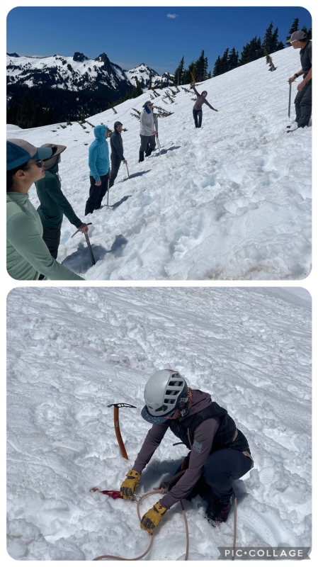
Bottom: Avery shows us how to clip in to and out of the pickets found on the upper mountain. During mountaineering school, I eagerly absorbed every piece of information I could, even for the things I sort of already knew. It was great being able to work with professional guides to improve my self arrest form, while bolstering other existing skills, as well as introducing plenty of new practices crucial to glacier mountaineering. At the end of the day, I ran into my fellow ginger Oliver as we happened to simultaneously arrive at the Wildberry Himalayan restaurant. We sat at the bar, inhaling spoonfuls of Sherpa Stew as we discussed the day, takeaways from mountaineering school, and general mountain gossip. The Wildberry is known for its Marionberry Pie so we each took slices to go, settled our tabs, and parted for the night. The Main Event: Disappointment on the ‘Biggun’ By the morning of day 3 and our departure for Paradise & Camp Muir, news had spread that unstable snow above the Cleaver was turning back every single guiding company and independent party all week. At this point most of us knew that the summit would be a long shot. This news resulted in one member of our group bowing out of the climb to take an earlier flight back home. The rest of us were eager to make the best of the trip anyway. We met Casey and Curtis, along with our third guide: an avalanche forecasting guru from Bozeman and Taos named Charlie. Off we went in the shuttle again, heading for Paradise TH at 5,400ft. 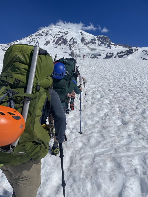
We had come to the first big grind, the first true test. Roughly 4,700ft of gain and 4.5 miles separates Paradise from Camp Muir. Later in the season, the lower reaches of trail are dry, but for us the entire approach was on snow. RMI will use this approach to Camp Muir as pacing practice before the summit day, and to observe the abilities of its clients. The name of the game is, maintain a steady single file pace behind the leader. Hike for roughly 1-1.5 hours and 1,000-1,300ft, at which point the group will take a 10 minute break. Repeat this rigid but highly effective process a few times until there’s no more incline left. The goal with the breaks is to be as efficient as possible. Pictures are okay but only after you’ve taken care of sunscreen, hydration, nutrition, and layering. This is RMI’s typical way of doing things on its climbs, and I suspect it mirrors bigger expedition climbs as well. If you can move efficiently but conserve energy, and make the most of every minute of time during breaks to adjust or refuel as needed, you will fit right in. Everyone was in fairly good spirits, and I felt strong and energized as each of our three guides took turns alternating between making small talk and leading the march. I did not suffer any fatigue while in full conversation mode on the uphill, which I thought boded well for my chances. A little over 5 hours after leaving Paradise, we made it to Camp Muir at 10,000ft. Everyone picked a sleep space inside the cramped bunkhouse and we settled in. Then Brent (and the other RMI leader) pulled all the clients into the bunkhouse to discuss the summit day with us. This is when we received the news: we would not be able to attempt the summit. Of course, the displeasure was palpable. As I mentioned already, two of our group were attempting Rainier their 5th time, these two would have to walk away empty handed once, after a great degree of shared optimism over the last week that good weather would bring favorable conditions. Mount Rainier in early summer is a fickle beast. Yes, the weather was perfect, but nobody could control the last storm creating snow stability problems above 12,500ft. Countless other groups have been turned back over the years, often for the opposite problem — great route conditions, but poor weather. All I could contribute to the conversation is that I hired RMI to help manage risk on the climb and I appreciated that they were doing just that. The First Consolation: Climbing the Cleaver Instead of a full summit attempt, the plan would be to “sleep in” until 2:30am (lol) and head up to Ingraham Flats for sunrise. At that point, roughly half the climbers would proceed to a broad landing atop the Disappointment Cleaver before returning down the mountain. The other half would partake in some crevasse rescue exercises nearby Ingraham Flats. 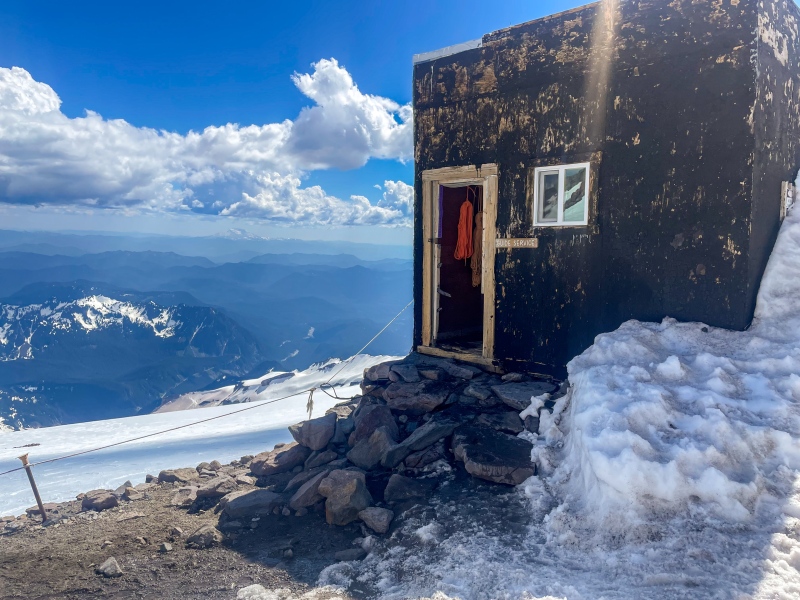
Mount Saint Helens with the blown off top and snow capped eruption debris trailing northwards looms in the distance. Despite the no-go news, I was still excited. I buzzed energetically around Camp Muir the rest of the evening. I made friends with other RMI clients not in my direct group, along with some homies from Utah who had skinned up with beers in their pack and were eager to shred the most perfect spring snow. I was so jealous of their ski down the Muir Snowfield back to Paradise. At some point, I checked my phone and my aunt mentioned having the live webcam loaded up for Camp Muir. She was able to get a screenshot of me standing in front of the webcam to send to other family! Super cool and it inspired a couple of the other climbers to do the same. (I sadly did not have room to attach the pic to this report). 
Somehow, I was smart on this climb and I packed both a battery powered clippy fan and Bluetooth earbuds with a white noise soundtrack downloaded to Spotify. These helped me mimic my normal sleep routine sufficiently enough to fall asleep right at Hiker’s Midnight (9pm) and get a solid 5 hours of sleep inside a crowded and slightly odorous bunkhouse. Morning came too quickly nonetheless. The guides nudged us into breakfast, caffeine, bathroom, getting dressed, etc. Then we were roped up and heading out, crossing the Cowlitz Glacier on our way to catch the sunrise at Ingraham Flats. 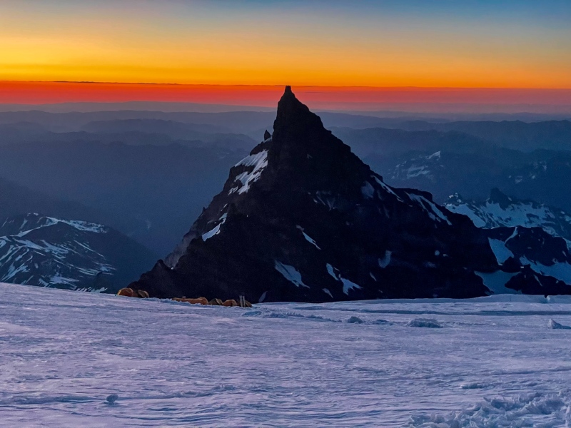
I was extra stoked this morning because Brent chose me to be right behind him on his rope team, in the very front! Casey and Curtis rounded out our rope team and the other 5 RMI rope teams followed behind us. Knowing that safety is paramount to ensuring safe roped snow travel, I made sure to listen to and apply every command from Brent as we continued up the route.  
Climbing up the Disappointment Cleaver feature itself was something of a challenge. The entire 1000ft rock feature was composed of ~2/3 snow and ~1/3 sharp boulders with some loose scree steps. Luckily, I have a little bit of experience climbing with crampons on small class 2+ rock sections with high exposure, so I was able to keep my balance without much difficulty. There were a couple sections in which Brent chose to cut in new switchbacks on the steep snow and these were a little unnerving, but the snow quality was great and I was in the zone. We made it to the top of the Cleaver and 12,300ft! Brent and Charlie unroped and headed further up the mountain to check the snowpack conditions and shovel the route out to help future groups proceed. Meanwhile, the rest of us hung out for a “summit length” break. We snapped photos, ate snacks and basked in the sun. Despite no summit, we were all ecstatic to be there. 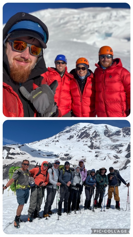
Bottom: Full group pic close to Paradise - Brent, Casey, Curtis, Oliver, Jason, Me, Jess, Seth, Kiran (PC: Avery) On the return down the DC, Brent pointed out some small fumaroles emitting steam up and out from the volcano’s depths. They are nowhere near the size of the fumaroles on Mount Hood, but as someone who has spent very little time hanging out on active volcanoes, they fascinated me nonetheless. A little later, Casey croaked out “falling” after stumbling. He fully recovered, negating any need to team arrest. He later told us he hoped Brent hadn’t heard. Both myself and Brent had our own separate stumbles while on the Cowlitz. I’ve been working hard the last few years on my footwork so that I don’t catch a crampon on a pant leg, but that ended up happening still. Super annoying, but at least it was on low consequence terrain. We returned to Camp Muir, where the other RMI clients were getting antsy waiting for us all morning. We quickly refueled and attended to our needs, then packed up our things and bid farewell to our most humble mountain abode. Down the Muir Snowfield, Avery led us in stringing together about 10 nice glissades. This allowed us to descend nearly 3000ft of elevation in under an hour! The rest of the descent went smoothly, although the lower parts of the trail were hot & crowded with some minor postholing. 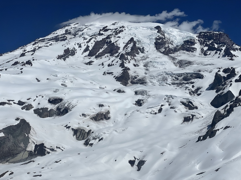
Back at Paradise, the shuttle picked us up a couple minutes later. I sat next to a fellow named Ashman from a subsequent RMI group who had to turn around on the approach to Muir Camp due to sciatic nerve pain. I’ve been in that boat before. He had that same unquenchable lust for adventure that I do, and we chatted about national parks along with cool trails and summit experiences. His 1st 14er in Colorado was none other than Mount Elbert! We reached Ashford and had our debriefing session in which Brent, Avery and Charlie presented each client with certificates and some nice words directed to each of us. It was a great gesture despite not making the summit. Brent complimented my excellent climbing up the cleaver, and said he couldn’t wait to climb with me again! Curtis, Kiran and I each ordered pitchers of Rainier beer for the group. I joked to Casey and Curtis that RMI needs a loyalty/rewards program - buy 5 Rainier trips, get 1 free. I asked Brent about former RMI mainstay Ed Viesturs. Brent shared a few memories of Ed and from the earlier RMI days in general. One more salmon burger and a little more camaraderie time at the HQ. Our numbers dwindled as the group slowly began to disperse back towards home or hotel. I said my goodbyes and left back to the north Seattle suburbs, where I would spend the next night. Some would call my climb a bust. Perhaps my friends who succeeded unguided in previous years are reading this now and questioning if it was really worth it for me to punt on all the past trips, then pay for a full guided climb but only make it to 12,300ft, leaving me with unfinished business yet again on Rainier. To me, it was worth every single penny. It all comes down to the skills I either learned or improved on during the mountaineering school along with every other learning moment through the program. It comes down to staying present and actively listening to Brent & Avery’s orders, helping me to gain a better understanding of the process and nuances on an expedition style climb. Along with all of that, it comes down to the confidence boost I’ve gained from a noticeable improvement in my conditioning and in my snow traveling skills. The icing on the cake: the friendships I made with the other clients, who each had their own unique stories and perspectives to share during those 4 days. Long before those pitchers of Rainier beer were emptied, it truly felt like we had all grown closer together as friends and as climbing partners. This is one of those gifts mountain climbing continues to provide to me, over and over. I love my solo trips. But I’ve learned that many of my closest adult friendships have sprouted through those hours spent struggling up and down the mountain, and all those moments and different perspectives shared during and surrounding those climbs. Finding Consolation: A Duo of Enchantment Objectives:
Colchuck Peak (8,706ft)
Dragontail Peak (8,842ft)
Range:
The Enchantments, Stuart Range, Cascades
Route:
— Colchuck Glacier to Colchuck Col to Colchuck Peak
— Traverse to Dragontail via Pandora’s Box couloir, ridge/snowfield traverse to summit
— Descent to Colchuck Lake via Aasgard Pass and hike out
Trailhead: Colchuck/Stuart Lakes TH
Stats: ~18 miles, ~7000ft elevation gain
con•so-la-tion | ,känse'laSH(a)n | noun |
the comfort received by a person after a loss or d i s a p p o i n t m e n t
Intro: Gather & Go My Rainier climb wrapped up late Friday. My return flight to Denver was scheduled for Monday. The original plan for the rest of the trip assumed a successful Rainier summit. On Saturday I intended to take a rest day in the suburban neighborhoods of Snohomish County. Then on Sunday I would ferry over to the Olympic Peninsula and drive out to Lake Crescent finding an easy hike along the way. If I had time, I would visit La Push for the first time since childhood and see the Pacific Ocean again. I woke up from a long night of sleep, 24 hours after being atop the Cleaver, and immediately realized those relaxed Sunday plans would be changing. I still had a ton of energy for another climb, and I could push the mileage and elevation gain much more than initially anticipated. I had expected the sunburn from the glacier to sideline me. In Colorado, my fair complexion burns easily and I am often forced to take extra rest days after a big climb. This time, all it took was some Aloe Vera gel, a ton of water, and a healthy nutritious lunch. I felt good to go! Throughout Saturday, I began to search for my consolation climb. While gazing at Mount Adams from the top of the Disappointment Cleaver (nearly level on the parallax) I mused a potential Sunday push up the south facing snowfield of Adams. I wasn’t sold on another volcano adventure, though. I expanded my search with the help of the PNW Peak Baggers Facebook group and its numerous condition reports, beta and photos of climbs by mountaineers all over Washington. I compared the beta I found to route information on Washington Trails Association’s site, which is sort of like 14ers.com but with more than just mountain climbing routes. I read some E P I C info about Eldorado Peak and salivated over its ultra aesthetic summit ridge, but the hellish ‘shwack approach dissuaded me along with the prospects of going solo. I researched a couple Olympic Range climbs. The Mount Ellinor & Mount Washington traverse looked cool, but not enough mileage/gain to satisfy. The Brothers checked the mileage box and looks like fun with a pretty lake and some cool exposure near the top, but recent reports said crampons weren’t necessary. I realized I was craving one last good snow climb before hanging up the gear for the season. My gaze then wandered eastwards on the map to The Enchantments, near the town of Leavenworth. If you’ve spent any time on social media you’ve probably seen photos or reels of Colchuck Lake. This area is kind of like the Maroon Bells-Snowmass Wilderness… insane backpacking up steep trails and rugged passes to beautiful lakes and water features, replete with jagged spires, pinnacles, pyramids and ridgelines towering overhead. The lakes and the backpacking have become so popular that you need to apply for a permit lottery to take an overnight trip. But for day hikes, no permit lottery is needed. While I was on Rainier, an awesome report was posted by someone who had JUST linked both Colchuck Peak and Dragontail Peak. Dragontail was on my radar since my last Washington visit in 2021; its name came up while I was chatting with someone on top of another Washington summit. The more I read about Colchuck and Dragontail… the more I was captivated by this option. The 26th and 32nd highest peaks in Washington, a sporting but not technical route with a few steep snow sections, in a gorgeous area of wilderness, can be done in a long day hike, and with all the views?? I was sold. I enjoyed a nice seafood dinner with my aunt at a cafe right on the Puget Sound next to the Edmonds Ferry dock. Immediately after, I left for Leavenworth. I slept in my rental at a rest area east of Stevens Pass and awoke at zero dark thirty for the easy dirt road to the Colchuck/Stuart trailhead. On the Trail: Everything’s Coming Up Colchuck I reached the trailhead at 4am and was on my way at 5am sharp. This far north, just after summer solstice there was already no need for a headlamp. 
I wore trail runners up the Colchuck Lake trail so that I wouldn’t have to spend the whole 18 mile day in my mountaineering boots. Of course, the one drawback to this plan was… the boots were in my backpack, along with 150oz of water (I drank it all by the end) and other heavy gear. My backpack felt like I was lugging up lead on the approach. Nonetheless, I decided to push the pace. 
The trail led me steeply up the Mountaineer’s Creek drainage before dumping me at Colchuck Lake, its surface roiled by a stiff breeze. I had hiked 4.3 miles in and reached the lake at 7am sharp. 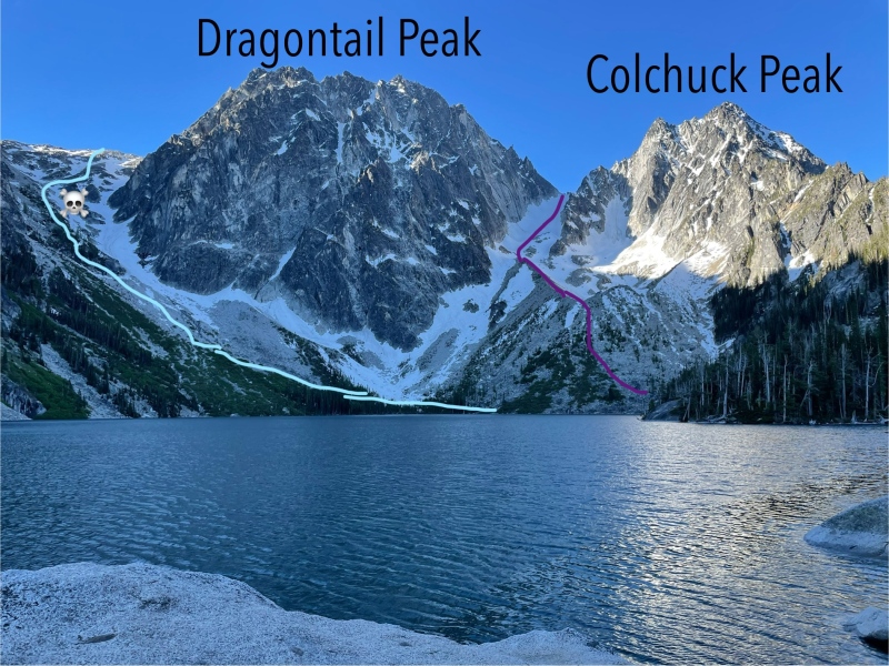
My descent would follow the light blue line down Aasgard Pass. Avoid the skull & crossbones spot, there is a deep hole hidden in the snow. Numerous people have died falling into this hole while descending the snow. As I walked around the lake, I met an older camper lady who was excited to talk to me of my plans. According to her, my routes were like a conga line of climbers the day before. From the lake, I had expected to see multiple parties climbing either Colchuck Glacier or Aasgard Pass. I was perplexed when I saw nobody up on either route. Oh well… at least there’d be a full booter all the way up! I wished her to enjoy her day and moved on. 
At first I thought the breeze at the lake had ruined my peak reflection chances. 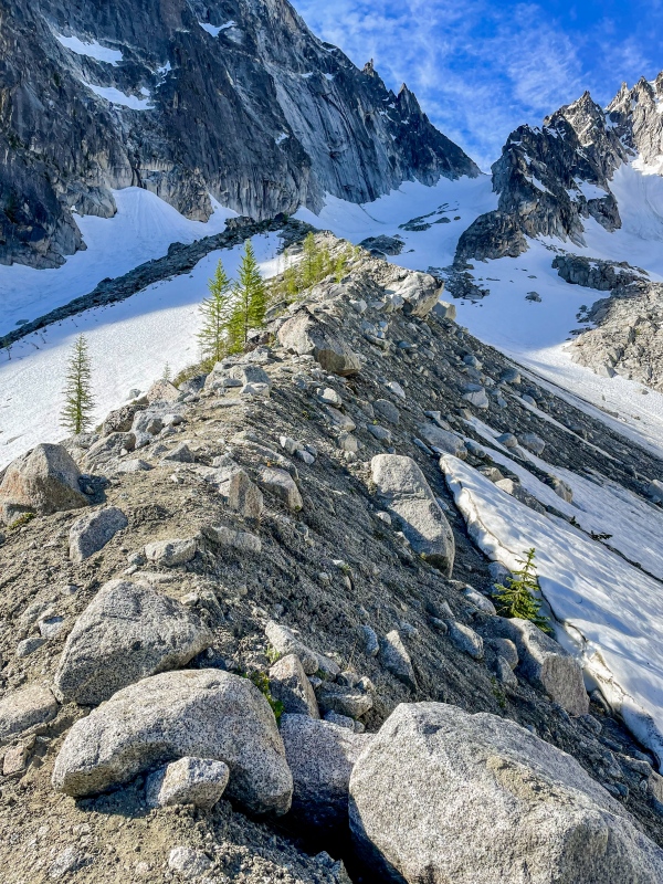
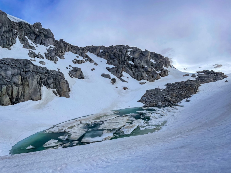
The conditions report I read suggested to enter the glacier higher up due to thin trap door coverage lower on the glacier. 
I passed a single young mountain goat on the ridgelette who let loose a small rockslide but was pretty cool around me otherwise. 
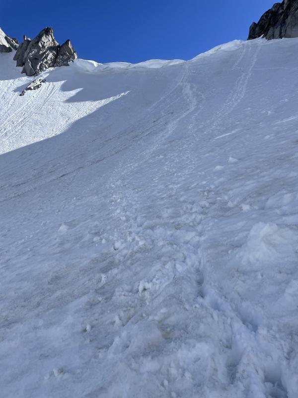
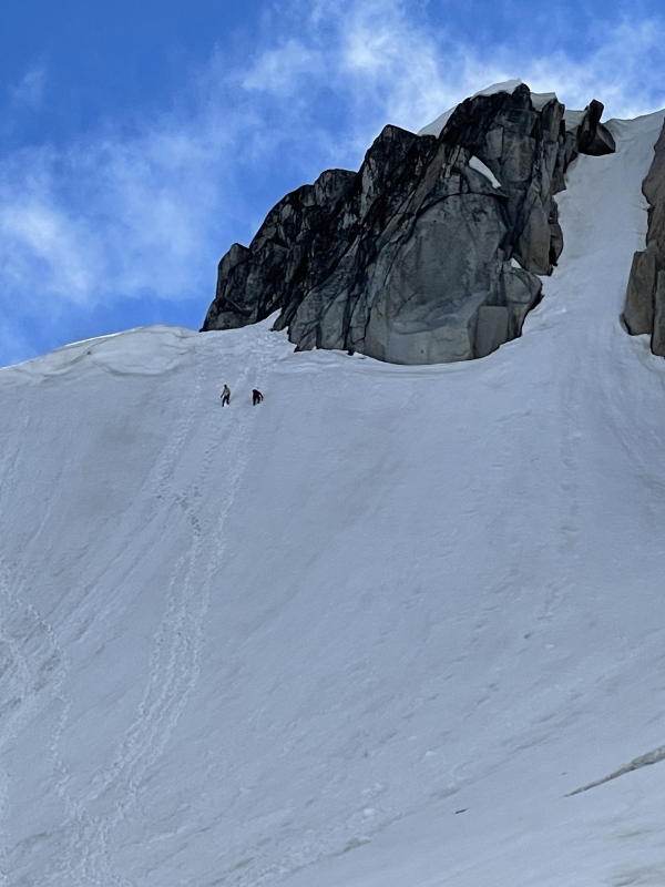
At the top of the ridgelette, I swapped into my mountaineering boots and attached my trusty Petzl crampons, preparing to enter the glacier. It was at this moment that I heard the voices of two male climbers ascending the lower part of the glacier. They seemed pretty friendly and greeted me as I transitioned. I first called them the bros. For vanity purposes, I decided to try and keep up with the bros on the way up the glacier. Pictures on snow climbs are always so much better when you have other climbers in view. I shouted out to the bros that I would be getting some epic pics of them in case they wanted to return the favor. They were happy to do so. There were multiple booter lines heading up which made for easy travel up the glacier. Snow quality was magnificent. 


I introduced myself to the bros and learned their names are actually Dylan and Ethan. It was Ethan’s first ever snow climb, which kind of blew my mind since your typical Coloradoan’s first climb ever is usually an 11am summertime hike up Bierstadt with a single 16.9oz water bottle. Meanwhile, Ethan’s crampons were strapped to a pair of trail runners and he was powering up this thing! Dylan had several years of ski mountaineering experience and was very present throughout helping Ethan feel comfortable on the spicy bits. After a short break at the col, we stowed our crampons and forged ahead up the final 800’ to Colchuck Peak. The terrain was mostly a scramble with a few class 3 moves, a few easy snow sections, and a few flat sections. 
Notice the dramatic couloir behind us on Dragontail. Our first full glimpse of Pandora’s Box. Roughly 30 minutes after leaving Colchuck Col, I clambered on up to the top of Colchuck Peak. There was about as much room on the top as the typical Colorado 14er summit, while also offering plenty of opportunities to look over the side and get as much exposure therapy as you can stomach. 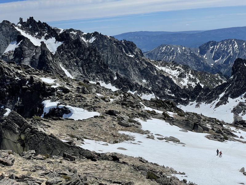
Dylan and Ethan joined me. We lounged lazily on the summit for 45 minutes. I enjoyed a few slices of chicken sausage & veggie pizza I packed in from my lazy Saturday. The winds, which were present for much of the hike, calmed down during most of our time up there! 
The North Ridge is considered a premiere mixed alpine route. It goes at ~5.4-5.9. In front of Mount Stuart is Sherpa Peak (left of center), another classic climb. 
Its ribbon of high snow, and the jagged ridge between Colchuck and Argonaut, amazed me. 
The cool thing about the PNW Peak Baggers group is I can identify exactly whose tracks those are by looking at the most recent Argonaut post. The group is super active. Those tracks belong to two badass mountaineers named Selena and Beverley who climbed Argonaut the day before! Some day I hope to be 1/10th of the climber these ladies are. Incredible. 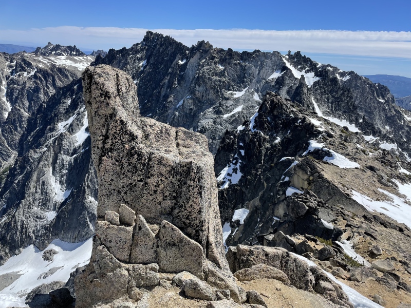
Sadly I found the Colchuck Chair after Dylan and Ethan had gone down already. Someone, please go get a pic of you sitting on Colchuck Chair. For science. One of the lowkey hardest parts of the day was leaving Colchuck’s summit. I never wanted the summit chilling to end. But end it did, and we found ourselves retreating to Colchuck Col. Dylan and Ethan’s pace ended up being similar enough to mine that we decided to continue teaming up. The Traverse: Pandora’s Box & the Belly of the Beast 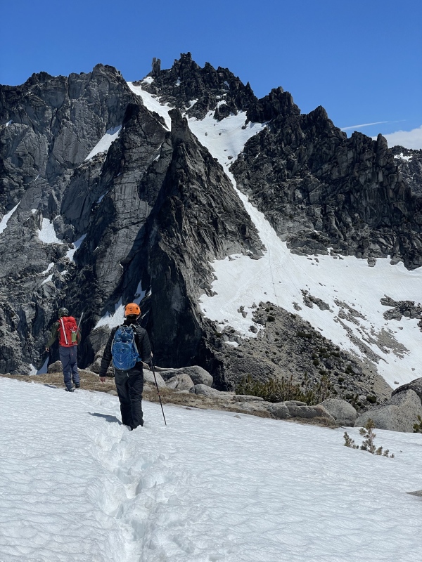
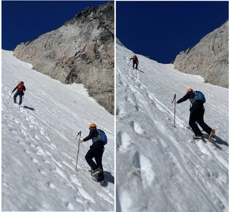
Back at Colchuck Col, one of the bros expressed a bit of altitude sickness concerns (headache and a brief dizzy spell). Thankfully, ibuprofen took care of that fairly rapidly. The main concern I had was timing. It was already 1pm. I have never in my life climbed a couloir so late. Never have I committed to down climbing a couloir even later! But I knew that Colorado snow is notorious for being more twitchy and prone to slides than regions like the PNW. I knew those same Colorado rules don’t always apply to a settled snowpack at 8000ft in Washington. And the temperature above 7000ft was maybe 40 degrees tops. It wasn’t hot by any means. At Colchuck Col we ran into two other climbers who would be doing the same route. They apparently had lots of experience in the area and said with a great deal of confidence that the snow would be supportive the whole rest of the day, as long as we didn’t climb onto any cornices. We chose to trust but verify. (((I’ve committed to finally taking my AIARE 1 this winter with a couple of friends in order to make more informed decisions when traveling on snow. Dylan, Ethan and I decided to scramble up to the entry of Pandora’s Box and check out the snow quality in the couloir for ourselves. Once again there was a full booter going up Pandora’s Box. We took a few steps out onto the apron and I plunged my boots in deep. We noticed no roller balls or instability at all. So we decided to send it! 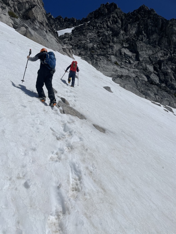

A nice sitting rock halfway up the couloir would allow for a short break. Plenty more mirin’ of Argonaut, Sherpa, and Stuart left to do. Dylan and Ethan made quicker work of the couloir than me. The girl who authored the PNW Peak Baggers report for this climb suggested instead of topping out, we exit climbers left 50ft below the top out onto a solid class 3 granite rift, avoiding a very steep downclimb on the other side, and gaining more easily negotiable terrain. Dylan had also read this report and was familiar with this beta, but couldn’t locate the proper scramble line that would let us exit Pandora’s Box onto Dragontail. I stepped in and offered to find the class 3 route with the help of my background scrambling. I located the exit, and we removed our crampons and broke through onto the heart of Dragontail Peak, the belly of the beast. 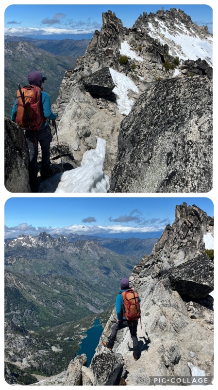
From there, a broad landing to regroup and choose our remaining route to Dragontail. (PC: Dylan) 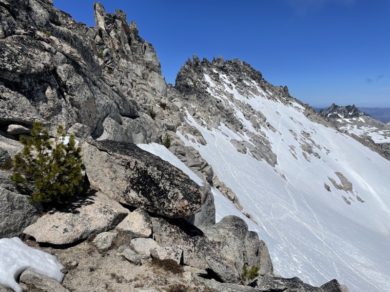
I made the mistake of stubbornly wanting to stay high simply to avoid putting crampons on again, 10 minutes after removing them for the couloir exit. Ethan followed me, while Dylan wisely hopped on down to one of the snowfield booters. Some of the scrambling we encountered while staying high ended up going at stiff class 4 and there was a bit of backtracking and creativity required to find a safe way through. Dylan ended up easily beating Ethan and I across. 

Dragontail’s false summits form a jagged crown. Just wow. One of the greatest summit views of my life. This is a peak I would definitely repeat just for that summit view, not counting all the amazing moments on the climb itself. I couldn’t get enough of it. 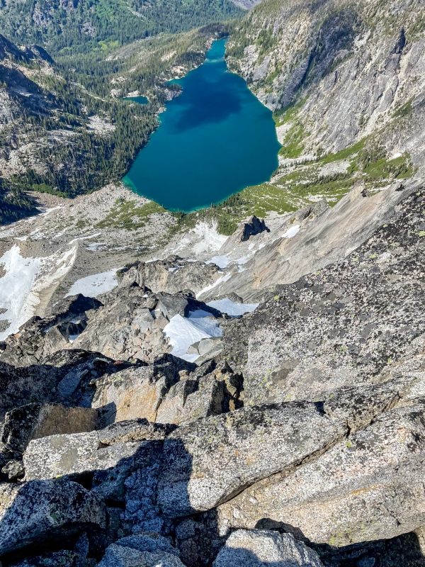
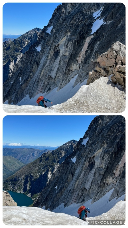
I struggled to comprehend that the lake was nearly 3,300ft below us. Unfortunately, clouds were starting to smother the peaks just west of us, bringing the potential for visibility issues. To further enhance that problem, we were committing to a different descent route which made visibility a luxury we couldn’t afford to lose. As we had already taken more time than necessary checking out the snow quality on Pandora’s Box, and then negotiating the ridge scramble, we cut our summit time down significantly. We spent 15 minutes on top of Dragontail and began down. The Descent: Safe Passage Through Aasgard 
The left chute across the way is the other side of the Pandora’s Box top out. We bypassed that chute by exiting early to gain the ridge. 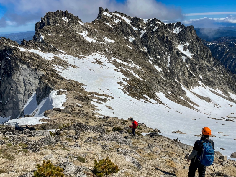
We followed the standard/summer route down, and shortly reached the top of our final crux — a wide chute with 100-200’ of steep 45+ degree climbing before it mellows out considerably. We put our crampons on again and spent a few minutes here scouting out the two possible routes, checking snow quality and coming up with a game plan to avoid triggering the collapse of the cornices that guarded the snow’s crest. 
Light blue is steeper but less risk of trouble from the cornices. We elected to go one at a time down the middle option, descending looker’s left once off the steeper terrain to get out of the cornice fall line. I’ve always had some mental difficulty facing in and taking the first few steps down from the top of a steep snow climb. At first I offered to take the lead on this section, but I made it about 3 steps down and asked Dylan to go instead. We changed places and once again he showed off his ski mountaineering prowess by handling the steepest part with ease. Then it was Ethan’s turn, then me. It’s a little less heady when I don’t have an audience of people watching me do this stuff with bated breath. The first steps down felt steeper than anything I’ve downclimbed since the Snowmass semi-direct finish years ago. But I was ultimately in a great headspace, all things considered. Once again, the snow quality was just fabulous. Any time I needed to kick in a deeper step, the snow let me take whatever I needed. My ice axe plunged in with ease and stayed firmly in every single time, giving me confidence that if I slipped, I’d arrest well before an actual fall. It was well bonded snow at 8,000ft in the middle of the afternoon in June. This blew my mind. Why can’t Colorado snow be more like Washington’s?! 
One of them was feeling so comfy he faced out and plunge stepped the whole way down! 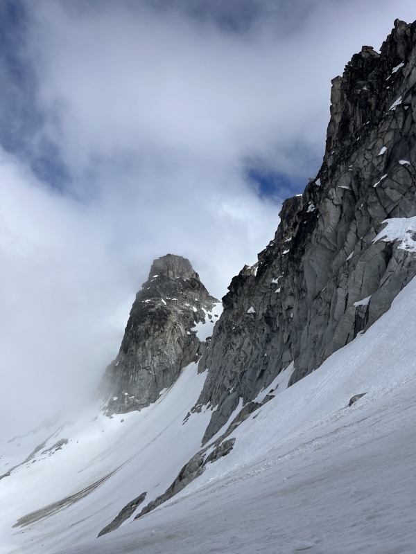
We easily plunge stepped down, traversing on a mellow glacier until we reached the top of Aasgard Pass, where we swapped out of our mountaineering boots and into trail runners for the rest of the descent. Aasgard Pass at 7,840ft is nearly 2,400ft of elevation higher than Colchuck Lake. There was still a lot of down left to go before we could engage any form of cruise control. The Aasgard Pass descent was a mixed bag of broken cairned trail, loose dirt, chossy rock steps, patches of snow, wet slippery granite slabs, coniferous vegetation, and an endless talus field reaching up from the bottom to thrust further tedium upon us. All difficulties and annoyances aside, it goes fine. It seems like Aasgard Pass is the crux for people who backpack into and out of the core Enchantments area. That is to say, some day when I come back and backpack deeper into the Enchantments to tag the other peaks, I’m not looking forward to climbing up and over Aasgard Pass again. 
It has swallowed and killed a number of people. Avoid at all costs. The hole is on skiers/lookers left (climbers right). Make sure you follow the cairns or gpx to send you lookers right. 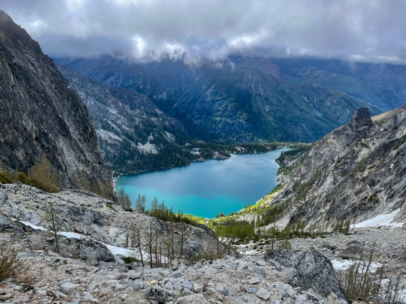
EVENTUALLY we made it back down to the lake and found our way to the base of the rock field below the Colchuck Glacier, where our main ascent had begun hours earlier. At this point, I shared one last rest stop with Dylan and Ethan. We all agreed that the last 4-5 miles out would be best left for earbuds and turning the mind off with some upbeat music. Best to just kick it into high gear with whatever energy remains and briskly crank out those last few miles in peace and quiet. So we traded airdrop photos one more time, exchanged names for the Strava add, and shared a few thoughts on how awesome that climb was. Then I cut them loose, allowing them a 10 minute head start to jog out those cruiser miles. I somehow found my 7th wind shortly after I left the lake. I also ended up running a majority of the 4 miles down, large backpack and all. Home: Final Thoughts My flight delivered me back to Denver on Monday evening. Much of that day was spent catching up on sleep and organizing my luggage before rushing to the SeaTac rental car facility. Yet throughout the whole day and this whole week, I couldn’t stop reflecting on this trip. Present tense — I still can’t stop. My mountain high has yet to release its hold of me, and it’s a more intense high than any post-climb I can recall, at least recently. Both parts of the trip — Rainier and the Enchantments — were SO rewarding. So many amazing places. So many new and existing skills put to the test. So many great people encountered along the way. With this, I’ve capped off my 2024 snow climbing season. 5 snow climbs later, I am satisfied. I never thought the outcome of “unsuccessful Rainier bid” would leave me as content as this, but here I am! Through it all, the need to return to Washington in the coming months and years will continue to occupy a large space in my heart and my soul. Colorado is and always will be my home, but there’s nothing wrong with a cheat week or three every once in awhile in which I absorb every single moment of presence somewhere else — on a high volcano, a glacier field, a granite peak with a jagged crown, or a desolate fire lookout. Until next time, Washington! Thumbnails for uploaded photos (click to open slideshow): ")
")
")
")
")
")
")
")
")
")
")
")
")
")
")
")
")
")
")
")
")
")
")
")
")
")
")
")
")
")
")
")
")
")
")
")
")
")
")
")
")
")
")
")
")
")
")
")
")
")
|
| Comments or Questions | |||
|---|---|---|---|
|
Caution: The information contained in this report may not be accurate and should not be the only resource used in preparation for your climb. Failure to have the necessary experience, physical conditioning, supplies or equipment can result in injury or death. 14ers.com and the author(s) of this report provide no warranties, either express or implied, that the information provided is accurate or reliable. By using the information provided, you agree to indemnify and hold harmless 14ers.com and the report author(s) with respect to any claims and demands against them, including any attorney fees and expenses. Please read the 14ers.com Safety and Disclaimer pages for more information.
Please respect private property: 14ers.com supports the rights of private landowners to determine how and by whom their land will be used. In Colorado, it is your responsibility to determine if land is private and to obtain the appropriate permission before entering the property.