| Report Type | Full |
| Peak(s) |
South Arapaho Peak - 13,408 feet North Arapaho Peak - 13,513 feet |
| Date Posted | 07/21/2024 |
| Date Climbed | 07/21/2024 |
| Author | Hiking_TheRockies |
| Pushing Comfort Zones: South to North Arapaho Peak | ||||||||||
|---|---|---|---|---|---|---|---|---|---|---|
|
South Arapaho Peak to North Arapaho Peak July 21 2024 10.7 Miles RT 4200 Feet of Gain Splits:
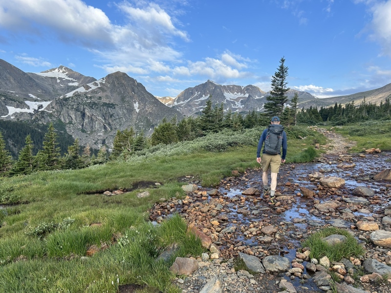
INTRO The Arapaho Peaks traverse is one of the more well-known traverses in the Indian Peaks Wilderness, connecting the two of the IPW's highest 13ers via an aesthetic, albeit relatively short, ridge. This ridge also serves as the primary western headwall for the Arapaho Glacier, one of the final remaining glaciers in Colorado. Due to this, the eastern side of the ridge is incredibly steep, glaciated, and covered in various couloirs and snowfields for the majority of the year. The western side of the ridge, facing south of Lake Granby, has cliffs and couloirs of its own that become nearly endless fields of talus and scree during the summertime, creating an interesting (or maybe horrifying) mountaineering experience for those who have scrambled off the western side of the ridge... or at least, that was my experience! I haven't written a trip report on this website since 2022. The main reason behind this is that I haven't climbed anything particularly interesting in the past two years... my attempts to climb 14ers have led me to a handful of Sawatch summits and Pikes Peak, all of which were worthy adventures of their own but had nothing that spurred me to spend a couple hours of my day writing on that one Colorado mountaineering website that I visit far too often. However, I think the most valuable thing hunting 14er summits has given me is a love for mountain climbing itself: about three years ago all I could think about was trying to climb the 14ers, and now I want to climb the 14ers and every other interesting, gnarly, or just gorgeous mountain out there. The 14ers still hold a massive presence in my life, but gaining the skills required to climb them made me realize how amazing all the other summits out there are—which leads us to today's story. About four weeks before this traverse I climbed South Arapaho Peak for the first time during a backpacking trip with the summer camp I attend, during which many interesting things happened (tents blowing into lakes, entire bags of butterscotch chocolate chips being consumed for dinner, etc), but one of the more memorable moments for me was standing on top of South Arapaho and staring at the ridgeline that spanned the roughly mile distance to North Arapaho Peak, which sat about 100' higher than us on the other side of the Glacier. I'd known about this traverse for a long time, from a combination of guidebooks and browsing this website, from which I learned that the ridge went at an easy 4th class and was a great first step into more "advanced" scrambling. As mentioned above, pursuing the 14ers has led me to find additional interest in other mountains, leading me to develop the recent goal to climb every 13er in the IPW and RMNP before I go to college—and with more than half of my remaining 14ers holding a Class 3 rating or higher, the South-North Arapaho traverse immediately stuck out to me as a way to hone my scrambling skills and move closer to my 13er goals. And after laying eyes on the ridge, I knew I had to check it out. The opportunity to attempt this ridge popped up two days before climbing it. My original plan was to climb Mt. Princeton with my Dad, who has been my climbing partner for my entire mountaineering journey thus far. We both wanted to get more scrambling experience, and when we saw a terrible forecast for our Princeton climb, I suggested we switched objectives to something much closer to our house to allow for a better time window. The Arapaho Traverse popped into my mind; I made the suggestion and he figured it would be a good way to test ourselves. And thus, our plans to give this ridge a go materialized. ROUTE BETA In prep for this climb I mostly used the 14ers.com route and a couple of trip reports. This report isn't super beta heavy so here's some good sources that I found helpful: https://www.14ers.com/php14ers/tripreport.php?trip=19638 https://www.14ers.com/route.php?route=201209181010126208 https://www.summitpost.org/arapaho-peaks-traverse/155844#google_vignette THE APPROACH We rolled into the 4th of July trailhead a couple minutes before seven. The Hessie trailhead was completely slammed, to the point where I thought 4th of July would also be filled to the brim—luckily for us, there were parking spots aplenty. We starting hiking at a very satisfying 7:00 am. The approach to South Arapaho is by far one of the prettiest approaches I've ever done, as the views of Mt. Neva and Mt. Jasper are second to none—its a steep four miles, but worth it in my eyes. We reached the summit of South Arapaho Peak at just after 9:20 am, putting us at roughly two hours of total hiking time, excluding stops. Some weather apps had told us to expect rain all morning while others said no storms until noon, but by this point in the hike the amount of clouds already in the sky were certainly concerning. As many resources will say, this is not a good traverse to be stuck on during a lightning storm (more on this later). Luckily for us, the clouds were sort of just sitting about and there was a nice stretch of blue sky directly in the direction that the wind was blowing from. They were still happy clouds at this point, but as most who have hiked in Colorado will know, you never trust a happy cloud. The entire traverse was also covered in mist. Pretty sick!! 
THE TRAVERSE (important note - I wrote this whole thing post hike after too many nights this week with less than 4 hours of sleep—take my fried brain's rendition of the route with a grain of salt!) The reason I titled this trip report "Pushing Comfort Zones" was because both my dad and I had one main thing on this hike that each of us were not fans of. During this section of the hike, I found the scrambling, exposure and rock on the traverse quite enjoyable, but I sadly cannot say that the same was true for my dad. This is nothing to be ashamed of—I am actually really happy that he went with me because it helped us keep each other in check—but it is needless to say that exposure is not his favorite thing in the world. We began the traverse into the mist by walking along the nice trail leading from the summit of South Arapaho. Not only is there a decent trail for sections of this traverse, there are also painted arrows on rocks here and there helping to direct the route, similarly to Longs Peak. 
The first difficult moves along the traverse involve climbing the first tower by taking a short gully down to the west (climber's left), descending along the side of the tower for maybe fifty or a hundred feet, hanging a right and then climbing back up to almost the top of the tower. The arrows along this part of the route give nice directions. However, at the top of the first tower there is a slightly overhanging move to gain the summit, involving one or two steps along a ledge while you lean back and hold onto the top of an overhanging rock. I thought this move was pretty sweet, and after reading some reports a couple of people have viewed it as potentially Class 4. Upon watching me do this, my dad made the executive decision that he would not be doing any overhanging moves that day, and so we walked back to the the arrow that pointed upwards towards the move to brainstorm. We decided to try our luck moving back down the gully and swinging left around the tower. Surprisingly enough, it actually goes! We managed some Class 2/easy 3rd rock, navigated around the side of the tower and met back up with the ridge crest. First tower bypassed. 
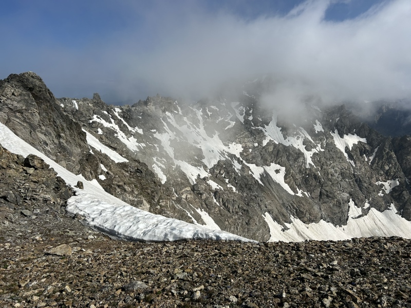
The next major tower contains the infamous "4th Class" move. As seen in the above picture, there is a nice crack running up the right of the tower beneath a bit of an overhang. Upon getting roughly halfway up said crack, you turn left and scramble up a boiler plate maybe 10' tall. The foot and hand holds are ample and the exposure is minimal. Both my dad and I found this move enjoyable. I don't think I'm qualified to determine if this was actually 4th class or not, but some of the other stuff on the ridge definitely seemed a little more spicy. What I would consider possibly the crux of the day was descending off the second tower. There is a nice little catwalk that is maybe 50' long and 5ish feet wide at a moderate downhill angle coming off the summit. There's a small ledge one can drop their feet to on climber's right, and not too much on climber's left. I feel like if I say there were 200+ feet of air on both sides of you, one might envision said catwalk as a diving board—its not. The ledge on your right provides a little fall security and the rocks past that are just steep and gross. You'd have to really tumble to actually get going—but if you did fall you'd either end up at the bottom of the Arapaho Glacier or whatever mess is on the west side. Yuck. My dad and I both descended the catwalk without much issue. I thought it was really cool and walked down it—if I recall correctly my dad sort of crouched. At the bottom of the catwalk theres some sharp boiler plates one can walk along to continue moving down off the tower. Definitely 3rd class but nothing ridiculous. I don't recall this section being too hard. 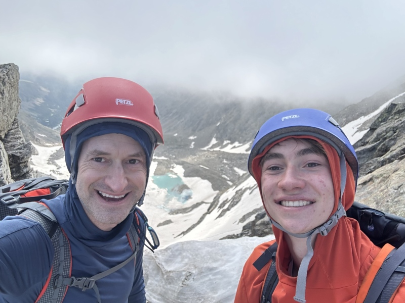
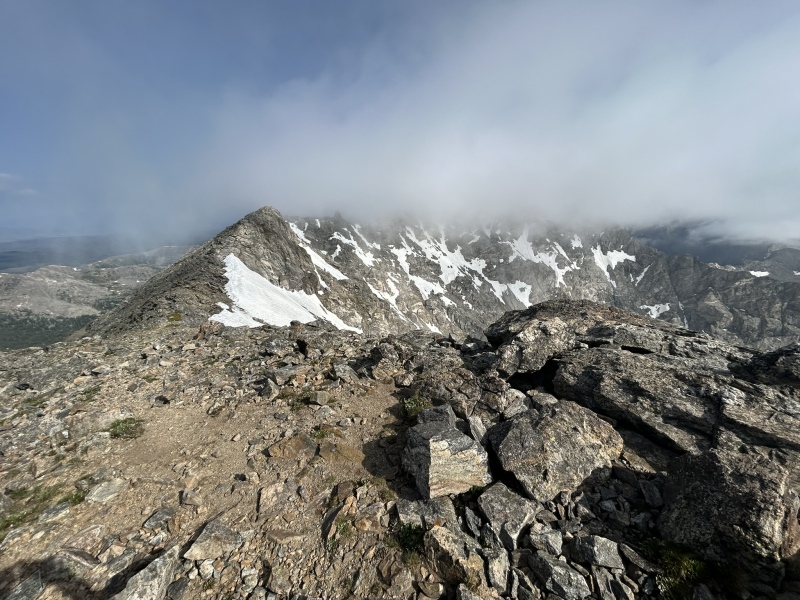
After this descent, the third tower loomed in front of us. It frankly looked gross, but luckily for us, there is a fairly visible notch to the left of this tower. I'll make an arrow point to it below: 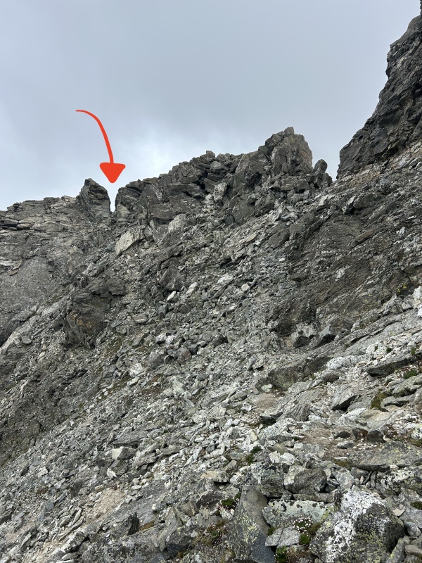
My dad suggested we explore to said notch, and I agreed. Upon the first inspection it looked like it cliffed out onto the other side... but no! There is a gully full of what I would call Class 2+/Easy 3rd scree and talus descending down a couple hundred feet on the western side of the ridge. A lot of reports I've read involve the climbers staying true to the ridge proper and taking it all the way up to the summit, but given that our notch deposited us a good couple hundred feet below the ridge, we instead swung far left around some cliffs on the final push up North Arapaho. I don't have any pictures from this point, but I can recall it being a loose mess of talus. But what is mountaineering in Colorado without loose talus?!?! This is what we live for!!!! Remember those happy clouds I was talking about earlier? About halfway down the notch gully, I turned around to see that, as happy clouds tend to do, they had expanded to multiple times there original size and turned a dark shade of grey. Given the weather forecast, I immediately knew that our time to get off the ridge was ticking before those happy clouds unleashed their lightning on us and turned us into deep friend versions of ourselves. We scampered up to North Arapaho, tagged the summit and began heading back. 

We made our way down North Arapaho, back through the notch and began traversing the 3rd class ledges towards the catwalk. Things were looking alright until we set foot back on the catwalk—my dad asked me to go first so he could watch where I stepped. One thing I really value about my dad as a climbing partner is that he is great at communicating what he's thinking and how he's feeling, so I know what is and is not within our ability level as a team at any given time. Both of us had tired legs at this point and were pretty stressed about weather, and my dad told me that he didn't feel up for the catwalk. We walked back down towards the notch to talk about what to do next, as there wasn't another great option. He told me that he was feeling shaky on the exposure, and frankly I did too. We decided that trying to take some ledges down the side of the ridge to try to wrap back around towards South Arapaho would be our best option. So that's what we did. 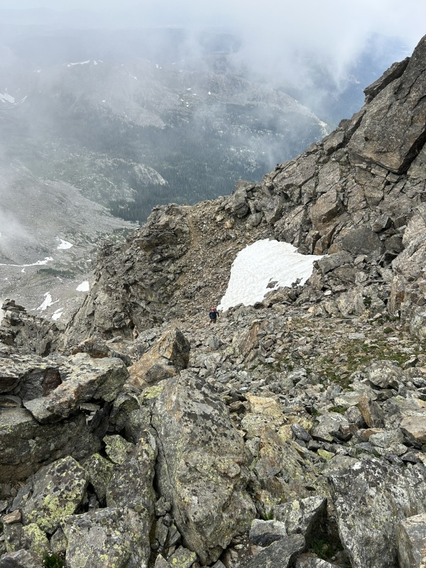
The western side of the ridge, especially near South Arapaho, is a mess of cliffs and scree fields. However, most of the cliffs were up high, and by losing 300-400 feet we were able to begin traversing grassy slopes, ledges and talus fields. Due to the mist that surrounded us, we could not see the ridge crest or the clouds above us. Our tired legs resulted in us losing about 30 minutes by dropping down and traversing below the ridge, but despite having to bail on fun scrambling, I believe there is actually a silver lining here! The main piece of beta I want to offer is that, with careful route finding (and probably having done this ridge before), I am fairly confident there is an Easy 3rd (?) class way to bypass the entire ridge crest by dropping low just before the first tower. After traversing scree for probably a half mile below the first and second towers, we found ourselves next to some cliffs that luckily had a way above them that intersected a large gully. Only after reaching the top of this gully did we realize it was the same gully we partially descended to bypass the first tower, meaning we had successfully swung beneath all three major towers by using the notch bypass around the 3rd. We whooped in joy to realize we had found a way around the exposure my dad was feeling unsure about and began trekking towards South Arapaho, just a few hundred feet away. Now, is taking this (potential) Class 3- bypass worth it? No! It was terrible, painful, and really really not fun! But nevertheless, it also did mitigate the lightning risk a little and could offer a decent bail. I still really don't recommend trying to replicate this though. THE DESCENT So if the traverse pushed my dad out of his comfort zone, getting off the mountain certainly pushed me out of mine. Here's a little background: A handful of weeks before this climb, I was hiking to Bluebird Lake in RMNP. A pretty standard day hike, I'd never done it before but quite enjoyed it. We hit the lake around noon just as a large thunderstorm was building, so we took a quick picture and got back into treeline as quickly as we could. I very distinctly remember being close to a thousand feet below treeline when my group began walking through an open area caused by a rockslide. The sky above us wasn't even fully covered by clouds, it was just slightly grey. We were all considering taking off our raincoats as it was barely drizzling. As we were in the middle of the rock slide, two bolts of lightning struck: one about a half mile away, on a ridge, and the other about a hundred yards away, straight in front of us. I can't really describe what it looked like because I was looking down, but all I remember was everything shattering. I thought our group had been struck, not because I saw a bolt, but because I felt it. The feeling was unlike anything I've ever felt before—it was as it the air had literally been broken by electricity and exploded. My skin was tingling, everyone's hair was standing up, and I could've sworn the ground shook. The boom was by far the loudest noise I've ever heard, and the next thing I knew we had all dove headfirst next to a big rock. Even though there were no more strikes, we all laid face down next to that rock for about fifteen minutes waiting out the storm. That's the most scared for my life I've ever been. As we finally touched the summit of South Arapaho Peak for the second time that day, we heard thunder somewhere off the ridge to our left, above the glacier. The mist still made it impossible to see, but nevertheless we knew that we had to descend quickly as to not be caught in the predicted electrical storms. Hail began to pelt us as more thunder boomed overhead, getting closer. The thing that puts me on edge the most about lightning is that is entirely out of my control—its almost as if fate is choosing if I'm going to get struck. And given how ridiculously powerful the strike a hundred yards away from me seemed, I really don't want to experience that power up close. I sadly don't have any pictures from this portion of the climb, as we were scampering to get back to treeline. If you've ever climbed South Arapaho Peak before, you'll know that from treeline to the saddle between South Arapaho and Old Baldy is practically a giant open alpine meadow the entire time. During one portion of the storm, my Dad and I went into lightning position next to some large boulders in said meadow portion because of some particularly loud thunder almost directly overhead. Hiking down through the open meadows during the storm had me on edge the entire time, similarly to how my Dad had felt on many of the exposed moves we had climbed during the traverse. Funny how different things affect different people, yeah? Luckily for us, we (nor anyone else descending at the same time as us) got struck. At the 4th of July Mines, the hail stopped and we cruised smoothly down the trail, laughing about the precariousness of the situations we had just been in. The fun scrambling aside, this may have been my favorite part of the hike, just getting quality time with my Dad in one of the prettiest places I've ever been. I believe that the mountains bring out the best in us—part of why I love them so much. CONCLUSION Well, as I'm writing this I've been up for way to many hours, but as usual with 14ers.com trip reports I'm glad I just typed it all out. The only decent beta one might be able to pull from this is our horrible ridge bypass, so I hope you were able to get something more out of this little adventure than just that. The moral of the story? Pushing yourself is a good thing—hopefully both my Dad and I will be more prepared for future alpine excursions in the future. We are planning to give the El D - Wilson traverse a go later this summer... we'll see how that goes. Thanks for reading and happy trails!! Thumbnails for uploaded photos (click to open slideshow): ")
")
")
")
")
")
")
")
")
")
")
|
| Comments or Questions |
|---|
|
|
Caution: The information contained in this report may not be accurate and should not be the only resource used in preparation for your climb. Failure to have the necessary experience, physical conditioning, supplies or equipment can result in injury or death. 14ers.com and the author(s) of this report provide no warranties, either express or implied, that the information provided is accurate or reliable. By using the information provided, you agree to indemnify and hold harmless 14ers.com and the report author(s) with respect to any claims and demands against them, including any attorney fees and expenses. Please read the 14ers.com Safety and Disclaimer pages for more information.
Please respect private property: 14ers.com supports the rights of private landowners to determine how and by whom their land will be used. In Colorado, it is your responsibility to determine if land is private and to obtain the appropriate permission before entering the property.

