| Report Type | Full |
| Peak(s) |
Rinker Peak - 13,789 feet Twin Peaks - 13,341 feet Twin Peaks B Northeast - 13,270 feet |
| Date Posted | 08/21/2024 |
| Date Climbed | 08/17/2024 |
| Author | samuelbaird |
| Bagging three seldom climbed peaks |
|---|
|
Introduction: Three Peaks in One Epic Day Twin Peaks North and South, and Rinker Peak, are the towering peaks prominently visible from the Twin Lakes area. Most will never know the names of these, less ever setting foot on these megaliths that rise with over 3,500' of prominence over the upper Arkansas River Valley. I've had my sights set on these since the day I laid eyes on them. Rinker Peak, being a bicentennial peak, and Twin Peaks, being unranked, are several orders of magnitude less popular than the 15 14ers in the Sawatch or the 14 centennial 13ers in the same range; it is true, no other mountain range in Colorado has more peaks over 13,800'. That being said, it came the time where I finally needed to bag these seldom-obtained peaks. 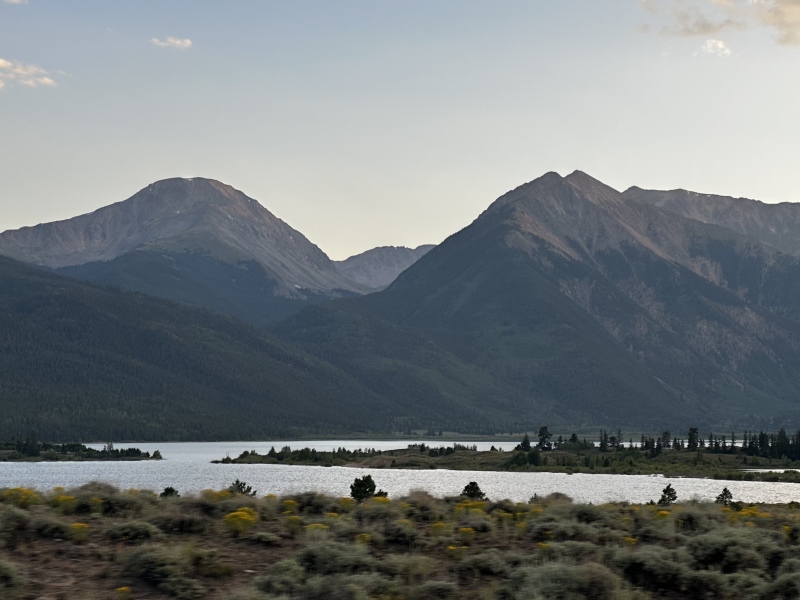
Seldom Obtained Peaks: The Climb to Obtain Them The day was a "mid-early" alpine start: around 7am on a day with zero weather forecast until after 4pm, enough of a safety margin that myself and my climbing partner were comfortable sending the nearly 5000' of vertical and 12mi R/T route to bag these, with confidence that we would be well below treeline before any disagreeable weather moved in. Of course, with many 13ers, these no exception, it is imperative to prepare sufficiently, and what some would call over-prepare, because often the known routes to these seldom-summited peaks contain little if any trail, and the odds that it's maintained are even lower. Not to mention that the odds that another climbing party would even be on the same approach trail, let alone the route to the summit, even on a late-summer Saturday, is low. Indeed, we saw no other climbers for the rest of the day, once leaving the main Hope Pass trail (concurrent with the CTD and CT) and ascending Big Willis Gulch. A note on preparedness: Even if neither of us touched or needed it, we both packed extra layers, food, water, and the means to filter more. Being trained in wilderness medicine, I always take the additional step of making sure to have a medical kit containing a SAM splint and enough coband to splint an injured extremity, or to cover anything from a minor to a major laceration, as well as a space blanket, which would prove invaluable if anyone became stranded on the mountain. Even with a fully charged phone, headlamp, GPS watch, and the means to charge and recharge all of these, an old-school topographic map and compass is also an essential part of any serious mountaineer's kit. Make no mistake, even for the most experienced mountaineers, the words "it can't happen to me" are usually an accident victim's last. I cannot stress enough the importance of taking peaks such as these, or any peak really, seriously, and respecting the mountains which are indifferent to skill, fitness, experience, or lack thereof. Myself and my climbing partner are both experienced and in good fitness for strenuous hikes at this altitude. After the hike, we both agreed it is not one that is beginner friendly. At worst, the climb never exceeds Class 2. However, it is a strenuous hike, with ~2,400' of elevation gain in the first 4.6mi, and the other 2100' in the final 0.6mi to the summit of Rinker Peak. Leaving the Big Willis Gulch trail around 11,700' it's pretty much directly up the mountain from there. You will pick up remnants of an old miners' trail that switchbacks up the slope, making the demanding climb a bit more enjoyable. Eventually, the miners' trail fades, and your only goal is up, up, up. Once on the saddle, you are faced with another 600' or so of vertical, Class 2 hiking along bits of talus and tundra to the summit of Rinker Peak. This mountain makes you work for it. We were up on top of Rinker just before 11am, about 3.5hrs into the adventure. With Twin Peaks ahead of us, the day was less than half-over, but the majority of the vertical was out of the way. After ~4,500' from Willis Gulch TH to the summit of Rinker, most of the remaining elevation gain would be ridge-saddle-peak hopping. 
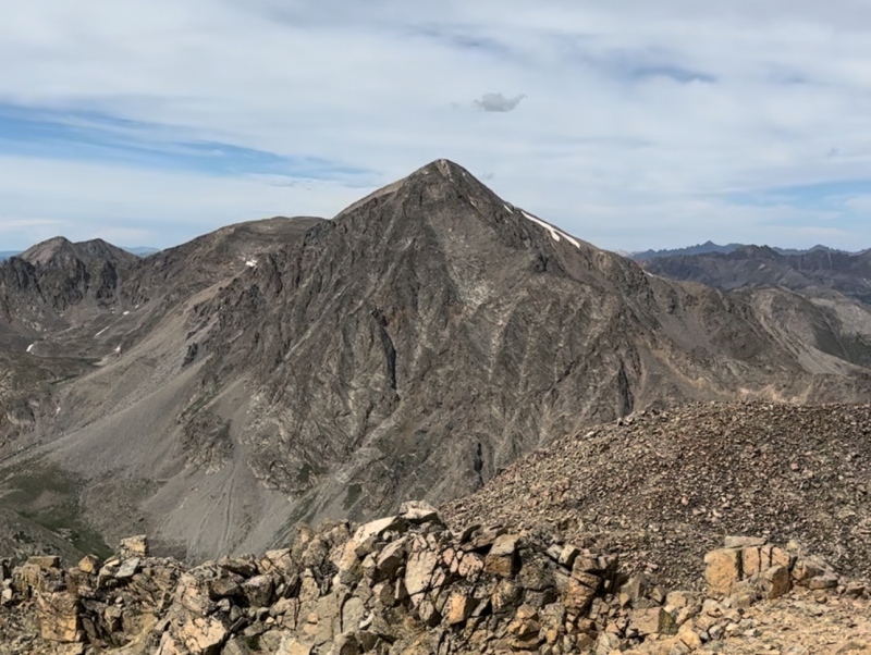
One Down, Two to Go Being a mountain-head, I of course found the views to the west and south more interesting. To the west, the rugged peaks of the Elk Mountains are visible beyond the ridgelines in the Sawatch and Independence Pass. The views to the south were just as, if not more interesting, with the endless sea of the Sawatch range visible in almost its entirety. To the SW, you are directly afforded with sweeping views of 13ers Mt. Hope, Elvin, Blaurock, and many more unnamed peaks directly in front of you, with 14er Huron easily identifiable. To the south, your view is mostly blocked by the gigantic Mt. Hope, but along the ridge you can make out the tips of Belford and Oxford just barely peeking above the mass of rock. In the distance, you can identify more of the legendary 14ers of the Collegiates making themselves known, as you traverse the ridgeline. 
After returning to the saddle, it is fun ridge hiking along a straightforward ridge. From the saddle and the false summit of Twin Peaks, the grade is pleasant and involves pretty comparatively easy hiking, with minimal Class 2 moves required, navigating around some small gendarmes along the ridge. This is an interesting section of the climb and a lovely place to be. For the Twin Peaks, the taller of the two, Twin Peaks South (13,341') is a small summit area with barely any flat spots, it almost blends right in with the ridgeline. We stopped, quickly signed the summit register, and continued to Twin Peaks North (13,270'), where the eastern panoramic views off of this massif awaited in all their glory. The 2nd and 3rd 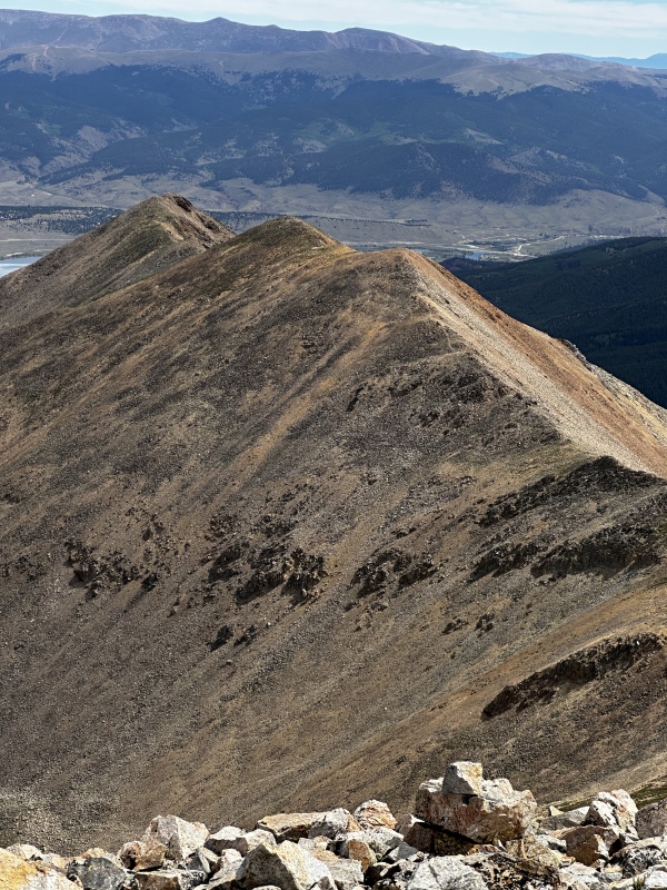
From the Twin Peaks, the sweeping views over the Twin Lakes, and long meandering ridgeline of the Mosquito Range were what dominated the view. The town of Leadville looked like a small blip in what was at one point a vast sea of untouched wilderness. Moments like this make you wonder what the pioneers and early explorers of these mountains were really up against. To traverse these rugged ridges, mountains, and vast valleys without the modern luxuries of paved roads, 4WD, heater cores, gore-tex, or any of the like, must have been a mission. A mission that, perhaps inherent in human instinct, still drives those to push the bounds of exploration to this day. A mission, that motivates less than a dozen people annually to summit these very peaks I'm walking on. It checked out: we were entries #6 and 7 for Twin Peaks for 2024, with only 7 signed ascents from 2023, and even less from 2022. It seems that one or two fewer people made the trek to bag Twin Peaks after summiting Rinker (or maybe, they couldn't be bothered to sign a summit register). Even still, as of myself and my climbing partner, there were still less than a dozen recorded ascents of Rinker for this year. 

The Descent There are three viable known routes off of these peaks. Returning via the gully you ascended, which involves an ascent back over Twin Peaks South and ~1,500' down; the NE ridge from Twin Peaks to Willis Gulch, which, according to geojed's synopsis of trip reports did not sound at all appealing (talus hopping, bushwhacking, "sketchy", "rolled ankle", "tiring"), and the south gully directly from the Twin Peaks saddle to Big Willis Gulch, documented on 14ers.com by geojed. It involves some fairly straightforward route finding, but still requires care on the descent, dropping nearly 2000' of elevation in an extremely short distance. This way (or really, as we were convinced mid-way down the gully, any way) off of the Rinker-Twin Peaks massif was surely going to have a level of suck. Cold plunge your knees in the snowmelt-fed creek in Big Willis Gulch, if you must. In full summer conditions, the route down was at worst slippery and loose. At best, it was soft and firm grassy tundra. It took about an hour to reach the forest, from there following the edge of the forest between a talus field, and short jaunt to the trail we were on our way out. The rest of the descent was pleasant trail hiking and we (read: our legs) were grateful to be on soft ground after fighting gravity for an hour. 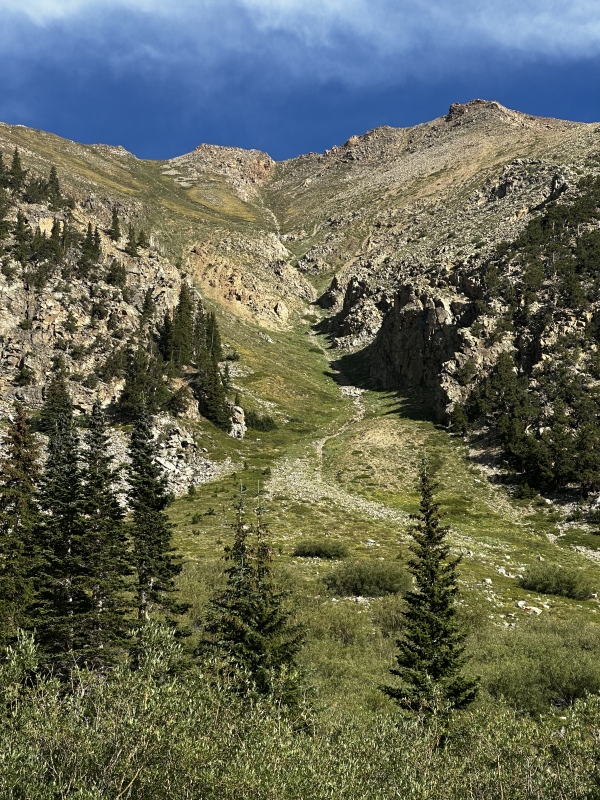
It is important to note, that from the top of the Rinker-Twin Peaks massif, the northern slopes of both look like perfectly viable and decent descent routes, that will almost plop you right back out on Hwy 82. If you're the type that's interested in some Class 5+ downclimbing on your descent, then it may be for you. What you cannot see from the ridge are the cliffed out sections in the trees below, and if you make it through that, then you'll need to figure out how you're going to cross the roaring Lake Creek river to get back to the trailhead. Overall this was an epic day, epic hike, with epic views. It took almost exactly nine hours, including breaks on the summits for photos, snacks, and a rest. I would recommend an early alpine start on any day that the forecast is more than a 10% chance before 2pm. In the mountains, the mountains make their own weather. If the atmospheric conditions are correct for thunderstorm development, a forecast for, say Leadville, indicating a "30% chance after noon" means a "50% chance around 11am" for anywhere above 13,000ft. On this day, the forecast was a 10% chance after 4pm. We did not see storm clouds forming until almost exactly 4pm, and did not experience any rain at all on the hike. Looking back over Twin Peaks and Rinker Peak on the drive out, I saw a dark ominous storm cloud pretty much directly above the mountain. It did not appear to be raining up there, but we were glad we made good time with the knowledge we had about the weather, and completely avoided it. Anyone who would have started later, or kept a slower pace, or attempted these peaks on a day with less ideal weather forecast, might have gotten caught up in a dangerous situation up there. It is a hike I'm happy to have done once, having bagged the peaks that command so much attention from the ever so popular shores of the Twin Lakes. Thumbnails for uploaded photos (click to open slideshow): ")
")
")
")
")
")
")
")
|
| Comments or Questions |
|---|
|
|
Caution: The information contained in this report may not be accurate and should not be the only resource used in preparation for your climb. Failure to have the necessary experience, physical conditioning, supplies or equipment can result in injury or death. 14ers.com and the author(s) of this report provide no warranties, either express or implied, that the information provided is accurate or reliable. By using the information provided, you agree to indemnify and hold harmless 14ers.com and the report author(s) with respect to any claims and demands against them, including any attorney fees and expenses. Please read the 14ers.com Safety and Disclaimer pages for more information.
Please respect private property: 14ers.com supports the rights of private landowners to determine how and by whom their land will be used. In Colorado, it is your responsibility to determine if land is private and to obtain the appropriate permission before entering the property.

