Leaving a short write-up to provide some additional color to the Southwest Ridge route description, mainly to highlight a hazard that may carry more weight for solo hikers.
The beginning of this hike with the ascent through the gulch and then across the basin to the headwall reminded me quite a bit of the Jennings Creek approach to Tabeguache. Along with the similar terrain characteristics, it shared the heavy erosion of certain parts of the trail especially the steep dirt/scree section you ascend in order to pop through the notch and on to the ridge proper. After the hike I found myself wondering why the USFS no longer maintains and advises against using the Jennings Creek route but doesn't seem to have similar concerns about this trail.


Hiking up the scree/loose dirt section of the wall at the far end of the basin is as advertised. About 400 vertical feet of it is the worst, but it wasn't difficult to stay upright during the ascent. Descending was another matter entirely. I managed to stay balanced and surf large sections of this in my trail runners without actually falling, but it was a close thing more than a few times. I don't carry poles and maybe poles help, but leaning slightly backward so that a fall would land you on your rear end seems preferable to leaning forward in to poles and potentially launching forward.
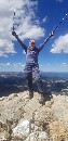
Entire hike up to and including this section goes very quickly and it's an easy jaunt on the ridge over to the big boulder hill (the 'prominent rocky slope' in the route description), which is the thing I wanted to write about.
The rock is 'mostly stable' as in you are not likely to send any tumbling down behind you, but many of them will still shift under your weight. There is plenty of mischief underfoot on this slope. With decent legs it's practical to just brute force your way straight up the thing and be done with it. I spotted very few cairns at all, and the random patch of dirt really didn't offer better footing. Get up and over it and then pick your way through another flatter section full of even more rocks and you're just about home free. Views along the way and from the summit defintely make the juice worth the squeeze on this route. But you do have to get back down...

Coming back down the rocky slope is really what I wanted to highlight here. For a solo hiker, consider that you are one stubbed toe or one mischievous rock from a sprain (best case) or, in some of the steeper spots, getting tossed into the air with some variation of a horrific outcome upon landing - and you need to dodge that bullet each of nearly a thousand steps as you make your way down. I tried to switchback best I could to minimize the risk of a sudden unplanned descent, but realize that the risk is not entirely avoidable. You can't just keep walking sideways.
Yes you accept a lot of risk going out solo any time and there are other sections on other mountains with similar characteristics, but this one seemed a bit more dangerous than the rest (perhaps because of how long it is) so I thought it would be worth calling out as the route description's advice of 'still be careful' doesn't quite capture the essence of the thing. I also only saw two other hikers the entire trip on this route, and they were a few hundred yards across the slope when we passed. Looking back I felt like I made a poor (if uninformed) decision and that I should have tagged this peak when a friend was available.
I am very much a 'buy the ticket, take the ride' sort of person and do not judge people for the risks they take (or choose to avoid), so best of luck to future you whoever you may be and I hope this was helpful.
")
")
")
")