| Report Type | External |
| Peak(s) |
Mt. Shavano - 14,230 feet Tabeguache Peak - 14,158 feet Jones Peak - 13,609 feet "Esprit Point" - 13,627 feet |
| Date Posted | 03/31/2025 |
| Modified | 04/01/2025 |
| Date Climbed | 03/26/2025 |
| Author | justiner |
| Shavano Swish-Swish |
|---|
|
A nice time on Shavano and friends. I took the Bustang Denver-Crested Butte to Salida with bike and backpack in tow and took a leisurely ride up to the Shavano Trail, as I've done many, many times in the past. There's a snow drift maybe 2 miles before the TH, which was easy enough for me to walk over, but given the lack of anyone else at the trailhead, seems to be keeping people away. 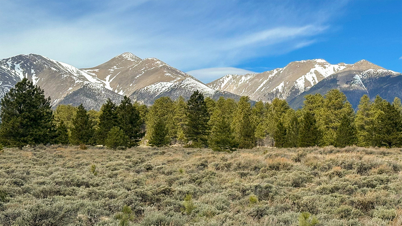
As the sun dipped down, I walked the last mile or so, as the road was also getting a little muddy and I was at the limit of my 2-speed rig. Made camp, then went to bed pretty early. Work up at 3:30 am for my plan of going up Jones Peak's east ridge to summit Jones/West Jones, then visit Tab/Shav, after finally descending down Esprit's east ridge -- a nice little loop. Trail conditions were relatively dry, although when the trail dipped down into a drainage and turned towards the north, snow banks were present. Not many footprints after the standard route, but a few from elk, and maybe from an errant cow. Happy to have brought my children's snowshoes which work... enough -- and are very lightweight and stow-able. East ridge of Jones started out well and I enjoyed a nice sunrise. Snow started maybe a half of a mile before treeline. The snow was somewhat set (temp at camp never got to below freezing), but a bit of postholing did happen. Thankfully, a short matter. Easy tundra/talus hopping for the majority of Jones Peak. Several big horned sheeps spotted and one white long-tailed weasel darting through the rocks which is always a fun thrill. Jones' summit isn't much, so I moved on. Fun scrambling between Jones - West Jones, I would suggest keeping as close to the ridge as possible. One short snow slope to deal with to get up West Jones, but nothing too difficult. Happy to have microspikes for that 20 feet. The bop to Tab was an easy walk, and the route to Shav was pretty familiar. 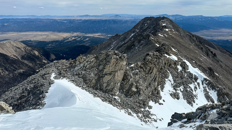
Esprit was now my focus. Getting to it couldn't be easier, but I wondered what the descent may be, given I had hit snow coming up and now several hours had past. Hitting treeline again brought snow, and I was soon wallowing up to my hip in very warm mush, trying not to get stuck in a tree well. Pretty funny stuff. If I had gone more north, I probably would have missed most of the snow, at the expense of more hiking north on the CT whenever I finally joined up (and probably worth it) By this point, I was pretty tired both in mind and body, and thought I was on my way to re-join the standard route, but that was a mistake on my part. I instead paralleled the standard route and bushwhacking through the forest as the snow slowly receded. Thankfully though, I had worn vapor barrier socks. Before this, my feet had been quite warm. But now my shoes and my socks were drenched from essentially being underwater for an hour+. I was able to take off my liners, wring up my wool socks of my of their moisture, put those on and put my vapor barrier socks over those to protect them from getting any more wet from my shoes, which were now never going to dry out. I met back up with the CT almost at the trailhead, pretty cold from being so wet. But, I had tons of clothes back at the bivy and bike, so I changed, ate, and passed out again. I had dropped some camera gear somewhere before I started up the east ridge of Jones, so I got up early the next day to retrace my steps to see if I could find it. Given no one had been there since, I found my lost gear right in the middle of the trail, about two miles in. I retraced my steps to the standard route up Shavano and followed it for about an hour, just as a workout. I made it basically to the Angel of Shavano split, postholing for a good while before. I again donned my snowshoes and made good time back to the trailhead. After that, I packed up, and rode back to Salida to get lunch and check out the footage I took for work. The bus came back at 3:45pm and I hopped on, being only the second person they had picked up, A good little trip! I decided to go up the east ridge rather than the slope by Shavano Lake because the slope looked like a bad idea, avalanche-risk wise, but there wasn't much snow on the slope on this day, so that would have been fine, so long as you could get to the Lake. The "Lake" was barely holding on, seemed mostly dried up. I tried out a new-to-tarp, that featured a simple hoop over the head. Excellent bivy, can't wait to take it on more arduous trips! Thumbnails for uploaded photos (click to open slideshow): ")
 Neat cliffs by the West Jones Summit")
|
| Comments or Questions |
|---|
|
|
Caution: The information contained in this report may not be accurate and should not be the only resource used in preparation for your climb. Failure to have the necessary experience, physical conditioning, supplies or equipment can result in injury or death. 14ers.com and the author(s) of this report provide no warranties, either express or implied, that the information provided is accurate or reliable. By using the information provided, you agree to indemnify and hold harmless 14ers.com and the report author(s) with respect to any claims and demands against them, including any attorney fees and expenses. Please read the 14ers.com Safety and Disclaimer pages for more information.
Please respect private property: 14ers.com supports the rights of private landowners to determine how and by whom their land will be used. In Colorado, it is your responsibility to determine if land is private and to obtain the appropriate permission before entering the property.

