Download Agreement, Release, and Acknowledgement of Risk:
You (the person requesting this file download) fully understand mountain climbing ("Activity") involves risks and dangers of serious bodily injury, including permanent disability, paralysis, and death ("Risks") and you fully accept and assume all such risks and all responsibility for losses, costs, and damages you incur as a result of your participation in this Activity.
You acknowledge that information in the file you have chosen to download may not be accurate and may contain errors. You agree to assume all risks when using this information and agree to release and discharge 14ers.com, 14ers Inc. and the author(s) of such information (collectively, the "Released Parties").
You hereby discharge the Released Parties from all damages, actions, claims and liabilities of any nature, specifically including, but not limited to, damages, actions, claims and liabilities arising from or related to the negligence of the Released Parties. You further agree to indemnify, hold harmless and defend 14ers.com, 14ers Inc. and each of the other Released Parties from and against any loss, damage, liability and expense, including costs and attorney fees, incurred by 14ers.com, 14ers Inc. or any of the other Released Parties as a result of you using information provided on the 14ers.com or 14ers Inc. websites.
You have read this agreement, fully understand its terms and intend it to be a complete and unconditional release of all liability to the greatest extent allowed by law and agree that if any portion of this agreement is held to be invalid the balance, notwithstanding, shall continue in full force and effect.
By clicking "OK" you agree to these terms. If you DO NOT agree, click "Cancel"...
Holy Cross Wilderness ~ Cross Creek / Whitney Lake
HC WILDERNESS PART III
Another trip report in to Holy Cross Wilderness, first quick updates on route / trail conditions:
Tigiwon Road (as of Nov 1st): Patchy snow until you get to the Community Shelter approx 5 miles up, then the road becomes heavy snow. Tacoma in 4WD ate a drainbar a few times. Snow gets deep quickly after this point - roughly 8-10 inches, close to 12"+ at Halfmoon. There is a layer of ice under it - makes for tricky travel.
Cross Creek TH (as of Nov 1st) Sparse areas of snow and ice on the trail until you get the to Cross Creek. Fairly minimal snow for about the next 1.5 miles. Snow on the eastern sides of trail, and areas in the trees have 10-12" for quite a distance. The area just prior to the Grouse Mountain Trail is especially snowed in 12-16" (gaitors will serve you well). The trail is broken in to an area just past Grouse Mtn Trail prior to Reeds Meadows. You will need snowshoes beyond this point or anywhere in the Cross Creek / East Cross Creek area.
Whitney Lake TH (as of Nov 2nd) Trail is dry for the most part until you cross the creek about 1.2 miles up. From that point to the top of hillside the snow increases 8-10". About a half mile prior to the lake the snow gets deep, and lots of recent dead fall. The trail is broken in to the lake, gaitors would be good, snowshoes not needed unless you break trail or continue up Mt Whitney. Snow in the trees is 18-24" in some of that area approaching Whitney.
So, on to the trip report. This again focuses on a look in areas for missing hiker James Nelson. The areas of interest to both Elle and I was the Cross Creek / East Cross Creek confluence (CC/ECC). In a prior report we had bushwhacked down this route, but this time decided to scan from the Cross Creek drainage looking up. We arrived at a bowl just prior to Reeds Meadows and scanned from the base of the adjacent Grouse Mountain. We picked out five likely routes aside the drainage of East Cross Creek you would likely ascend. All except one sit at more than a 30 degree incline. There is roughly 2' of snow in most areas making the a risky slide area near some cliff bands and talus areas.
The image below shows an overview of the area. The red arrow is a shelf that appears to be the easiest ascent, however the entry to this would be above Reeds Meadow, about 1.5 miles west further up Cross Creek than the ECC/CC confluence. The tricky part is navigating the back to Half Moon once you reach the top... Talus, talus..
The red "X" is our photo vantage point for many of the photos below. The green area, is the bushwhack Elle and I took a few weeks ago before the weather turned, the green route down follows East Cross Creek slightly to the West. Overview map
Just a note: originally we were going to stage Elle's (mountain woman) truck at Half Moon Campground, and mine at Cross Creek TH and go up Cross Creek to East Cross Creek and then over Half Moon Pass to the other staged vehicle. Tigiwon Road was a mess the first night though - even with her Tacoma in 4wd she ended up in a drainbar a few times - the snow depth was well over a foot in places and icy underneath. We decided to stage both at the Cross Creek TH and go from there.
I uploaded one wide angle photo (panorama using Photo Stitch that shows all five approaches here: Wide angle of East Cross drainage
(I have this photo in extremely high res (15mpx - 500mb file). The one above has been reduced to 5% of it's original size..if anyone wants it - pm me).
Some photos of up Cross Creek Holy Cross from Cross Creek Ice all over
We arrived at the ECC/CC confluence directly across from Bowl of Tears and the North Ridge acsent to Holy Cross from the vantage point on Grouse Mountain, right at about the six miles from the TH. After we scanned the base looking up, we stashed our packs near the trail and ascended Grouse Mountain rather ultralight to about 10,500 to get a bird's eye view of the drainage. From there we picked out terrain features, likely routes, and cliff bands along the adjacent East Cross Creek drainage. We spent awhile scanning with binoculars in the likely drainage areas of East Cross Creek. Elle (mountain woman) scanning across to Bowl of Tears & East Cross Crk
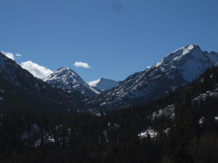
The snowline really starts after Reeds Meadows area - at least a foot in Cross Creek, two feet along the north side. Looking up Cross Creek from Reeds Meadow
Looking across to the bushwhack route of East Cross Creek East CC - looking toward Bowl of Tears
It was a 6 mile trek in, most of it breaking the trail in - about 8-10" for the last mile or two in most places.
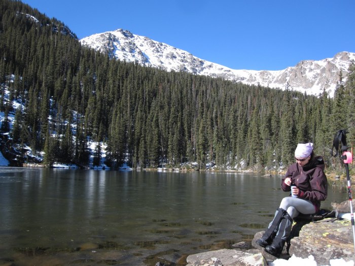
The following day we did an ultralight trip up to Whitney Lake to survey the conditions on Mt Whitney. Taking a break at Whitney Lake Up to Whitney Lake Up to Whitney Lake
The weather was optimum Nov 1-3, I imagine the snow amounts will decrease as this warmer weather moves in. Just a heads up and trail conditions for others heading out soon.
I wear the Beta shell (top) and I can't say enough good things about it. The pit zips are key. It's light weight for summer, and I layer in winter (I tend to get hot on any ascent, so ventilation was what I was after). Elle has both for the same reason. She ripped her old pants glissading, and picked up a pair of the arc'teryx this spring. They are built like a tank. I couldn't justify the price on the pants so I went with the REI equivalent - and they are awesome. I would highly recommend them.
We went about a half mile past the community center and bailed on the route since it was getting dark - and opted for the Cross Crk TH instead. I imagine with the warmer temps the snow level has gone down(?), but you should be able to make to at least that point in 4WD no problem.
Caution: The information contained in this report may not be accurate and should not be the only resource used in preparation for your climb. Failure to have the necessary experience, physical conditioning, supplies or equipment can result in injury or death. 14ers.com and the author(s) of this report provide no warranties, either express or implied, that the information provided is accurate or reliable. By using the information provided, you agree to indemnify and hold harmless 14ers.com and the report author(s) with respect to any claims and demands against them, including any attorney fees and expenses. Please read the 14ers.com Safety and Disclaimer pages for more information.
Please respect private property: 14ers.com supports the rights of private landowners to determine how and by whom their land will be used. In Colorado, it is your responsibility to determine if land is private and to obtain the appropriate permission before entering the property.


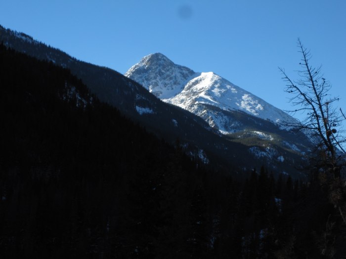


 Holy Cross from Cross Creek")
 Ice all over")
 Elle (mountain woman) scanning across to Bowl of Tears & East Cross Crk")
 Looking up Cross Creek from Reeds Meadow")
 East CC - looking toward Bowl of Tears")
 Taking a break at Whitney Lake")
 Up to Whitney Lake")
 Up to Whitney Lake")
")
 Wide angle of East Cross drainage")
 Overview map")