Download Agreement, Release, and Acknowledgement of Risk:
You (the person requesting this file download) fully understand mountain climbing ("Activity") involves risks and dangers of serious bodily injury, including permanent disability, paralysis, and death ("Risks") and you fully accept and assume all such risks and all responsibility for losses, costs, and damages you incur as a result of your participation in this Activity.
You acknowledge that information in the file you have chosen to download may not be accurate and may contain errors. You agree to assume all risks when using this information and agree to release and discharge 14ers.com, 14ers Inc. and the author(s) of such information (collectively, the "Released Parties").
You hereby discharge the Released Parties from all damages, actions, claims and liabilities of any nature, specifically including, but not limited to, damages, actions, claims and liabilities arising from or related to the negligence of the Released Parties. You further agree to indemnify, hold harmless and defend 14ers.com, 14ers Inc. and each of the other Released Parties from and against any loss, damage, liability and expense, including costs and attorney fees, incurred by 14ers.com, 14ers Inc. or any of the other Released Parties as a result of you using information provided on the 14ers.com or 14ers Inc. websites.
You have read this agreement, fully understand its terms and intend it to be a complete and unconditional release of all liability to the greatest extent allowed by law and agree that if any portion of this agreement is held to be invalid the balance, notwithstanding, shall continue in full force and effect.
By clicking "OK" you agree to these terms. If you DO NOT agree, click "Cancel"...
US Grant (13,767', Colorado #119) "V 4" (13,540', Colorado #228) Dates: 25-26 August 2019 Climbers: Mark and Hoot Trailhead: First switchback above South Mineral Campground Distance: 8.5 miles Elevation gain: ~3800' Difficulty: Short Class 4 crux on US Grant, easy Class 3 scrambling on "V 4"
US Grant has been on my bicentennial to-do list for a long time! While Mark had previously climbed US Grant, he was game to repeat it with a new tricentennial "V 4" added on, plus some fun camping.
Mark and I met just east of the South Mineral Campground not far from Silverton early Sunday morning and then drove my car up the easy 4WD road toward Clear Lake. After passing by the upper trailhead at the first switchback, now marked with no parking signs, I parked parallel to the road at a wide spot before the second switchback. A short hike down the road brought us to the convenient upper trailhead for Ice Lake Basin. The Clear Creek waterfall crossing not far in from the trailhead was an easy dry walk across logs for us at this point in the season.
Clear Creek waterfall along the upper trail
As we hiked up the main trail, we passed hoards of hikers coming down from Ice Lake Basin. About 1.3 miles up the trail near 11,400' we left the main trail at a large cairn and followed a surprisingly good trail leading directly up to Island Lake.
Turnoff from the main Ice Lake Basin trail to head up directly to Island Lake
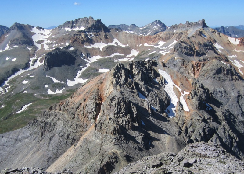
US Grant quickly came into view as we approached Island Lake.
US Grant from the flower-fill approach
Once we got to beautiful Island Lake, we scouted around the lake and then hung out on the water's edge until the weekend hikers had all headed back down the trail. At that point we pulled a 7-pound rubber raft (less than $20 on Amazon) out of my backpack and blew it up. With gear in a dry bag and about 250' of cord in tow, I paddled the raft from the northwest side of the lake to the Island.
Our first trip to the island
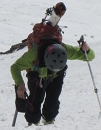
After I disembarked on the island, Mark pulled the raft back to his position with the cord, loaded up and paddled across with more gear. We made four trips to get all our gear to the island without exceeding the 200 pound limit of the raft. After securing the raft on the island with some big rocks, we set up our tents near the center of the small island on nice soft ground perfect for tent stakes.
Our tents on soft relatively flat ground on the island
The sun went down fast behind "V 4" and we crawled into our tents after dinner. With the wind blowing pretty strongly for most of the night at 12,400', I didn't get the best night's sleep. But it was a campsite I'll always remember! In the morning after breakfast, I loaded the dry bag with gear and paddled the raft off the island to snap a few photos before taking down the tents.
Our somewhat secluded campsite in the middle of Island Lake
In the morning, we got all our gear off the island with just three trips to the shore. Our inexpensive little raft did its job well.
Mark headed back to the mainland with a big bag of gear
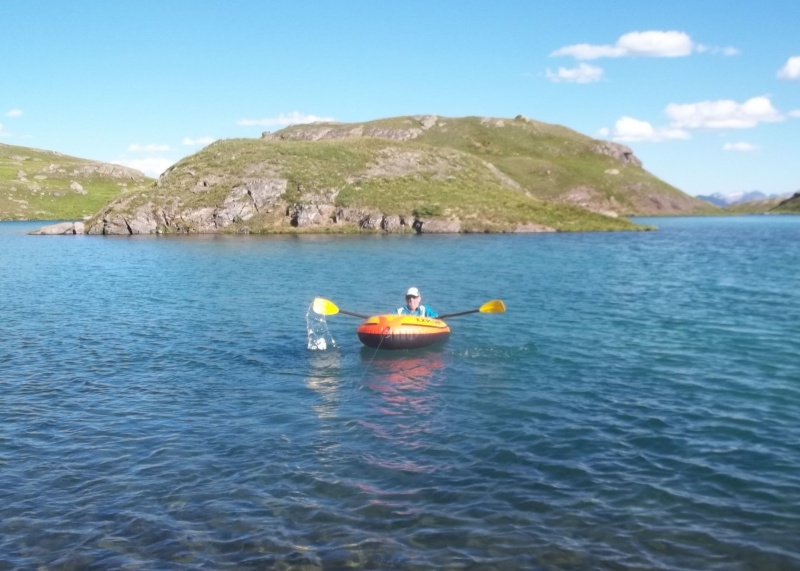
Mark and I buried the gear we didn't need for the climb under big rocks to protect it from marmots. There were plenty marmots hanging out in the area. We started hiking up toward the US Grant-V4 saddle at around 9am under clear skies. The climb to the saddle on grass then dirt and talus was easy and not all that steep.
The easy climb up to the US Grant-"V 4" saddle
At the saddle we turned right to follow the ridge toward US Grant. There were a few places where you could go right or left along the mostly Class 2 ridge with either way working. When it got a little steeper and Class 2.5ish, we put on our helmets.
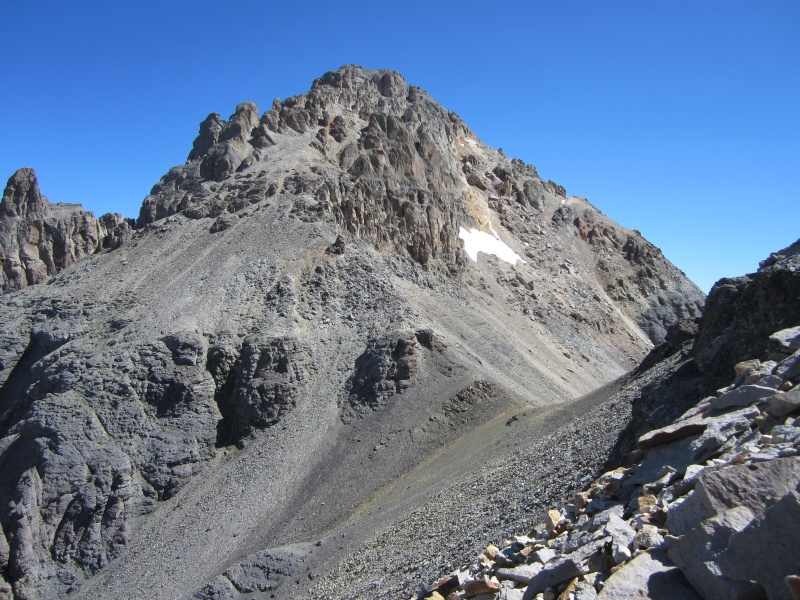
Start of US Grant's west ridge from the saddle with "V 4"
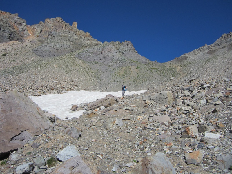
It didn't take long to reach the headwall high on the ridge which makes US Grant an interesting climb.
The headwall high on US Grant's west ridge - the traverse ledge is clearly visible about halfway up
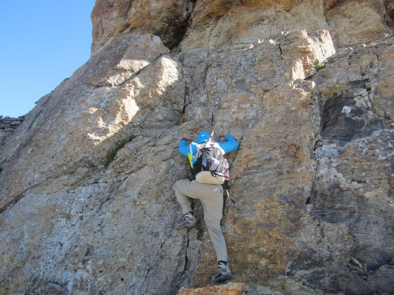
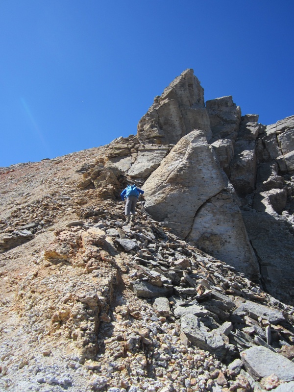
From the base of the headwall we followed the standard route which consisted of climbing a crack about 20 feet up to a ledge, and then traversing right along the exposed ledge for about 50 feet.
Starting the short Class 4 crux climb
The crack climb felt like easy Class 4 to me. However, one or two moves while descending the crack on our return, kicking around for a good foot placement, definitely got my attention. Experienced rock climbers likely won't want to bother with protection on this short pitch. However, those without rock climbing experience might appreciate a belay or at least some spotting here.
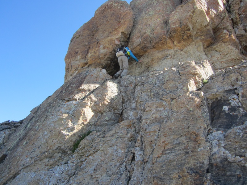
At the top of the crux climb with the exposed ledge traverse to the right
The beginning of the ledge traverse was quite exposed, but not difficult. I'm just glad it wasn't covered with snow and ice.
Looking back at the exposed ledge traverse
The climbing above the ledge was fun and easy with a bit more Class 2.5 terrain.
Easy scrambling above the ledge leading to US Grant's summit
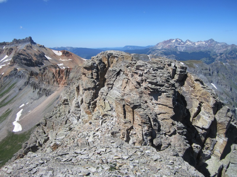
It didn't take long to reach the large summit area once past the crux.
Final stroll to US Grant's summit
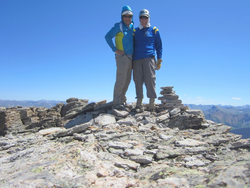
US Grant's summit provided great views in all directions, especially the views of Ice Lake Basin.
V4's summit from US Grant with Fuller, Vermilion, Golden Horn and Pilot Knob in the background
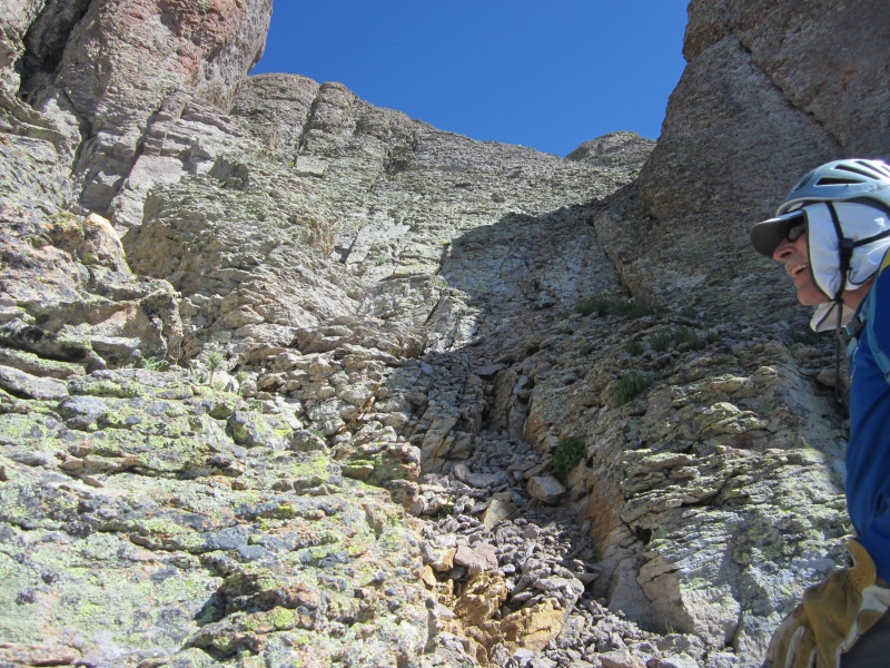
After spending a little time on the summit, we headed back down toward the saddle. At one point we got a bit further left (south) than we intended along the ridge but had no problems getting back on track. Once back at the saddle we continued across toward "V 4". We didn't have much beta on V4, but knew we needed to traverse to the right around the north side of the first (northeastern) tower cluster. Without gaining much elevation from the saddle we follow a faint path through the talus and avoided a patch of snow to come to a wide, moderately steep talus-filled gully.
Looking back at US Grant and the saddle from our start on "V 4"
From this point we climbed up the wide gully on occasionally loose talus to V4's northeast ridge between the first and second tower clusters. At the top of this gully, we rejoined V4's northeast ridge and continued climbing on the east (Island Lake side) of the ridge.
Mark climbing on reasonably stable talus approaching the second tower cluster from the northeast
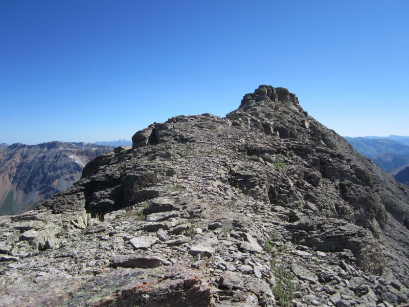
With a little bit of fun and easy Class 3 scrambling, we reached the top of V4's second tower cluster. It was not clear to us whether or not this was V4's true summit. After consulting our maps and GPS's, we surmised that we were not on the true summit and needed to continue on to the next tower cluster to the southwest.
V4's highest tower cluster from the second tower cluster to its northeast
We climbed down from our position and traversed southwest on the south side of the ridge to the next cluster of towers which provided more fun and easy Class 3 scrambling.
Mark checking out V4's towers with US Grant in the background
After exploring a few of the towers in this cluster, we reached a large flat area with a cairn and decided that was V4's true summit. We're 99% sure of that! But there was one more tower cluster to the southwest that looked just about as high.
We're 99% sure this is V4's high point
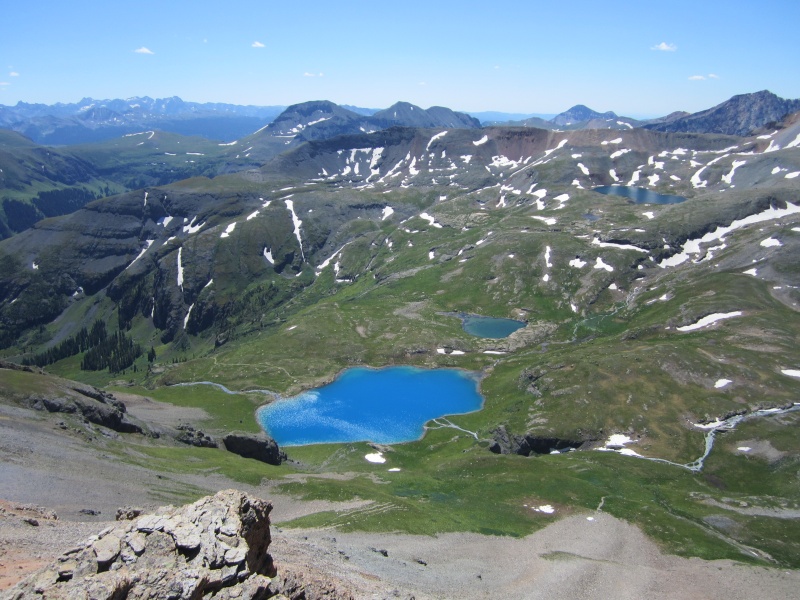
V4's summit provided great views of the adjoining Ice Lake and Island lake basins.
Ice Lake from "V 4"Island Lake from "V 4" with "V 2" above and just left of the lake
After enjoying V4's summit, Mark and I largely retraced our route back to the saddle and then back down to our gear at Island Lake.
Returning to Island Lake
With all our gear packed up, including the raft, we hiked clockwise around Island Lake through dense wildflowers and across a large snow field. We briefly considered climbing "V 2" just above us, but decided to save it for a return visit. We headed back down the trail a little after 2pm under still crystal clear blue skies and made it back to the car by 3:15 pm.
Parting shot of "V 4" towering above Island Lake
US Grant was my 153rd Colorado bicentennial peak and it did not disappoint. "V 4" was something like Mark's 250th Colorado tricentennial peak and a very fun add-on to US Grant. On the agenda for the next day - Lookout and Bridal - another bi/tri pair.
Topo of our route
My GPS Tracks on Google Maps (made from a .GPX file upload):
...you saying last summer that US Grant was on your to-do list for 2019. Nice to see you added V4 to your climb of Grant this year. That campsite looks like a lot of fun, BTW.
I've tried twice to float out to the Island, but been stymied each time. Once, it was 38 degrees in August. The other time, it was raining steadily.
Did you see any ghosts? In Navajo lore, the island is called H'aj'ii'na'i', or "The place of emergence." It's believed this is the place where the Navajo emerged from the underworld and where the spirits of the dead pass to the nether world.
NIce shots of the Grant crux, BTW. I wish we'd just climbed back down it...
Boating over the island is brilliant! Way to minimize someone sharing your campsite without prior notice.
Caution: The information contained in this report may not be accurate and should not be the only resource used in preparation for your climb. Failure to have the necessary experience, physical conditioning, supplies or equipment can result in injury or death. 14ers.com and the author(s) of this report provide no warranties, either express or implied, that the information provided is accurate or reliable. By using the information provided, you agree to indemnify and hold harmless 14ers.com and the report author(s) with respect to any claims and demands against them, including any attorney fees and expenses. Please read the 14ers.com Safety and Disclaimer pages for more information.
Please respect private property: 14ers.com supports the rights of private landowners to determine how and by whom their land will be used. In Colorado, it is your responsibility to determine if land is private and to obtain the appropriate permission before entering the property.


")
")
")
")
")
")
")
")
")
")
")
")
")
")
")
")
")
")
")
")
")
")
")
")
")
")